
Cloud/sun mix and a warming trend this weekend; shot at a record on Sunday
How cloudy has it been?
Go Deeper.
Create an account or log in to save stories.
Like this?
Thanks for liking this story! We have added it to a list of your favorite stories.


It was great to start the day with some sunlight!
Much of eastern Minnesota was able to see the rising sun this morning, but clouds or a cloud/sun mix are on tap for most of us this afternoon.
We all know that January was cloudy on many days. According to the Minnesota State Climatology Office:
Weather in January can range from clear and crisp to cloudy and gloomy. January 2020 is following the latter. So far though January 27, January 2020 has had the least amount of solar radiation for a January since solar radiation records began at the U of M St. Paul Campus Climate Observatory in 1963.
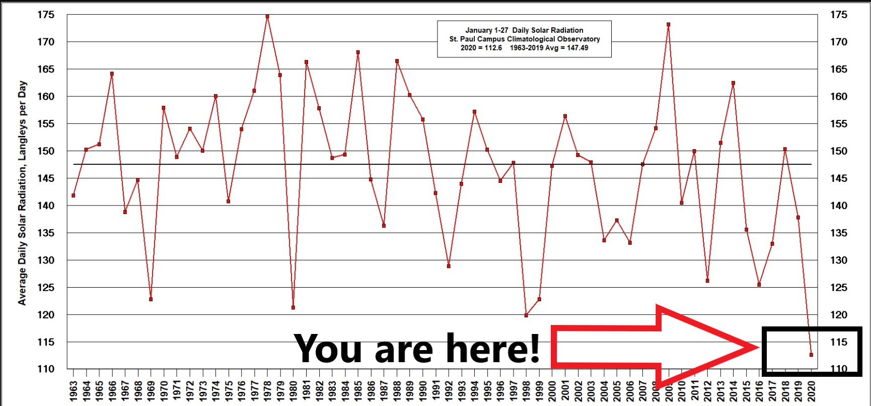
Following the Climatology Office post on Jan. 28, we had cloudy skies for the remainder of January, with the exception of a few brief glimpses of sun.
Turn Up Your Support
MPR News helps you turn down the noise and build shared understanding. Turn up your support for this public resource and keep trusted journalism accessible to all.
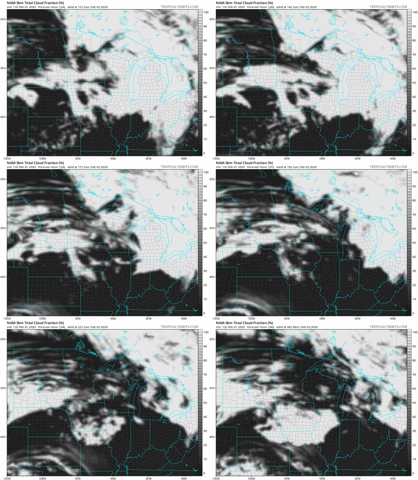
Our Sunday will feature a mix of clouds and sun. The National Oceanic and Atmospheric Administration’s North American Mesoscale forecast model shows the percentage of cloud cover on Sunday:
Temperature trends
Our average high temperature is 25 degrees this time of year in the Twin Cities. We’ll probably top out in the upper 30s this Saturday afternoon, and highs in the 30s are also expected across most of Minnesota and western Wisconsin. A few spots in southwestern Minnesota could touch 40.
Sunday highs reach the 40s across most of central and southern Minnesota, as well as western Wisconsin:
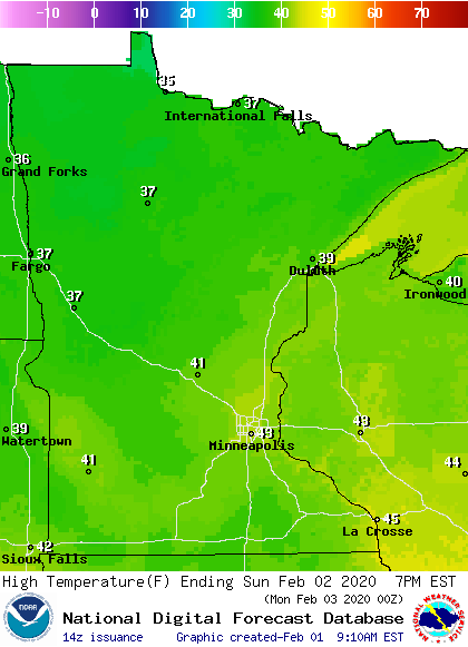
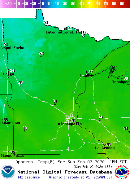
We could have a high temp in the mid 40s Sunday afternoon in parts of the metro area, but the winds will pick up. Sunday afternoon wind chills will be in the 30s across much of central and southern Minnesota, with 20s north:
Twin Cities high temps are projected to be in the upper 20s Monday, around 20 on Tuesday, then in the lower 20s Wednesday and upper 20s on Thursday and Friday.
Record setting warmth?
Some spots, including the Twin Cities could see a record warm low temperature on Sunday:

Low temps are for the entire calendar day, which doesn’t end until midnight. We would miss a new record if the temp at MSP Airport dips below 31 degrees before midnight Sunday night.
Snow depths
If you have outdoor plans this weekend, you’ll be happy to know that there’s plenty of snow on the ground across most of Minnesota.
Here’s the latest snow depth map, courtesy of the Minnesota State Climatology Office and the Minnesota Department of Natural Resources:

You can see that snow cover ranges from 4 to 12 inches in much of southern Minnesota to over 36 inches in much of northeastern Minnesota. Some spots up there have between 36 inches and 48 inches of snow cover. The official Twin Cities snow depth was 7 inches Saturday morning.
Mild weekend temperatures will shrink our snow cover a bit, but most of Minnesota has plenty of snow on the ground for cross-country skiers, sledders, snowboarders and snowmobilers.
If you’re looking for other outdoor — or indoor — options for the weekend, Explore Minnesota has a list of many events around the state of Minnesota. Among the events this weekend are the City of Lakes Loppet Ski Festival in Minneapolis and the St. Paul Winter Carnival torchlight parade, which starts at 5:30 p.m. this Saturday.
Programming note
You can hear my live weather updates on MPR News at 7:35 a.m., 9:35 a.m. and 4:35 p.m. each Saturday and Sunday.

