
Phil didn't see his shadow, but our groundhogs saw theirs; mild Sunday temps, but windy
Cooler temps this week
Go Deeper.
Create an account or log in to save stories.
Like this?
Thanks for liking this story! We have added it to a list of your favorite stories.


Happy Groundhog Day! Here’s the official Groundhog Day report out of Pennsylvania:
The National Weather Service says that Phil has only a 40% accuracy record over the past 10 years in predicting the end of winter in the United States:
According to Groundhog Day legend, we could have expected six more weeks of winter if Phil had seen his shadow at daybreak today. Six more weeks of winter might be a long winter in Pennsylvania, but not in Minnesota and Wisconsin; we almost always have winters that reach into at least mid-March. One notable exception was our mild March of 2012. For the record, groundhogs across most of Minnesota would have seen their shadows if they had popped out of their burrows this morning.
Temperature trends
Turn Up Your Support
MPR News helps you turn down the noise and build shared understanding. Turn up your support for this public resource and keep trusted journalism accessible to all.
Minneapolis-St. Paul International Airport reported a temp of 46 degrees between 4 and 5 a.m. this Sunday. That’s 21 degrees warmer than our average Groundhog Day high temp in the Twin Cities. Highs will reach the 40s in about southern half of Minnesota plus western Wisconsin today, with 30s in northern Minnesota. Many areas will see slowly falling temps Sunday afternoon. It’ll feel cooler than the air temp today due to strong winds.
Monday highs only reach the 20s to the north and west, with 30s southeast:
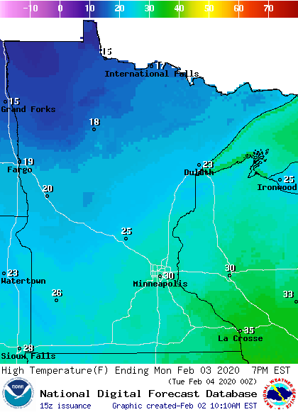
Parts of northwestern Minnesota will have Monday highs in the upper teens.
Twin Cities metro area highs are projected to be around 30 on Monday, then only around 20 on Tuesday, followed by highs in the lower 20s Wednesday and upper 20s Thursday and Friday.
Wind advisories
Wind advisories cover much of northern Minnesota and northwestern Wisconsin this Sunday:
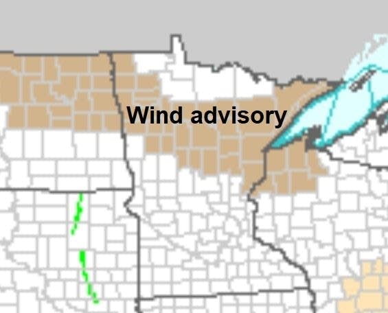
The wind advisory in Thief River Falls, Detroit Lakes and Bemidji runs until noon this Sunday. It runs until 3 p.m. in Brainerd, Hinckley, Hibbing, Duluth and parts of northwestern Wisconsin.
Here are details of the Duluth portion of the wind advisory:
URGENT - WEATHER MESSAGE National Weather Service Duluth MN 707 AM CST Sun Feb 2 2020 ...GUSTY WEST AND NORTHWEST WINDS THIS MORNING AND AFTERNOON... .An area of low pressure will pass over the region this morning and this afternoon. Strong west and northwest winds are expected over central, east-central, and northeast Minnesota and northwest Wisconsin this morning through this afternoon. Sustained winds of 10 to 25 mph are expected with gusts as high as 45 mph. Winds may gust between 50 and 60 mph on the Bong and Blatnik bridges between Duluth and Superior. The winds and gusts will weaken quickly this afternoon as high pressure builds into the region. MNZ037-WIZ001-022100- /O.CON.KDLH.WI.Y.0002.200202T1400Z-200202T2100Z/ Carlton and South St. Louis-Douglas- Including the cities of Duluth and Superior 707 AM CST Sun Feb 2 2020 ...WIND ADVISORY REMAINS IN EFFECT UNTIL 3 PM CST THIS AFTERNOON... * WHAT...Northwest winds 15 to 25 mph with gusts up to 45 mph expected. Wind gusts of 50 to 60 mph are possible on the Bong and Blatnik bridges between Duluth and Superior. * WHERE...In Wisconsin, Douglas County. In Minnesota, Carlton and South St. Louis County. This includes the Tribal Lands of the Fond du Lac Band. * WHEN...Until 3 PM CST this afternoon. * IMPACTS...Gusty winds could blow around unsecured objects. Tree limbs could be blown down and a few power outages may result. PRECAUTIONARY/PREPAREDNESS ACTIONS... Use extra caution when driving, especially if operating a high profile vehicle. Secure outdoor objects.
Here are additional details on the winds today:
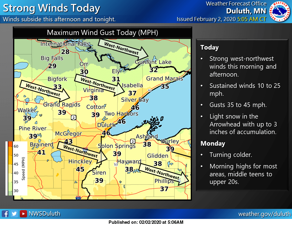
You can hear updated weather information on the MPR network, and you’ll see updated weather info on the MPR News live weather blog.
Programming note
You can hear my live weather updates on MPR News at 7:35 a.m., 9:35 a.m. and 4:35 p.m. each Saturday and Sunday.

