
Heavy snow late tonight into Sunday morning southern Minn.; several inches for the Twin Cities
Twin Cities included in winter storm watch late tonight and Sunday
Go Deeper.
Create an account or log in to save stories.
Like this?
Thanks for liking this story! We have added it to a list of your favorite stories.


Our Saturday will be cooler than normal. Light snow showers are possible in northwestern Minnesota and portions of north-central and northeastern Minnesota.
Southern Minnesota and portions of western Wisconsin are likely to see heavy snow overnight Saturday night and Sunday morning. The Twin Cities metro area will see several inches of snow from the same storm, and the heavy snow band may creep into parts of the metro area. The snow isn’t expected to arrive in the metro area until after midnight Saturday night.
The National Oceanic and Atmospheric Administration’s North American Mesoscale forecast model shows the potential snow pattern Saturday evening through Sunday afternoon:
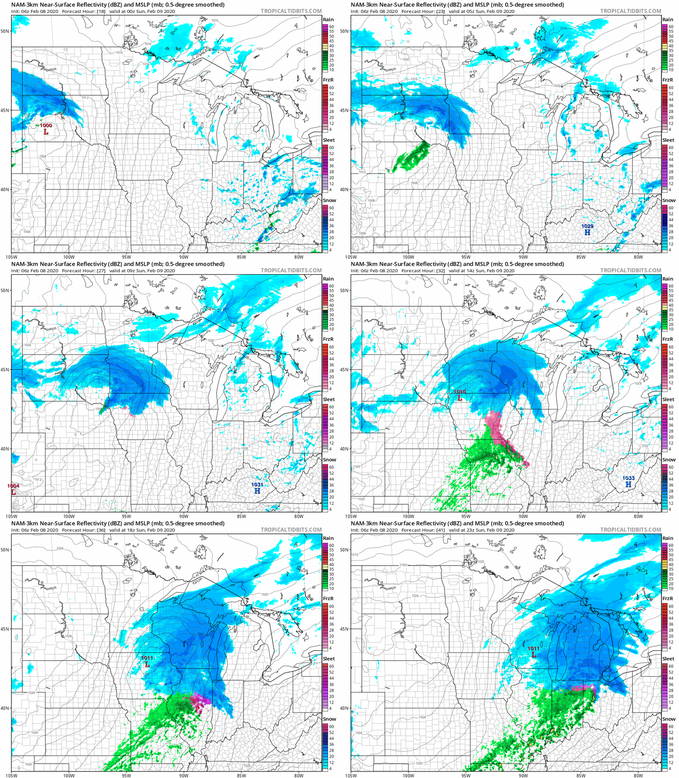
You’ll notice a northward shift of the snow band in this most recent run of the model.
Turn Up Your Support
MPR News helps you turn down the noise and build shared understanding. Turn up your support for this public resource and keep trusted journalism accessible to all.
The heaviest snow band Saturday night and Sunday is expected from southern Minnesota into parts of western Wisconsin:

6 to 8 inches of snow are possible in those areas, with 3 to 6 inches possible in the Twin Cities metro area.
Winter storm warnings start at 9 p.m. in the Marshall area, and at 11 p.m. in the Mankato and Albert Lea areas, then begin at midnight in Rochester and at 3 a.m. Sunday in Eau Claire:

The winter storm watch begins at 1 a.m. in the Twin Cities metro area, and it’s due to the potential of heavier snow if the storm track shifts slightly northward. Here are additional details on this storm:
URGENT - WINTER WEATHER MESSAGE National Weather Service Twin Cities/Chanhassen MN 430 AM CST Sat Feb 8 2020 ...SNOW EXPECTED LATE TONIGHT INTO SUNDAY ACROSS SOUTHERN AND CENTRAL MINNESOTA INTO WISCONSIN... .A Winter Storm Watch has been issued for a couple rows of counties along and north of a line from Canby to Belle Plaine Minnesota through Menomonie to Chippewa Falls Wisconsin from late Saturday night into Sunday. There has been a northern shift in the snow band recently. If this continues, snowfall amounts of 6 inches or greater would be possible in the Watch area. The heaviest snow will be Sunday morning. Meanwhile farther to the south a Winter Storm Warning has been issued. Here confidence is higher in a band of 5 to 8 inches of snow developing later tonight and lasting into Sunday. The heaviest snow will be Sunday morning, with snowfall rates of an inch per hour likely Sunday morning. In addition, northerly wind gusts of 25 to 30 mph will develop Sunday afternoon as the snow tapers off, and this could lead to drifting snow and reduced visibility. There is a winter weather advisory for Martin and Watonwan counties where less snow is expected. The winter storm watch means be prepared, hazardous winter weather is possible. The winter storm warning means please take action such as adjusting travel plans, or allowing extra time for travel. Expect roads to become snow covered and slippery. MNZ059>063-068>070-081830- /O.NEW.KMPX.WS.A.0003.200209T0700Z-200210T0000Z/ Wright-Hennepin-Anoka-Ramsey-Washington-Carver-Scott-Dakota- Including the cities of Monticello, Minneapolis, Blaine, St Paul, Stillwater, Chaska, Shakopee, and Hastings 430 AM CST Sat Feb 8 2020 ...WINTER STORM WATCH IN EFFECT FROM LATE TONIGHT THROUGH SUNDAY AFTERNOON... * WHAT...Heavy snow possible. Total snow accumulations of 2 to 6 inches possible. * WHERE...Portions of central and east central Minnesota. * WHEN...From late tonight through Sunday afternoon. * IMPACTS...Plan on slippery road conditions. PRECAUTIONARY/PREPAREDNESS ACTIONS... Monitor the latest forecasts for updates on this situation.
You can hear updated weather information on the MPR network, and you’ll see updated weather info on the MPR News live weather blog.
Temperature trends
Our average high temp is 27 degrees this time of year in the Twin Cities. We’ll top out around 20 today:
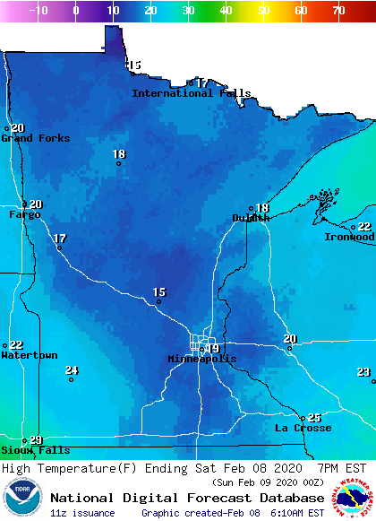
Most of central and northern Minnesota will top out in the teens.
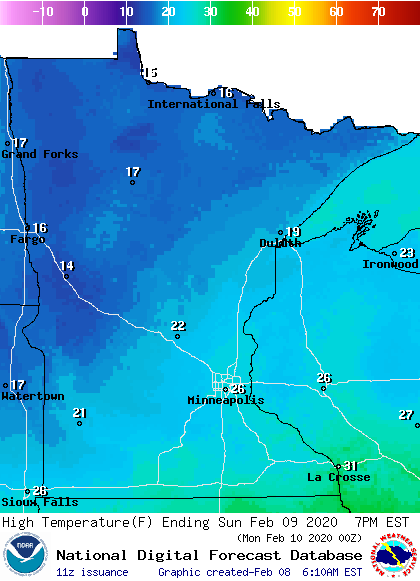
Sunday highs will range from the teens northwest to 20s southeast:
Programming note
You can hear my live weather updates on MPR News at 7:35 a.m., 9:35 a.m. and 4:35 p.m. each Saturday and Sunday.

