
Heavy snow late Saturday night and Sunday morning for south metro, southern Minnesota and western Wisc.
Snow will reduce visibilities and make travel difficult
Go Deeper.
Create an account or log in to save stories.
Like this?
Thanks for liking this story! We have added it to a list of your favorite stories.


The well-advertised weekend snowstorm is expected to lay down a swath of heavy snow across much of the southern third of Minnesota and parts of Wisconsin overnight Saturday night and Sunday morning.
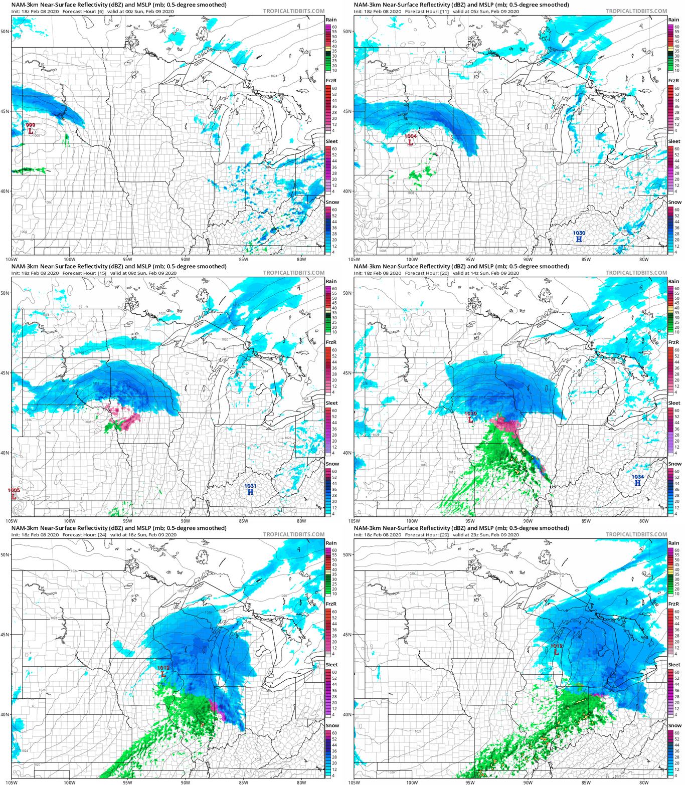
The National Oceanic and Atmospheric Administration’s North American Mesoscale forecast model shows the potential snow pattern Saturday evening through Sunday afternoon:
Here’s the weekend snow forecast that was posted by the National Weather Service late Saturday afternoon:
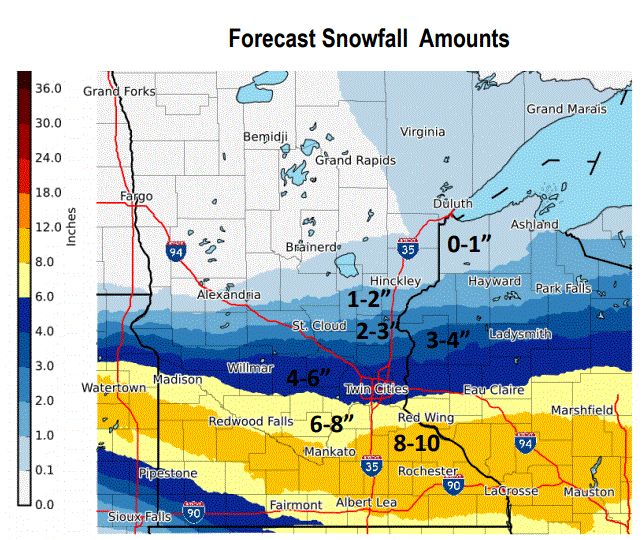
You can see that the southern portion of the Twin Cities metro area may see 6 to 8 inches of snow by Sunday afternoon, with a shot at 9 inches in a few spots. There could be some double-digit snow totals in the heavier snow stripe across southern Minnesota and parts of western Wisconsin.
Turn Up Your Support
MPR News helps you turn down the noise and build shared understanding. Turn up your support for this public resource and keep trusted journalism accessible to all.
Winter storm warnings include Carver, Scott and Dakota counties of the south metro from about midnight Saturday night until mid-afternoon on Sunday:

The remainder of the Twin Cities metro area (including Minneapolis and St. Paul) is under a winter weather advisory from midnight Saturday night to 3 p.m. Sunday for 3 to 6 inches of snow.
You can hear updated weather information on the MPR network, and you’ll see updated weather info on the MPR News live weather blog.
The Minnesota Department of Transportation will have reports on road conditions. Wisconsin road conditions can be found here.
The heaviest snow in the metro area is expected to be from about 4 a.m. to 9 a.m. on Sunday. This NWS chart brackets the times of heaviest snow at various locations:
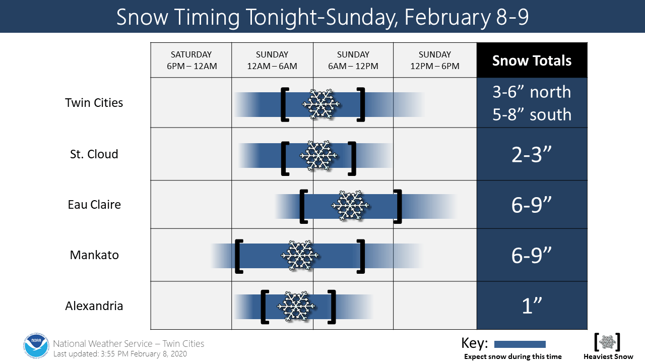
The winter storm warning starts at 9 p.m. Saturday in Montevideo and Marshall, and at 11 p.m. Saturday in Mankato and Albert Lea. The winter storm warning begins at midnight Saturday night in Rochester and Red Wing, and at 3 a.m. Sunday in Eau Claire. The winter storm warnings will continue into early Sunday afternoon in many areas, but they continue until 6 pm Sunday in Red Wing and Rochester, plus Eau Claire and La Crosse.
Here’s a winter storm discussion posted by the NWS:
URGENT - WINTER WEATHER MESSAGE National Weather Service Twin Cities/Chanhassen MN 349 PM CST Sat Feb 8 2020 ...HEAVY SNOW EXPECTED LATE TONIGHT INTO SUNDAY ACROSS SOUTHERN MINNESOTA INTO WISCONSIN... .A Winter Storm Warning has been issued for late tonight and Sunday for much of southern Minnesota into Wisconsin. The warning is in effect along and south of a line from Montevideo to Hutchinson, to the southern suburbs of the Twin Cities, to Chippewa Falls. Snowfall amounts of 5 to 9 inches are expected in the warning area, and the heaviest snow will fall Sunday morning. Meanwhile, farther to the north, a Winter Weather Advisory has been issued for west central Minnesota into east central Minnesota and Wisconsin. The advisory includes Minneapolis and St Paul and northern suburbs. The advisory also covers the area from Morris and Willmar to St Cloud, to New Richmond, Rice Lake and Ladysmith. Totals in this area will vary from two to five inches. The heaviest snow will be Sunday morning, with snowfall rates of an inch per hour likely Sunday morning. In addition, winds will range from 15 to 30 mph in west central and south central Minnesota on Sunday, producing poor visibility in open country. Winds from central Minnesota to the Twin Cities and Wisconsin are expected to be from 10 to 20 mph.
You can hear updated weather information on the MPR network, and you’ll see updated weather info on the MPR News live weather blog.
Updates on the winter storm will be posted by the NWS offices in the Twin Cities, La Crosse and Sioux Falls.
The Minnesota Department of Transportation will have reports on road conditions. Wisconsin road conditions can be found here.
Temperature trends
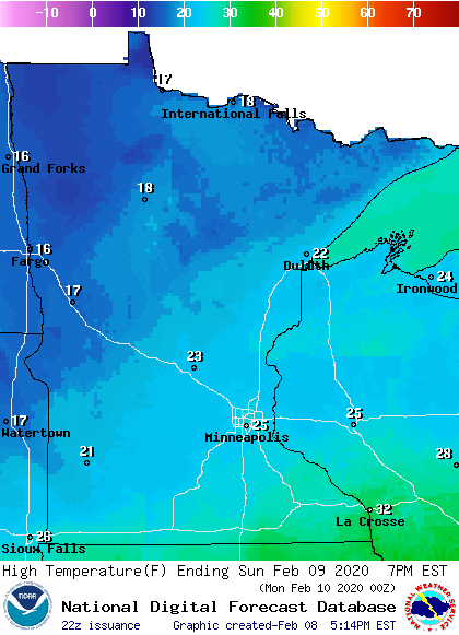
Sunday highs will range from the teens northwest to the 20s southeast:
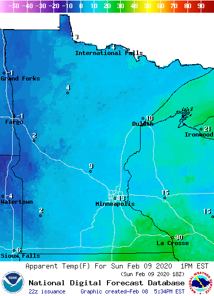
Winds pick up Sunday afternoon, giving us wind chills in the single-digits to teens:
Twin Cities metro area highs are projected to reach the upper 20s Monday and Tuesday, followed by lower 30s Wednesday and chilly upper teens Thursday and Friday.
Programming note
You can hear my live weather updates on MPR News at 7:35 a.m., 9:35 a.m. and 4:35 p.m. each Saturday and Sunday.

