
Sunday snow totals highest to the south; best chance of Monday flakes stays north
Arctic chill later this week
Go Deeper.
Create an account or log in to save stories.
Like this?
Thanks for liking this story! We have added it to a list of your favorite stories.


Some people take their snow measurements later in the day, so all the weekend snow reports aren’t in yet. The highest weekend snow total that I’ve seen so far is 15.5 inches in Lake Crystal, which is a few miles west-southwest of Mankato:
Let’s give the preliminary golden shovel award to Lake Crystal, pending possible snowfall reports that might drift in Sunday evening or early on Monday.
A county by county snowfall listing can be found here.
Turn Up Your Support
MPR News helps you turn down the noise and build shared understanding. Turn up your support for this public resource and keep trusted journalism accessible to all.
The official Sunday morning snow total at Minneapolis-St. Paul International Airport was 4.8 inches, which is the highest single-day total there since Dec. 30. I had 6 inches of new snow in St. Paul Sunday morning and I also saw a 6 inch snow total from Minneapolis. Metro area snow amounts were the lowest in far northern Anoka county, where some spots had only a couple of inches of new snow. Most of the Twin Cities metro area tallied between 4 and 7 inches of snow from this storm, but I did see a 7.5 inch report in Bloomington and 7.3 inches in Shakopee and Savage. Jordan and Lakeville had 7 inches of new snow on Sunday.
As expected, the highest snow totals from Saturday night through Sunday were in southern Minnesota. Other than the 15.5 inches in Lake Crystal, there were many additional double-digit totals in southern Minnesota. Here are a few of them: 12.5 in St. James and 11 inches in New Ulm and Marshall. Owatonna had 10.3 inches and Rochester 10 inches. Menomonie,in west-central Wisconsin, reported 8.2 inches…but their final tally may be a bit higher.
You can look at snow reports that have been posted by the National Weather Service here. This is how the snow report map looked late on Sunday:

You can click on any report on the NWS site (or hover over it) to get the snow amount, the exact location and the time of the snow measurement. Be aware of the observation time; a snow measurement taken at 6 a.m. would not include the heavier snow that fell in many locations around mid morning, and sometimes the observer either doesn’t take another measurement or takes a second measurement much later in the day. If you go to the NWS site Monday morning, move the slider in the upper left to 36 hours to include reports from early Sunday.
If you’re wondering the status of roads for Sunday night or Monday morning travel, the Minnesota Department of Transportation will have reports on road conditions. Wisconsin road conditions can be found here.
Monday snow chances
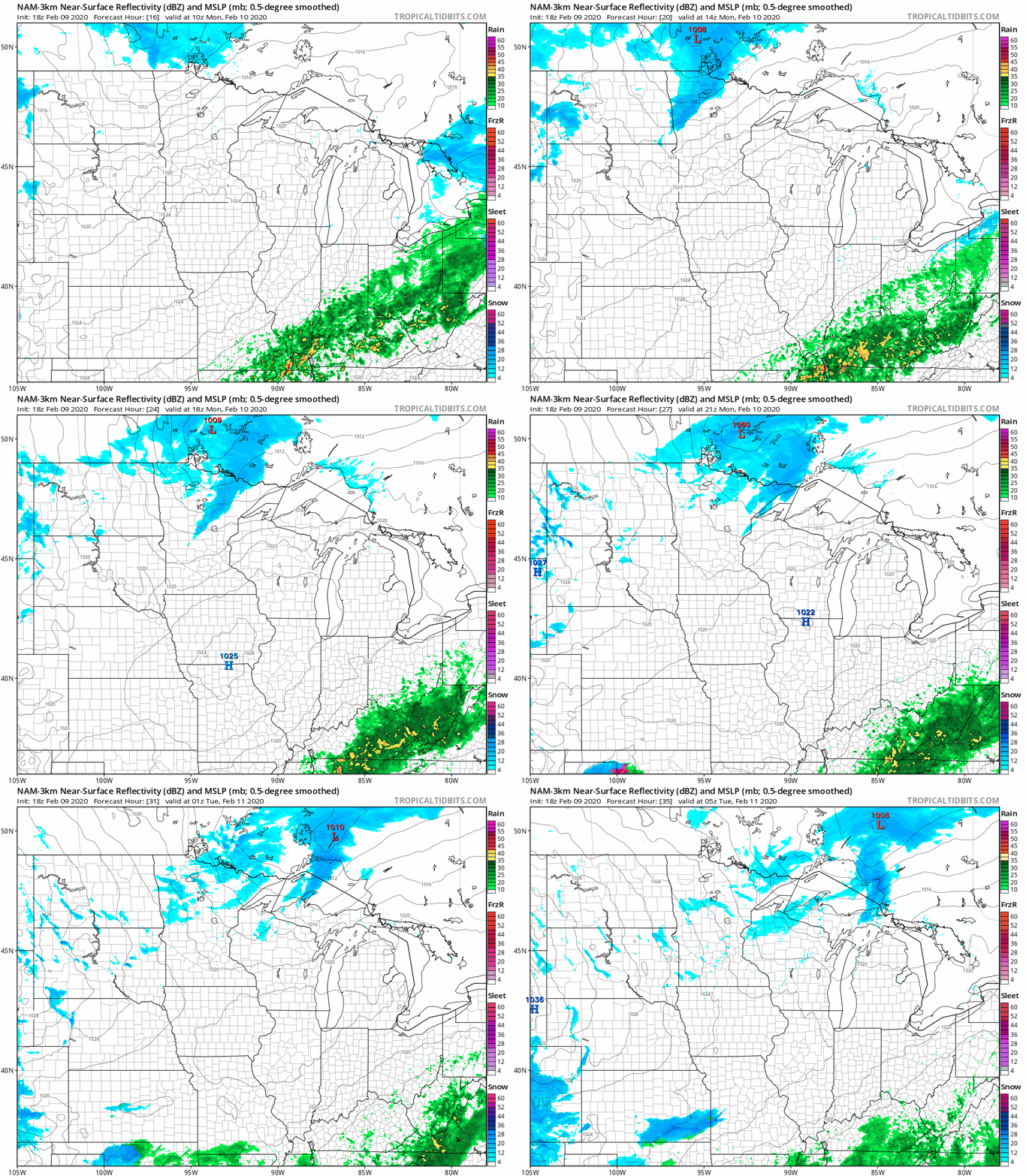
Northern Minnesota will see some periods of light snow on Monday, and central Minnesota and the metro area could see a passing afternoon or evening flurry.
The National Oceanic and Atmospheric Administration’s North American Mesoscale forecast model shows the potential snow pattern Monday through Monday evening:
You can hear updated weather information on the MPR network, and you’ll see updated weather info on the MPR News live weather blog.
Much colder late in the week
Minnesota and western Wisconsin highs will be mostly in the 20s on Monday, with some spots in southern Minnesota reaching the lower 30s:
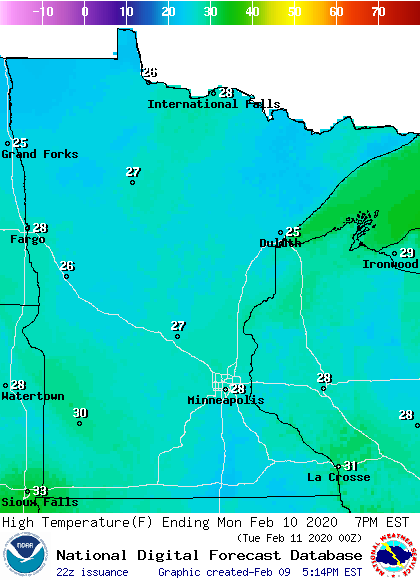
Some spots in the Twin Cities metro area could touch 30 Monday afternoon.
Twin Cities highs are projected to reach the upper 20s Tuesday, followed by lower 30s on Wednesday. Then it will turn much colder, with Twin Cities highs in the lower teens Thursday and upper teens on Friday.
Some spots in northern and western Minnesota will have highs near zero on Thursday.
NWS 150 years old
The birth of what we now call the National Weather Service occurred 150 years ago:
Happy anniversary!

