
Saturday will be breezy and warmer
Deepest snow cover to the north
Go Deeper.
Create an account or log in to save stories.
Like this?
Thanks for liking this story! We have added it to a list of your favorite stories.


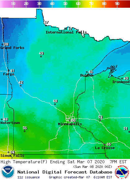
Our average Twin Cities high temp is 37 degrees this time of year. We’ll top out in the 50s Saturday afternoon. Most of the southern third of Minnesota plus western Wisconsin will reach the 50s:
It’ll be breezy Saturday afternoon, with gusts over 20 mph at times:
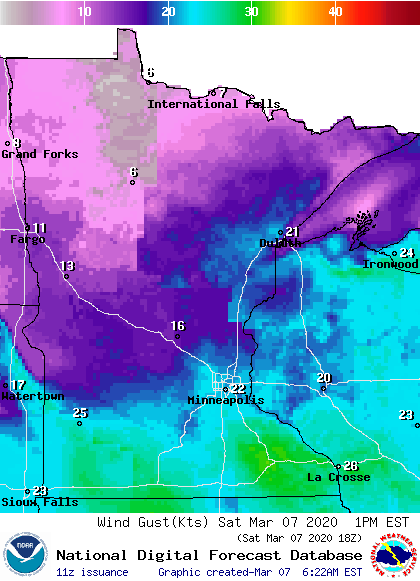
Forecasts are in knots, 20 knots equals 23 mph.
Snow depths
Turn Up Your Support
MPR News helps you turn down the noise and build shared understanding. Turn up your support for this public resource and keep trusted journalism accessible to all.
Cross-country skiers, sledders, snowboarders and snowmobilers will find the deepest snow cover this weekend over northern parts of Minnesota and Wisconsin.
Here’s the latest snow depth analysis from NOAA’s National Operational Hydrologic Remote Sensing Center. (NOHRSC):

Much of north-central and northeastern Minnesota has more than 16 inches of snow on the ground, and some spots in the northeast show more than 30 inches. The snow cover will shrink a bit this weekend, due to our warming trend. Snow cover is more variable in southern Minnesota, ranging from zero in some areas to several inches in other areas.
The NWS lists the Twin Cities snow depth as just a trace of snow Saturday morning. I’ve noticed that many south-facing lawns in the metro area have little or no snow cover, while some snow remains on north-facing slopes and shaded areas.
An updated Updraft with details about the remainder of this weekend and the coming week will be posted by 9:30 this morning.
Programming note
You can hear my live weather updates on MPR News at 7:35 a.m., 9:35 a.m. and 4:35 p.m. each Saturday and Sunday.

