
Warm Sunday breezes; many 50s and 60s in Minnesota and western Wisconsin
Temps retreat on Monday, with rain chances in some areas
Go Deeper.
Create an account or log in to save stories.
Like this?
Thanks for liking this story! We have added it to a list of your favorite stories.


It’ll feel more like May than March today. Our average high temperature is 37 degrees this time of year in the Twin Cities. We’ll be way warmer than that this Sunday, with highs in the mid to upper 60s.
We’ll share highs in the 60s with most of the southern half of Minnesota plus parts of western Wisconsin. A few spots in southwestern Minnesota may touch 70. Highs in the 50s are on tap for much of central Minnesota, with highs in the 40s in far northern Minnesota. A few spots in the northwestern corner of Minnesota may top out in the upper 30s. It’ll be breezy in many areas.
Temperature trends
Our Monday highs may occur around 1 a.m. in the Twin Cities, with temps falling by sunrise on Monday, then rebounding a bit Monday afternoon.
Turn Up Your Support
MPR News helps you turn down the noise and build shared understanding. Turn up your support for this public resource and keep trusted journalism accessible to all.
Here are the forecast highs for the daylight hours of Monday:
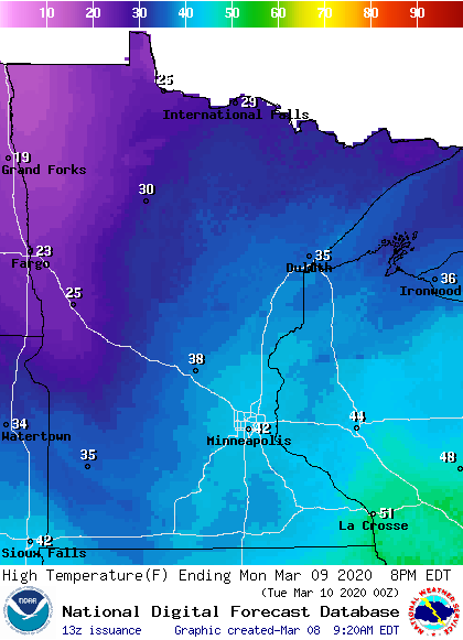
Twin Cities metro area highs are projected to reach the lower 40s Tuesday, followed by upper 40s Wednesday and Thursday and mid 40s on Friday.
Precipitation chances
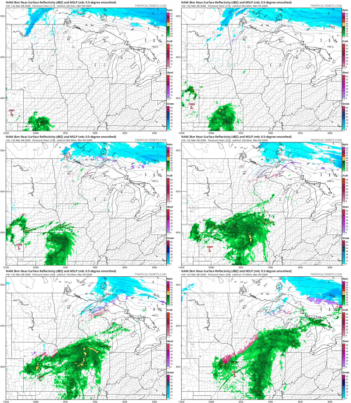
Far northwestern Minnesota may see some areas of drizzle and a few stray flakes late Sunday afternoon. Patchy drizzle/freezing drizzle and a few flakes are possible in far northern Minnesota overnight Sunday night, and that combo could linger in northeastern Minnesota and parts of northwestern Wisconsin Monday morning. Southeastern Minnesota and southwestern Wisconsin will probably have rain showers at times late Sunday night and Monday.
The National Oceanic and Atmospheric Administration’s North American Mesoscale forecast model shows the potential precipitation pattern for Sunday evening through Monday morning:
You can hear updated weather information on the MPR network, and you’ll see updated weather info on the MPR News live weather blog.
Snow depths

The National Weather Service lists the Twin Cities snow depth Sunday morning as just a trace of snow. I’ve noticed that many south-facing lawns and open spots in the metro area have little or no snow cover, while a few inches of snow remain on some north-facing slopes and shaded areas.
Cross-country skiers, sledders, snowboarders and snowmobilers will find the deepest snow cover this Sunday over northern parts of Minnesota and Wisconsin. Here’s the latest snow depth analysis from NOAA’s National Operational Hydrologic Remote Sensing Center. (NOHRSC):

Much of north-central and northeastern Minnesota has more than 16 inches of snow on the ground, and some spots in the northeast show more than 30 inches. The snow cover will shrink a bit today due to the unusually warm temps. Snow cover is more variable in southern Minnesota, ranging from zero in some areas to several inches in other areas.
Flooding along some rivers
There are flood warnings along portions of some rivers in southwestern Minnesota. Areas affected are shaded green in this NWS map:

You can go the the NWS site and click on your any green-shaded area for flood warning details.
Here’s the flood statement that was issued by the NWS Saturday evening:
Flood Statement National Weather Service Twin Cities/Chanhassen MN 802 PM CST Sat Mar 7 2020 ...The flood warning continues for the following rivers in Minnesota... Cottonwood River at New Ulm affecting Brown County Minnesota River At Morton affecting Redwood and Renville Counties Redwood River near Redwood Falls affecting Redwood County ...The flood warning continues for the following rivers in Minnesota.. Cottonwood River Above Springfield affecting Brown County .Overview...Snowmelt combined with ice jamming has created flooding conditions along the Cottonwood River. With a few days of significant warmth expected, this could possibly break up the jam and cause further flooding along the Cottonwood, Minnesota, and other rivers. PRECAUTIONARY/PREPAREDNESS ACTIONS... Do not drive cars through flooded areas. Turn Around...Don`t Drown. Stay tuned to NOAA Weather Radio or your local radio or TV station for the latest information concerning this flood event.
Programming note
You can hear my live weather updates on MPR News at 7:35 a.m., 9:35 a.m. and 4:35 p.m. each Saturday and Sunday.

