
Weekend forecast plus an update on Thursday rain, wind and snow
Thunder chance in far southern Minnesota Thursday afternoon
Go Deeper.
Create an account or log in to save stories.
Like this?
Thanks for liking this story! We have added it to a list of your favorite stories.


I’ll get to the weekend forecast shortly, but let’s start with details about our Thursday afternoon and evening combo of rain, snow and strong winds.
Soaking rains are expected this Thursday afternoon across much of the southern half of Minnesota and western Wisconsin. The rain is expected to transition to wet snow from west to east as we go through the afternoon and into the evening.
The National Oceanic and Atmospheric Administration’s North American Mesoscale forecast model shows the potential precipitation pattern Thursday afternoon through Thursday night:
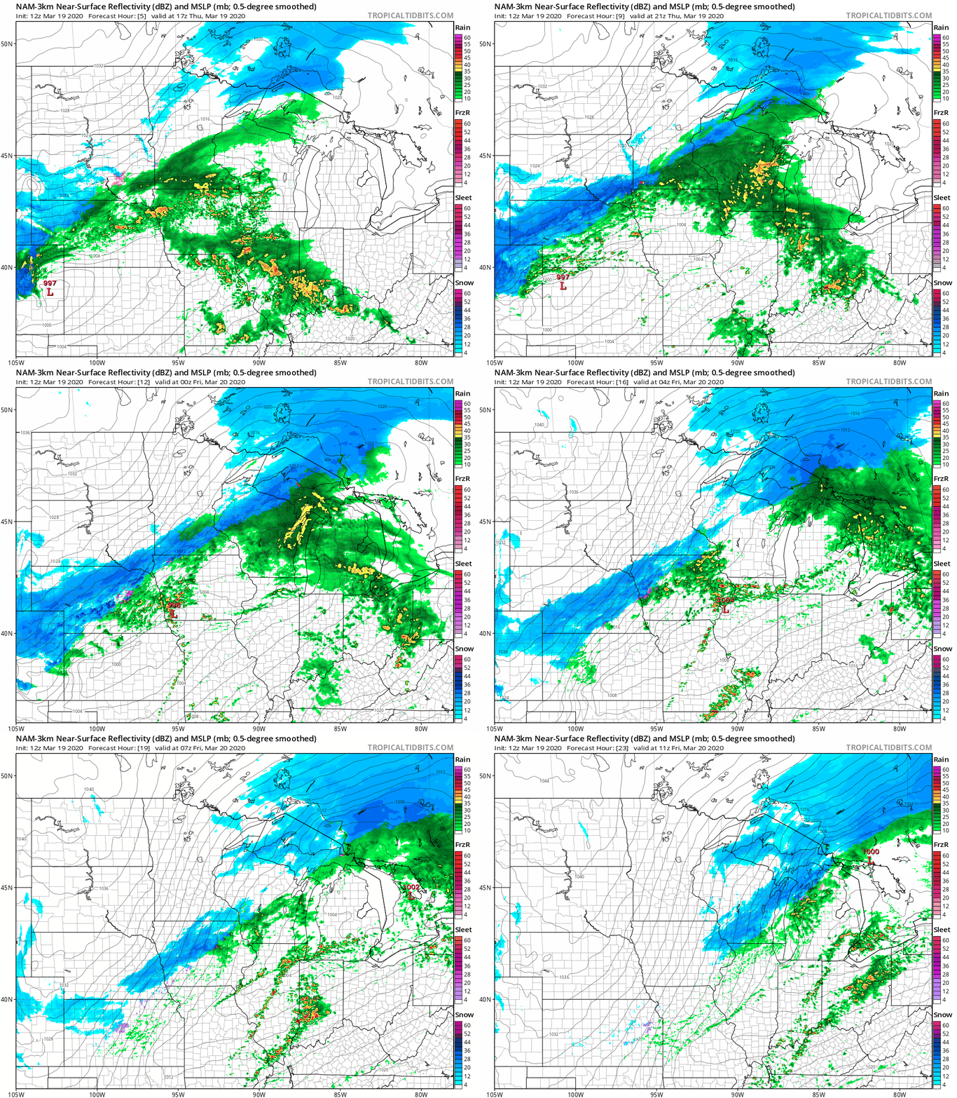
The Twin Cities metro area will see mainly rain Thursday afternoon, then an evening transition to a rain/snow mix and eventually all snow. With that timeline, most of the metro area would see less than one inch of snow. Check for updates.
Turn Up Your Support
MPR News helps you turn down the noise and build shared understanding. Turn up your support for this public resource and keep trusted journalism accessible to all.
The changeover to a rain/snow mix and then snow happens earlier in southwestern Minnesota. Snow amounts of 1-2 inches are possible in southwestern Minnesota and elsewhere in far southern Minnesota before it ends:
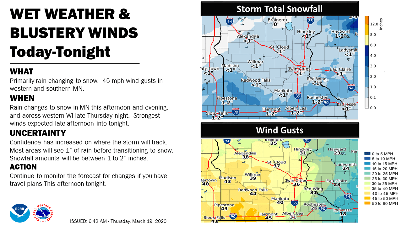
Winds gusts over 40 mph are expected Thursday afternoon and evening in parts of western Minnesota. Wind advisories cover west-central Minnesota and parts of southwestern Minnesota Thursday afternoon and evening:
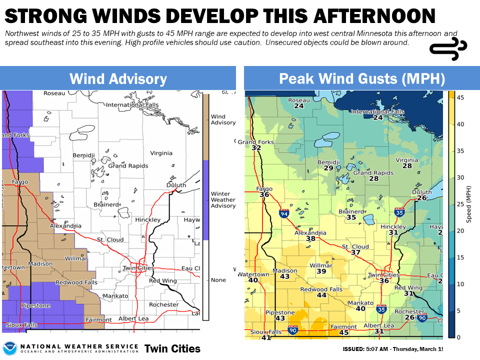
Far southwestern Minnesota is in a winter weather advisory Thursday afternoon and evening for a combination of snow and strong winds:
“URGENT - WINTER WEATHER MESSAGE National Weather Service Sioux Falls SD 328 AM CDT Thu Mar 19 2020 MNZ071-072-080-097-098-SDZ040-050-053>056-058>070-191630- /O.CON.KFSD.WW.Y.0016.200319T1800Z-200320T0600Z/ Lincoln-Lyon-Murray-Pipestone-Rock-Brookings-Gregory-Sanborn- Miner-Lake-Moody-Aurora-Davison-Hanson-McCook-Minnehaha- Charles Mix-Douglas-Hutchinson-Turner-Bon Homme-Yankton-Clay- 328 AM CDT Thu Mar 19 2020 ...WINTER WEATHER ADVISORY REMAINS IN EFFECT FROM 1 PM THIS AFTERNOON TO 1 AM CDT FRIDAY... * WHAT...Snow expected. Total snow accumulations of up to two inches. Winds gusting as high as 45 mph. * WHERE...Portions of east central, south central and southeast South Dakota and southwest Minnesota. * WHEN...From 1 PM this afternoon to 1 AM CDT Friday. * IMPACTS...Plan on slippery road conditions. Patchy blowing snow could significantly reduce visibility. The hazardous conditions could impact the evening commute. * ADDITIONAL DETAILS...Falling temperatures late this afternoon and evening may result in a refreeze of wet pavement and slick conditions. PRECAUTIONARY/PREPAREDNESS ACTIONS... Slow down and use caution while traveling. The latest road conditions for the state you are calling from can be obtained by calling 5 1 1.”
Northwestern Minnesota counties that border the Red River are in a winter weather advisory Thursday afternoon and evening for blowing snow and severely reduced visibilities as winds gust as high as 45 mph.
Parts of far southern Minnesota will have a thunderstorm chance this Thursday afternoon/early evening. The Storm Prediction Center of the National Weather Service even shows a marginal risk of a severe thunderstorm in a tiny portion of far southeastern Minnesota into southwestern Wisconsin:
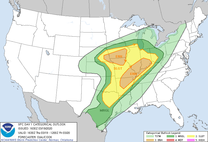
A marginal risk means that an isolated severe thunderstorm is possible. Portions of Iowa have an enhanced risk of severe weather Thursday afternoon into Thursday night.
You can hear updated weather information on the MPR network, and you’ll see updated weather info on the MPR News live weather blog.
The weekend
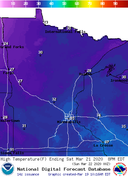
Our average Twin Cities high temperature is 44 degrees on March 21. We’ll probably top out in the mid 30s this Saturday in the metro area. Most of Minnesota will see Saturday highs in the 30s, with a sprinkling of upper 20s in parts of the north:
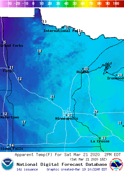
Saturday afternoon wind chills will be in the teens in the west, with 20s across much of eastern Minnesota and western Wisconsin:
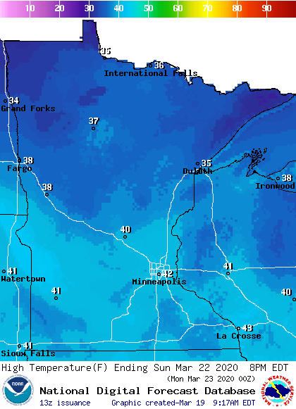
Sunday high temps reach the 40s south and the 30s north:
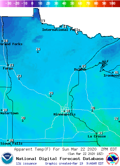
Sunday afternoon wind chills will be in the 20s in many areas, with lower 30s far south:
Saturday looks dry. There could be a few scattered rain/snow showers on Sunday.
Snow depths
There’s still some snow on the ground across northern Minnesota and far northern Wisconsin. Here’s the latest snow depth analysis from NOAA’s National Operational Hydrologic Remote Sensing Center. (NOHRSC):

Portions of northeastern Minnesota still have over 20 inches of snow on the ground.
I’m sure that some cross-country skiers, sledders, snowboarders and snowmobilers will take advantage of that snow cover during this first weekend of spring.

