
Rain, ice and snow spread across Minnesota Thursday into Friday; the weekend looks quiet
Wintry mix holds off until late Thursday night or early Friday in the Twin Cities
Go Deeper.
Create an account or log in to save stories.
Like this?
Thanks for liking this story! We have added it to a list of your favorite stories.


The hazardous travel weather this Thursday will be concentrated in northwestern Minnesota and parts of west-central Minnesota. Those areas will see a mixture of sleet, light freezing rain and snow. Southwestern Minnesota may see a wintry mix by late Thursday afternoon or Thursday evening. The wintry mix- to- snow combo will spread to the east and southeast Thursday night into Friday.
The National Oceanic and Atmospheric Administration’s North American Mesoscale forecast model shows the potential precipitation pattern Thursday afternoon through Friday afternoon:
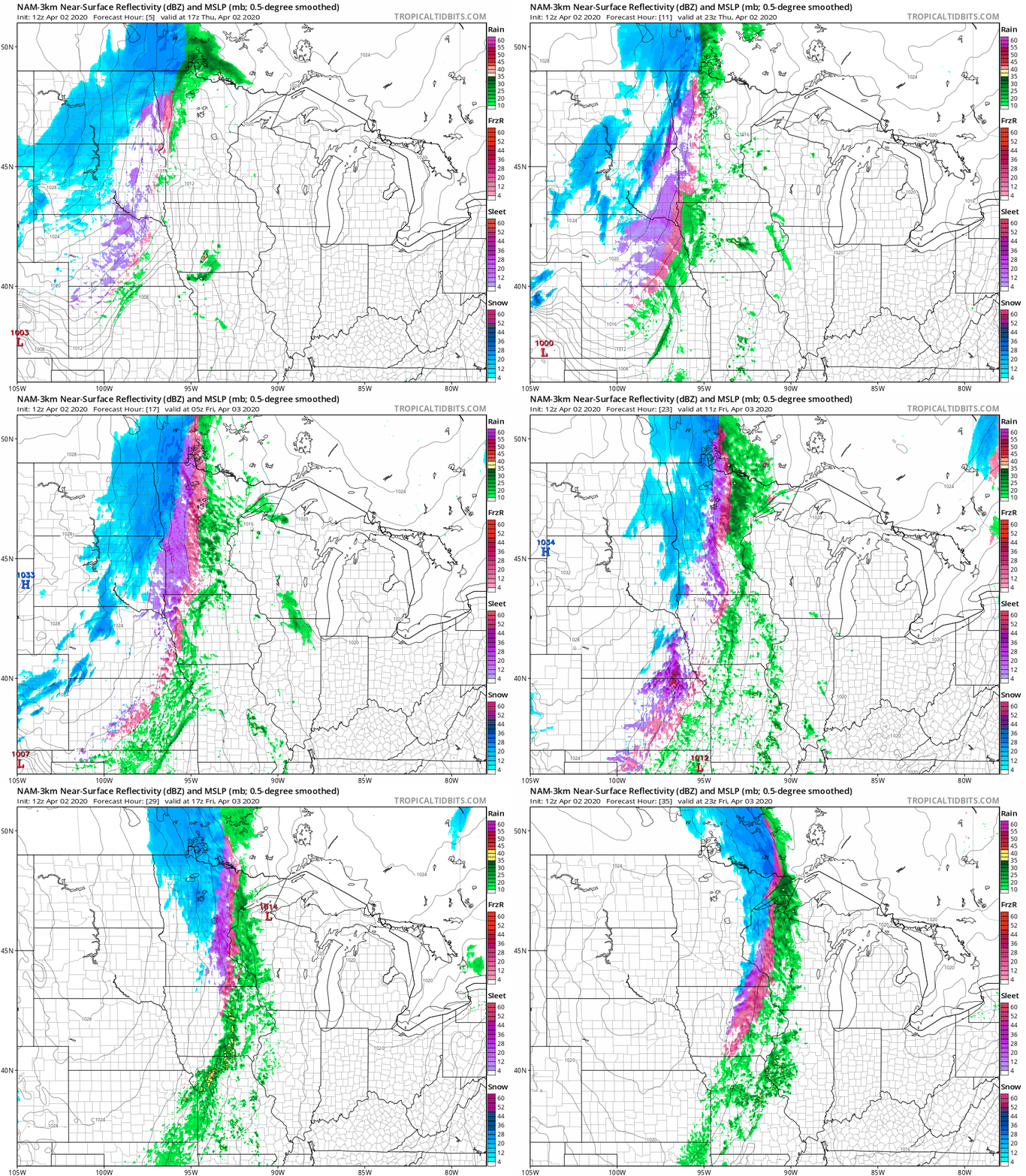
The Twin Cities metro area could see scattered rain showers Thursday afternoon, with some periods of rain likely Thursday evening.The chance of sleet/light freezing rain and snow arrives Friday morning in the metro area.
Warnings and advisories
Winter storm warnings (in pink) cover much of northwestern Minnesota from Thursday afternoon into Friday afternoon:
Turn Up Your Support
MPR News helps you turn down the noise and build shared understanding. Turn up your support for this public resource and keep trusted journalism accessible to all.

Winter weather advisories (blue) begin at 7 p.m. in Bemidji and at midnight Thursday night in Brainerd and International Falls.
Here are details on the winter storm warning in northwestern Minnesota:
URGENT - WINTER WEATHER MESSAGE National Weather Service Grand Forks ND 404 AM CDT Thu Apr 2 2020 MNZ002-003-005-008-013>015-022-027-029-030-040-NDZ053-040000- /O.CON.KFGF.WS.W.0002.200402T1800Z-200404T0000Z/ Norman-Clay-Roseau-East Marshall-Pennington-Red Lake-East Polk- Mahnomen-West Becker-Wilkin-West Otter Tail-Grant-Richland- Including the cities of Ada, Twin Valley, Halstad, Moorhead, Roseau, Warroad, Greenbush, Newfolden, Middle River, Grygla, Thief River Falls, Red Lake Falls, Fosston, Fertile, McIntosh, Erskine, Mahnomen, Naytahwaush, Waubun, Detroit Lakes, Breckenridge, Fergus Falls, Elbow Lake, Hoffman, Ashby, Herman, Barrett, and Wahpeton 404 AM CDT Thu Apr 2 2020 ...WINTER STORM WARNING REMAINS IN EFFECT FROM 1 PM THIS AFTERNOON TO 7 PM CDT FRIDAY... * WHAT...Snow and a wintry mix expected. Total snow accumulations of 2 to 5 inches and ice accumulations of up to one tenth of an inch. * WHERE...Mahnomen, West Becker, West Otter Tail and Grant Counties. * WHEN...From 1 PM Thursday to 7 PM CDT Friday. * IMPACTS...Travel will be very difficult. The hazardous conditions will impact the morning and evening commute. PRECAUTIONARY/PREPAREDNESS ACTIONS... If you must travel, keep an extra flashlight, food, and water in your vehicle in case of an emergency. The latest road conditions for North Dakota can be found at dot.nd.gov/travel and for Minnesota at 511mn.org, or by calling 5 1 1 in either state.
Parts of northwestern Minnesota could see 6 to 8 inches of snow by Friday afternoon:

Winter weather advisories expand into central Minnesota later Thursday night and into the western part of the Twin Cities metro area by Friday morning:

Here are details:
URGENT - WINTER WEATHER MESSAGE National Weather Service Twin Cities/Chanhassen MN 335 AM CDT Thu Apr 2 2020 ...FREEZING RAIN...SLEET...AND SNOW WILL SPREAD EAST ACROSS MINNESOTA THIS EVENING THROUGH FRIDAY... .Rain will continue through most of today across western Minnesota before a cold front pushes through. Temperatures will rapidly fall below freezing behind the front which will turn the rain to freezing rain, then sleet, and eventually snow. The rain to wintry mix transition will occur steadily from west to east tonight, reaching eastern Minnesota by early Friday morning. Ice accumulation of one to two tenths of an inch and snow accumulation of an inch or less are expected in the Winter Weather Advisory area. The advisory is in effect west of a line from Mille Lacs Lake, to the western Twin Cities suburbs, to Faribault and Albert Lea. MNZ044-050-051-059-066>069-075>077-083>085-092-093-022030- /O.NEW.KMPX.WW.Y.0013.200403T1000Z-200403T2100Z/ Mille Lacs-Benton-Sherburne-Wright-McLeod-Sibley-Carver-Scott- Nicollet-Le Sueur-Rice-Blue Earth-Waseca-Steele-Faribault- Freeborn- Including the cities of Princeton, Sauk Rapids, Elk River, Monticello, Hutchinson, Gaylord, Chanhassen, Chaska, Victoria, Shakopee, St Peter, Le Sueur, Faribault, Mankato, Waseca, Owatonna, Blue Earth, and Albert Lea 335 AM CDT Thu Apr 2 2020 ...WINTER WEATHER ADVISORY IN EFFECT FROM 5 AM TO 4 PM CDT FRIDAY... * WHAT...Mixed precipitation expected. Total snow accumulations of up to one inch and ice accumulations of around a tenth of an inch. * WHERE...Portions of central, east central and south central Minnesota. * WHEN...From 5 AM to 4 PM CDT Friday. * IMPACTS...Plan on slippery road conditions and isolated power outages. PRECAUTIONARY/PREPAREDNESS ACTIONS... Slow down and use caution while traveling. The latest road conditions for the state you are calling from can be obtained by calling 5 1 1.
Here’s a look at snow and ice potential for Thursday and Friday combined:

In most of eastern Minnesota, the snow and ice are expected to hold off until Friday.
You can hear updated weather information on the MPR network, and you’ll see updated weather info on the MPR News live weather blog.
What about the weekend?
Forecast models show dry weather Saturday and Sunday across most of Minnesota plus western Wisconsin. Northern Minnesota could see a few scattered showers late on Sunday.
Saturday highs range from the 30s in far northwestern Minnesota to around 50 in the far southeast corner:
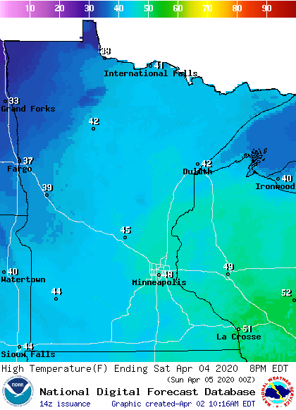
There’ll be plenty of sunshine on Saturday, and winds will be light. It’ll be good weather for a walk, jog or bicycle ride as we continue to practice social-distancing.
Sunday highs will be in the 50s in many areas, with some 40s in roughly the northern third of Minnesota:
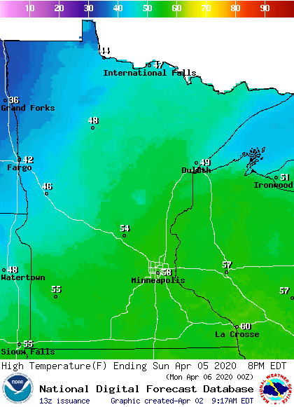
Breezes will be light in most areas on Sunday.

