
Wintry mix update; weekend weather looks pleasant
Impressive snow totals in northwestern Minnesota
Go Deeper.
Create an account or log in to save stories.
Like this?
Thanks for liking this story! We have added it to a list of your favorite stories.


Sometimes we hit a speed bump on our journey through spring. Freezing drizzle and light freezing rain left an icy glaze in many areas this morning, including the Twin Cities. Many areas will see some additional icing Friday afternoon.
In parts of northwestern Minnesota, this same storm system dumped plowable snow amounts Thursday and Thursday evening.
Here’s what MPR News correspondent Dan Gunderson saw Friday in Moorhead, Minn:
The National Weather Service snowfall map shows substantial Thursday snow totals in parts of northwestern Minnesota and eastern North Dakota:
Turn Up Your Support
MPR News helps you turn down the noise and build shared understanding. Turn up your support for this public resource and keep trusted journalism accessible to all.

Greenbush, Minn., reported 11 inches of new snow. You can hover over any snow report on the NWS site for details on the exact snow amount plus the exact location and time of the snow measurement.
Friday wintry mix update
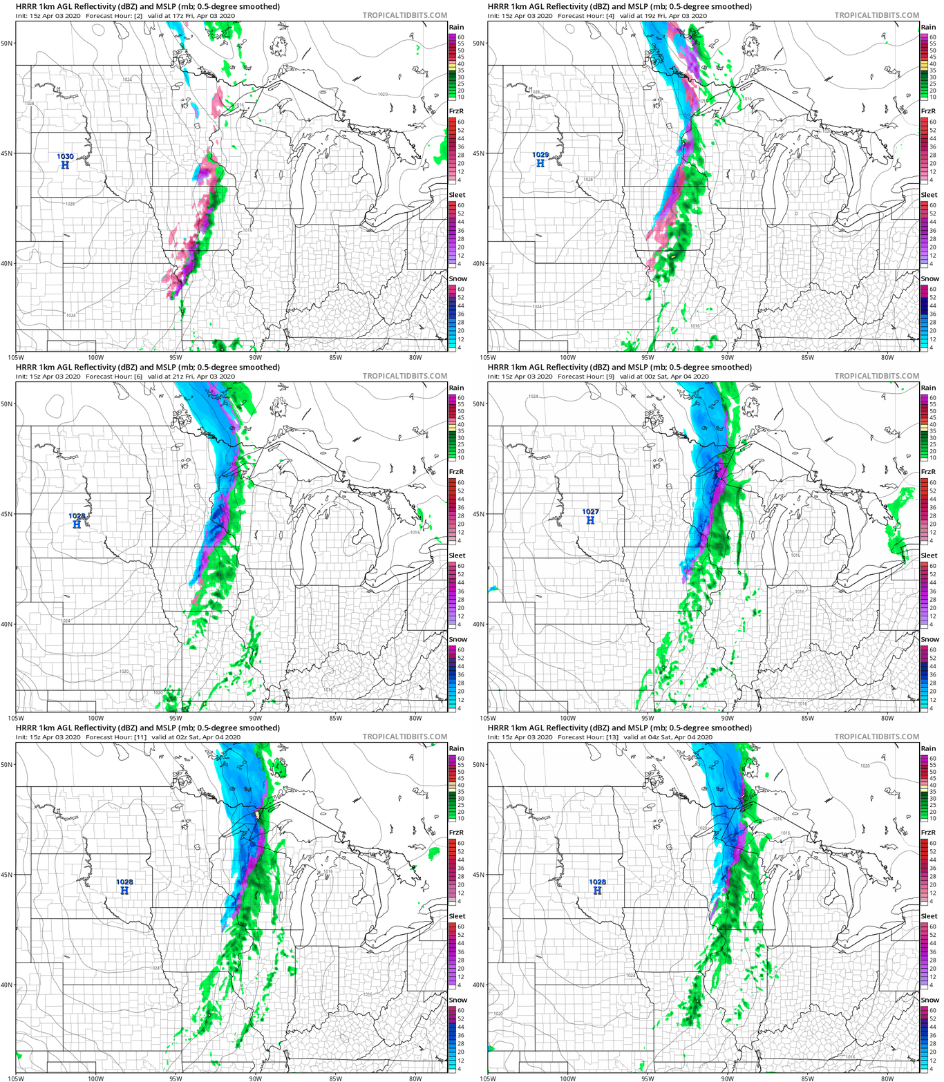
A mix of light freezing rain, sleet and snow continues into Friday afternoon in much of eastern Minnesota and western Wisconsin. The wintry mix may linger into Friday evening in the far northeastern corner and far southeastern corner of Minnesota, plus western Wisconsin.
The National Oceanic and Atmospheric Administration’s High Resolution Rapid-Refresh (HRRR) forecast model shows the potential precipitation pattern Friday afternoon and Friday evening:
Winter weather advisories (shaded blue) continue in much of eastern Minnesota and western Wisconsin this Friday afternoon:

The winter weather advisory in west-central Wisconsin and in far southeastern Minnesota continues until 7 p.m. Friday.
Here are details of the winter weather advisory that includes most of the Twin Cities metro area until 4 p.m.:
URGENT - WINTER WEATHER MESSAGE National Weather Service Twin Cities/Chanhassen MN 1147 AM CDT Fri Apr 3 2020 ...WINTRY MIX CONTINUES TODAY... .Precipitation this morning is expanding along and east of the Interstate 35 corridor in Minnesota. Through noon, this will be a mix of freezing rain sleet that will transition to sleet and snow. It will become all snow in western Wisconsin this afternoon. Ice accumulations up to a tenth of an inch is expected, with 1 to 2 inches of snow possible in western Wisconsin. The Winter Weather Advisory is in effect across eastern Minnesota and western Wisconsin. MNZ052-053-060>063-069-070-076>078-084-085-093-032100- /O.CON.KMPX.WW.Y.0013.000000T0000Z-200403T2100Z/ Isanti-Chisago-Hennepin-Anoka-Ramsey-Washington-Scott-Dakota- Le Sueur-Rice-Goodhue-Waseca-Steele-Freeborn- Including the cities of Cambridge, Center City, Minneapolis, Blaine, St Paul, Stillwater, Shakopee, Hastings, Le Sueur, Faribault, Red Wing, Waseca, Owatonna, and Albert Lea 1147 AM CDT Fri Apr 3 2020 ...WINTER WEATHER ADVISORY REMAINS IN EFFECT UNTIL 4 PM CDT THIS AFTERNOON... * WHAT...Mixed precipitation. Additional snow accumulations of up to one inch and ice accumulations of a light glaze. * WHERE...Portions of east central, south central and southeast Minnesota. * WHEN...Until 4 PM CDT this afternoon. * IMPACTS...Plan on slippery road conditions. . PRECAUTIONARY/PREPAREDNESS ACTIONS... Slow down and use caution while traveling. The latest road conditions for the state you are calling from can be obtained by calling 5 1 1.
You can hear updated weather information on the MPR network, and you’ll see updated weather info on the MPR News live weather blog.
The weekend
This weekend is expected to be dry during the daylight hours across most of Minnesota and western Wisconsin. A few scattered showers are possible Sunday evening and Sunday night.
There will be plenty of sunshine on Saturday, and winds will be very light. Saturday highs reach the 40s in most locations:
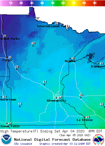
The far northwest will see some 30s.
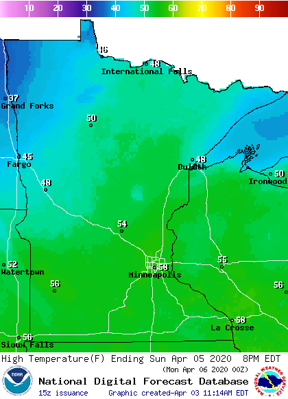
Sunday highs reach the 40s in the far north, with 50s across the rest of Minnesota plus western Wisconsin:
Sunday afternoon will feature wind gusts of 12-18 mph:
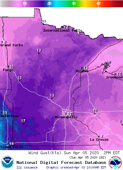
Gusts are plotted in knots, with 12 knots equal to around 14 mph.
Our weekend weather will be good for a walk, jog or bicycle ride as we continue to practice social-distancing.

