
Quiet weather Friday before a major storm Easter Sunday
Much colder temperatures ahead next week
Go Deeper.
Create an account or log in to save stories.
Like this?
Thanks for liking this story! We have added it to a list of your favorite stories.


Friday will be comfortable with milder temperatures and more sunshine. Then a strong storm brings a wintry mix and much colder weather by Sunday.
Friday and Saturday
Friday started off with almost the entire state in the 20s. Temperatures the rest of the day will be noticeably milder than Thursday, with highs in the upper 40s for northern Minnesota and 50s south.

Winds have died down significantly since Thursday, so there is also less of a wind chill, making Friday feel much more comfortable.
Dry skies prevail, and although it is mostly cloudy, there will still be plenty of breaks of sunshine. Weather conditions will be similar on Saturday, and even a few degrees warmer in southern Minnesota.
Turn Up Your Support
MPR News helps you turn down the noise and build shared understanding. Turn up your support for this public resource and keep trusted journalism accessible to all.
Light rain and snow then starts pushing into southern Minnesota Saturday afternoon and evening ahead of a strong storm that brings major impacts Minnesota on Sunday.
A major storm for Easter
A massive spring storm will affect much of the United Stated on Sunday, bringing everything from heavy snow to areas including the Great Plains to a tornado risk for states near the Gulf Coast.

Minnesota will fall on the northern fringe of the storm. Because of the storm’s placement and track, northwestern Minnesota could escape seeing any precipitation, while southeastern Minnesota is likely to see the heaviest precipitation.
The storm will bring rain switching to mostly snow for much of southern Minnesota on Sunday.
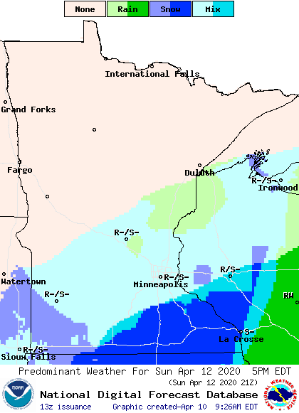
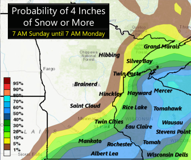
As the storm departs to the east on Monday, more of eastern and possibly northern Minnesota could see some light snow. Exact snow totals are still uncertain, but southeastern Minnesota is most likely to see heavier accumulations, with some places seeing 3 to 4 inches or more.
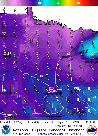
Even for parts of the state that remain dry, the storm will bring much colder air back in, and it will be windy, especially on Monday.
Once the cold air returns, all of next week likely stays below average across the entire state, with highs predominantly in the 30s and 40s. Here is how that temperature drop looks for the Twin Cities:

So, keep the shovels and warmer jackets handy!
Programming note
You can hear my live weather updates on Minnesota Public Radio at 7:48 a.m. Monday through Friday morning.

