
Heavy snow in some areas Sunday afternoon and evening; the latest snow reports
Low visibilities and gusty winds
Go Deeper.
Create an account or log in to save stories.
Like this?
Thanks for liking this story! We have added it to a list of your favorite stories.


A band of heavy snow has been slowly moving across the Twin Cities metro area and portions of southern Minnesota this Sunday afternoon:
Burnsville (in Dakota County) and Belle Plaine (Scott County) reported 5 inches of snow by mid-afternoon. Chanhassen (Hennepin County) tallied 3 inches so far. 6 inches was the latest total from Rochester Minnesota, and New Ulm reports 6.4 inches so far. The snow isn’t over yet.
The National Weather Service map of snowfall reports will show snow totals as they come in. Here’s how the map looked at mid-afternoon on Sunday:

You can click on any data point on the NWS site or hover over it for the exact total plus the time and location of the snow measurement.
Turn Up Your Support
MPR News helps you turn down the noise and build shared understanding. Turn up your support for this public resource and keep trusted journalism accessible to all.
Travel is very difficult in many areas around southern Minnesota and parts of western Wisconsin, with low visibilities and snow or slush on the roads.

The Minnesota Department of Transportation will have reports on road conditions. Wisconsin road conditions can be found here.
Here was the NWS snow forecast for Sunday/Sunday night that was posted earlier today:

Here’s how the snow forecast for southeastern Minnesota into western Wisconsin looked this morning:
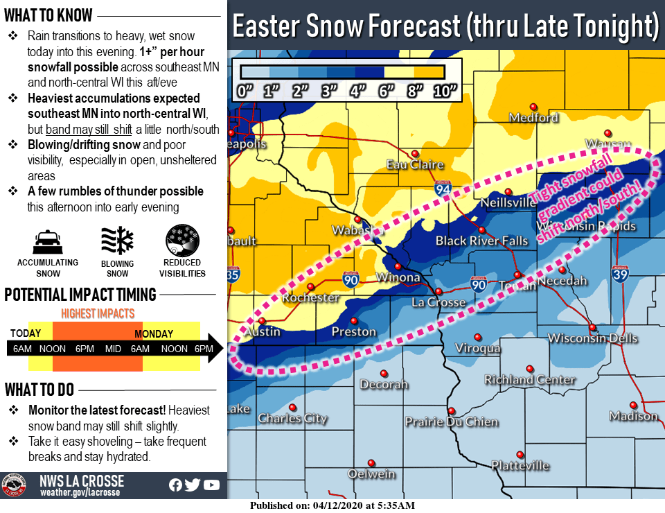
Some areas of heavy snow were also forecast for northwestern Wisconsin:

Warnings and advisories
Winter storm warnings (pink) are in effect Sunday into early Monday for much of southern Minnesota plus south and east portions of the metro area and portions of western Wisconsin:

Here’s an update on this storm from the NWS:
URGENT - WINTER WEATHER MESSAGE National Weather Service Twin Cities/Chanhassen MN 248 PM CDT Sun Apr 12 2020 ...Heaviest Snowfall Through 6 PM... ...Snowfall Tapering Off From West to East This Evening... .A Winter Storm Warning remains in effect for areas along and south of a line from Springfield through New Ulm to Cottage Grove in Minnesota, continuing to New Richmond and Rice Lake in Wisconsin. A Winter Weather Advisory is also in effect for a small swath of counties just to the north of that line, including the Twin Cities metro area. A persistent band of heavy snow, with rates of 1 to 2 inches per hour, will slowly move eastward this afternoon. The snowfall will begin to taper off this evening in Minnesota, but persist into west central Wisconsin through midnight, although not as heavy. By early this evening, those areas that had the persistent band of heavy snowfall will likely receive between 4 to 6 inches, with locally higher amounts. In the warned area, snowfall amounts in the 6 to 9 inch range will be common, with localized 10 to 12 inches possible once the snow ends. In addition, the heavy wet snow may cause some tree damage and power outages due to the combination of gusty winds and the heavy wet snow. MNZ063-070-078-130400- /O.CON.KMPX.WS.W.0004.000000T0000Z-200413T0900Z/ Washington-Dakota-Goodhue- Including the cities of Stillwater, Hastings, and Red Wing 248 PM CDT Sun Apr 12 2020 ...WINTER STORM WARNING REMAINS IN EFFECT UNTIL 4 AM CDT MONDAY... * WHAT...Heavy snow expected. Total snow accumulations of 5 to 8 inches. Winds gusting as high as 45 mph. * WHERE...Portions of east central, south central and southeast Minnesota. * WHEN...From 7 AM this morning to 4 AM CDT Monday. * IMPACTS...Travel could be very difficult. Patchy blowing snow could significantly reduce visibility. Due to the heavy, wet nature of the snow, tree damage and power outages could occur. PRECAUTIONARY/PREPAREDNESS ACTIONS... If you must travel, keep an extra flashlight, food, and water in your vehicle in case of an emergency. The latest road conditions for the state you are calling from can be obtained by calling 5 1 1.
Here are details aof the winter weather advisory that includes Hennepin, Ramsey, Carver and Anoka counties:
/O.EXT.KMPX.WW.Y.0014.000000T0000Z-200413T0600Z/ Hennepin-Anoka-Ramsey- Including the cities of Minneapolis, Blaine, and St Paul 248 PM CDT Sun Apr 12 2020 ...WINTER WEATHER ADVISORY NOW IN EFFECT UNTIL 1 AM CDT MONDAY... * WHAT...Snow expected. Total snow accumulations of 3 to 6 inches. Winds gusting as high as 35 mph. * WHERE...Portions of central, east central and southwest Minnesota. * WHEN...Until 1 AM CDT Monday. * IMPACTS...Travel could be difficult. Patchy blowing snow could significantly reduce visibility. Due to the heavy, wet nature of the snow, tree damage and power outages could occur. PRECAUTIONARY/PREPAREDNESS ACTIONS... Slow down and use caution while traveling. The latest road conditions for the state you are calling from can be obtained by calling 5 1 1.
You can hear updated weather information on the MPR network, and you’ll see updated weather info on the MPR News live weather blog.
It’s probably good to remember that April snow tends to melt within a few days.
The week ahead
Snow may linger into Monday morning in parts of western Wisconsin and far northeastern Minnesota. The Twin Cities metro area could see a passing rain shower or snow shower on Monday. Twin Cities metro area highs are projected to be around 40 Monday and Tuesday, followed by lower 40s Wednesday, upper 40s Thursday and lower 50s on Friday. We may be close to 60 next Saturday.
Programming note
You can hear my live weather updates on MPR News at 7:35 a.m., 9:35 a.m. and 4:35 p.m. each Saturday and Sunday.You can hear my live weather updates on MPR News at 7:35 a.m., 9:35 a.m. and 4:35 p.m. each Saturday and Sunday.

