
Mild Sunday temps; some spots may see an afternoon shower
The Mississippi River was much higher one year ago
Go Deeper.
Create an account or log in to save stories.
Like this?
Thanks for liking this story! We have added it to a list of your favorite stories.


Our Saturday afternoon high temp at Minneapolis-St. Paul International Airport was 71 degrees. That’s 8 degrees warmer than our average Twin Cities high temp this time of year. I’m sure that many metro-area residents enjoyed the mild temps and the morning sunshine that was followed by decorative afternoon clouds.
Rain chances
Radar showed a few very scattered showers in the eastern part of the Twin Cities metro area Saturday afternoon, but most of the metro area had a dry day. Much of western Minnesota and parts of south-central Minnesota saw numerous areas of showers and a few embedded thunderstorms on Saturday. Scattered showers were also noted on radar Saturday afternoon in parts of west-central Wisconsin and southeastern Minnesota. Saturday evening shower/t-storm chances are expected to be highest in western Minnesota, with scattered showers and an isolated t-storm possible in the other areas that saw some Saturday afternoon showers. A few spots in the metro area may see a passing Saturday evening shower, but it’s likely to be a dry Saturday evening in most of the metro.
On Sunday, eastern Minnesota and parts of western Wisconsin may see scattered afternoon showers, with an isolated thunderstorm also possible. The National Oceanic and Atmospheric Administration’s North American Mesoscale (NAM) forecast model shows the potential precipitation pattern Sunday and Sunday evening:
Turn Up Your Support
MPR News helps you turn down the noise and build shared understanding. Turn up your support for this public resource and keep trusted journalism accessible to all.
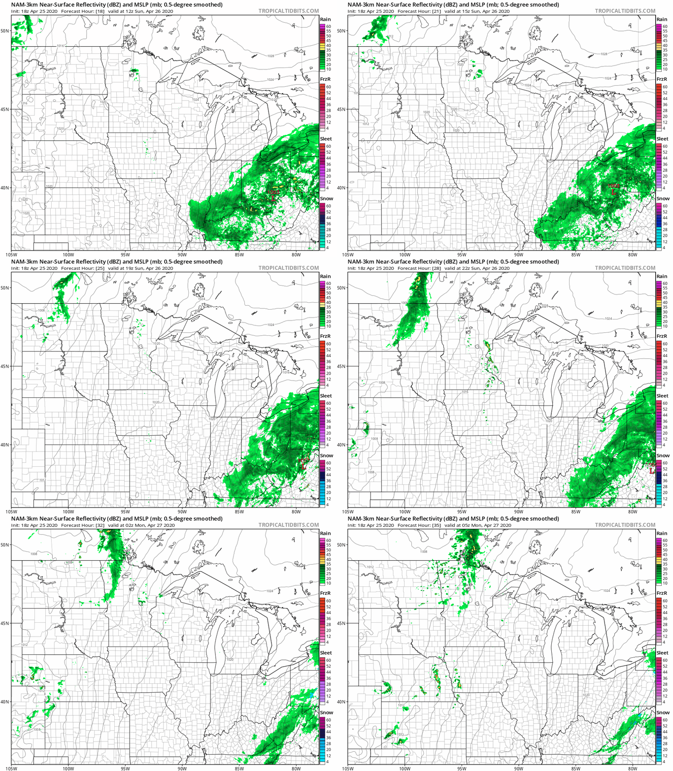
Some rain also moves into northwestern Minnesota Sunday evening.
You can hear updated weather information on the MPR network, and you’ll see updated weather info on the MPR News live weather blog.
Temperature trends
Sunday highs will be in the 60s across most of Minnesota:
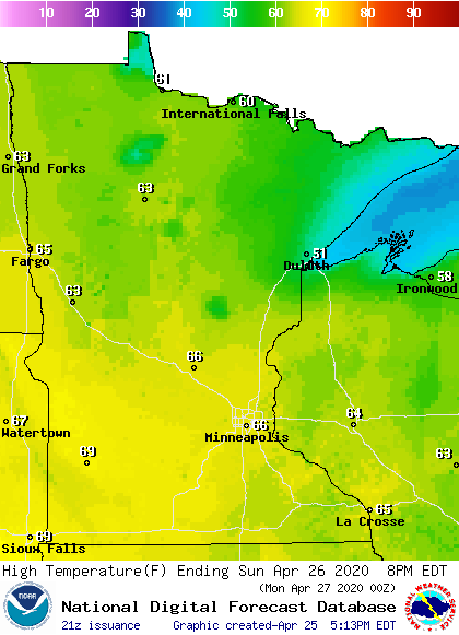
Northeastern Minnesota will see some 50s.
Monday will be the warmest day of the coming week, with highs in the 70s in much of central and southern Minnesota:
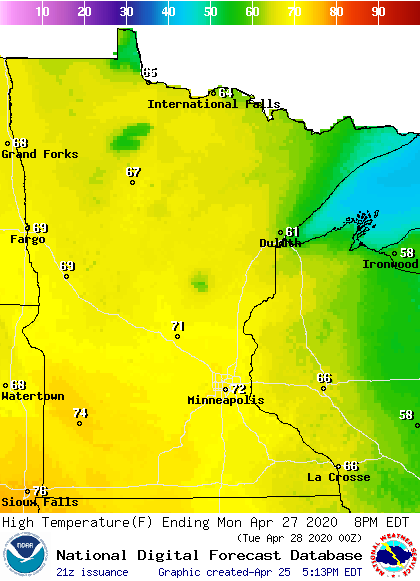
Twin Cities metro area highs are projected to reach the lower 70s Monday, followed by mid 60s Tuesday and Wednesday and upper 60s on Thursday and Friday.
What a difference one year makes
You can click on any location on the NWS Advanced Hydrologic Prediction Service (AHPS) site to get hydrographs of recent and forecast river levels. Some locations list levels in feet above sea level, others list levels in feet above a local reference point.
Here’s the Saturday afternoon hydrograph for the Mississippi River at St. Paul:

The Mississippi River remains well below flood stage at St. Paul, with a listed level of 7. 6 feet.
One year ago today, the Mississippi River at St. Paul was at major flood stage, at 17.5 feet. That’s almost 10 feet higher than it was today!
Much of Harriet Island Regional Park in St. Paul was underwater one year ago::

All of Harriet Island Regional Park was dry on the St. Paul webcam today:

The 2019 hydrograph for the Mississippi River at St. Paul can be viewed in my 2019 Updraft post here.
Programming note
You can hear my live weather updates on MPR News at 7:35 a.m., 9:35 a.m. and 4:35 p.m. each Saturday and Sunday.

