
Breezy, warm and dry today; outdoor burning is not recommended
Red flag warnings Saturday afternoon for much of Minnesota
Go Deeper.
Create an account or log in to save stories.
Like this?
Thanks for liking this story! We have added it to a list of your favorite stories.


Our average high temp is 65 degrees this time of year in the Twin Cities. Many spots in the Twin Cities metro area are expected to top out in the mid 70s Saturday afternoon, and a few spots could hit the upper 70s.
Saturday highs reach the 70s across most of central and southern Minnesota plus western Wisconsin, with some 60s in far northern Minnesota. Afternoon wind gusts of 20 to 30 mph are expected across much of Minnesota and parts of western Wisconsin.
Red Flag Warning this afternoon
Any wildfires that develop this afternoon and early this evening will likely spread rapidly. Outdoor burning is not recommended today.
Turn Up Your Support
MPR News helps you turn down the noise and build shared understanding. Turn up your support for this public resource and keep trusted journalism accessible to all.
Red Flag warnings cover much of Minnesota from noon to 7 p.m. this Saturday:

Here’s a closer look at the central and southern Minnesota portions of the warning:

Details of the warning:
URGENT - FIRE WEATHER MESSAGE National Weather Service Twin Cities/Chanhassen MN 404 AM CDT Sat May 2 2020 ...Critical Fire Weather Conditions Expected This Afternoon... .Dry and breezy conditions are expected today. Sustained northwest winds of 20 to 25 mph with gusts near 30 mph are likely. Humidity levels will range from 15 to 25 percent by the afternoon. The Red Flag Warning covers most of central Minnesota. MNZ054-060-061-064>069-073>076-082-083-021715- /O.NEW.KMPX.FW.W.0002.200502T1700Z-200503T0000Z/ Lac Qui Parle-Hennepin-Anoka-Yellow Medicine-Renville-McLeod- Sibley-Carver-Scott-Redwood-Brown-Nicollet-Le Sueur-Watonwan- Blue Earth- 404 AM CDT Sat May 2 2020 ...RED FLAG WARNING IN EFFECT FROM NOON TODAY TO 7 PM CDT THIS EVENING FOR VERY LOW HUMIDITY AND BREEZY WINDS FOR MOST OF CENTRAL MINNESOTA... The National Weather Service in Twin Cities/Chanhassen has issued a Red Flag Warning, which is in effect from noon today to 7 PM CDT this evening. * AFFECTED AREA...Much of and south central and east central Minnesota. * WIND...Northwest sustained 20 to 25 mph, with gusts near 30 mph. * HUMIDITY...As low as 15 to 25 percent. * IMPACTS...Any fires that develop will likely spread rapidly. Outdoor burning is not recommended. PRECAUTIONARY/PREPAREDNESS ACTIONS... A Red Flag Warning means that critical fire weather conditions are either occurring now....or will shortly. A combination of strong winds...low relative humidity...and warm temperatures can contribute to extreme fire behavior.
You can hear updated weather information on the MPR network, and you’ll see updated weather info on the MPR News live weather blog.
Any chance of rain?
Most of Minnesota and western Wisconsin will have a dry Saturday. A stray shower may clip far southern Minnesota Saturday afternoon.
The National Oceanic and Atmospheric Administration’s North American Mesoscale (NAM) forecast model shows the potential rain pattern Saturday and Saturday evening:
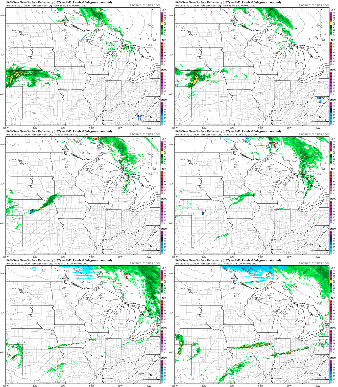
Sunday looks dry.
The best chance of rain in the Twin Cities won’t arrive until Monday afternoon and Monday evening, with the rain expected to linger into Tuesday morning.
Temperature trends
Sunday highs are expected to range from 50s in northern Minnesota to around 70 in the far southeast:
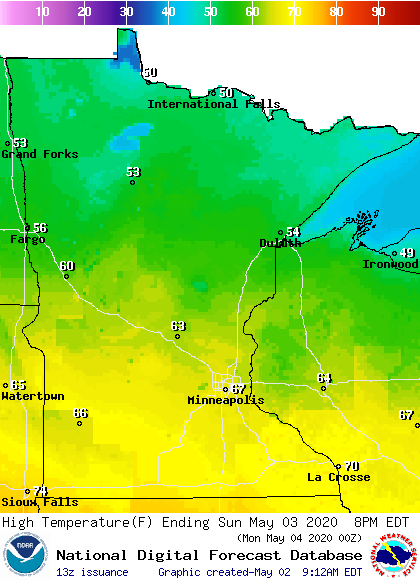
Some spots in the Twin Cities metro area could touch 70.
Twin Cities metro area highs are projected to reach about 60 degrees on Monday, followed by lower 60s Tuesday and Wednesday, then mid 60s Thursday and upper 50s on Friday.
Programming note
You can hear my live weather updates on MPR News at 7:35 a.m., 9:35 a.m. and 4:35 p.m. each Saturday and Sunday.

