
Weekend forecast: Saturday freeze warning; Sunday morning snowflakes possible
Freeze warning includes Twin Cities
Go Deeper.
Create an account or log in to save stories.
Like this?
Thanks for liking this story! We have added it to a list of your favorite stories.


The 2020 Minnesota Fishing Opener is this Saturday. Dress for chilly weather, and parts of Minnesota will see some snow showers or rain showers. More on that in a moment.
Winds will start out light, then increase to 8-16 mph in many areas Saturday afternoon. The Minnesota Department of Natural Resources has information about social distancing while enjoying the outdoors.
Fishing opener weather history
The Minnesota State Climatology Office has a summary of historic Minnesota Fishing Opener Weather. As you might imagine, we’ve seen a wide range of weather on the fishing opener:
Minnesota's Fishing Opener weather can be variable in every sense of the word. We have seen hot, cold, wet, dry, stormy and even snowy. With such a large state and so many lakes, we have had years that were seemingly perfect in one area, only to be blustery and miserable in another.
The most common Fishing Opener conditions include partly cloudy to cloudy skies, perhaps mist or sprinkles early, morning temperatures around 40 in the north to near 50 in the south, with afternoon temperatures climbing into the 60s to near 70, and a light breeze that increase slightly through the day. Temperatures on and near Lake Superior are often held to the 50s. Three out of four years are free of measurable precipitation. Northern Minnesota has had snowflakes during the Opener at least five times in 68 years.
Opening day temperatures have started as low as 24 degrees at International Falls (1996,2004), and sub-freezing conditions have even affected Minneapolis (31 degrees in 1979). On the warm side, St. Cloud saw 92 degrees in 1987, Minneapolis reported 91 in 1987, and International Falls reached 88 in 1977.
Precipitation is not uncommon, but certainly is not the rule either. Three-quarters of past opening days have been free of measurable precipitation, and two-thirds of the fishing openers have been free of any precipitation, measurable or not. On those days with measurable rain, the amounts averaged close to a half-inch in the south and a quarter inch in the north. Rainfall has exceeded one inch once in St. Cloud, and twice in the Twin Cities, with a maximum of 1.64" in 1965. Snow, usually just a trace, was officially recorded in 1963, 1993, 2000, 2009 and 2013 at International Falls, and in 1968 at St. Cloud.
Friday night/Saturday freeze warning
Temperatures will plunge overnight. You’ll want to bring your potted plants indoors and cover tender plants that cannot be brought indoors.
Turn Up Your Support
MPR News helps you turn down the noise and build shared understanding. Turn up your support for this public resource and keep trusted journalism accessible to all.
Lows temperatures will dip into the 20s and 30s across much of Minnesota and western Wisconsin late Friday night and early Saturday morning:
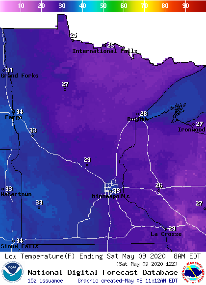
Here’s a closer look at low temps Saturday morning:
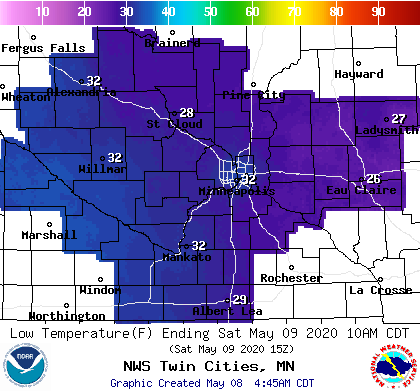
Official temperatures are measured 5 feet above the ground. When winds are light, the temperature at ground level can be several degrees cooler than the temp measured at 5 feet above the ground.
I expect ground-level temps to dip into the 20s in many parts of the metro area and elsewhere in Minnesota and western Wisconsin.
Freeze warnings run from 1 a.m. to 8 a.m. Saturday across much of southern Minnesota and parts of central Minnesota and western Wisconsin:

The freeze warning begins at midnight Friday night in southeastern Minnesota.
Freezing temps are also expected in northern Minnesota and northwestern Wisconsin, but the main growing season isn’t considered to have started in those areas.
Updates on freeze warnings can be found on the NWS Twin Cities site.
Weekend highs
Our average Twin Cities high temperature is 68 degrees on May 9 and May 10. We’ll be well below average this weekend.
Saturday highs will be mainly in the 50s, with some 40s in northwestern Minnesota and parts of the northeast:
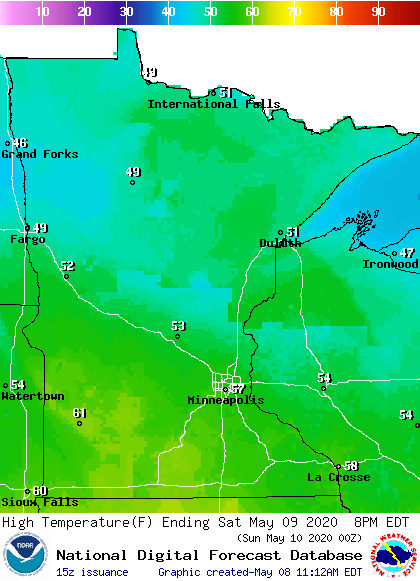
A few spots in southwestern Minnesota may top 60 degrees.
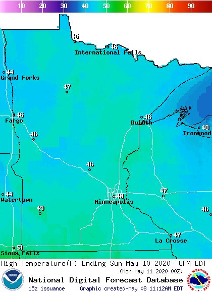
Sunday highs will be in the 40s:
Rain and snow chances
A low-pressure system is expected to spread precipitation across parts of Minnesota and Wisconsin Saturday into Sunday morning. It’ll bring rain to some areas and a mix of rain and snow to other areas.
There could be a swath of accumulating snow from northwestern Minnesota through central Minnesota and on into western Wisconsin.
The National Oceanic and Atmospheric Administration’s North American Mesoscale (NAM) forecast model shows the potential precipitation pattern Saturday morning through Sunday morning:
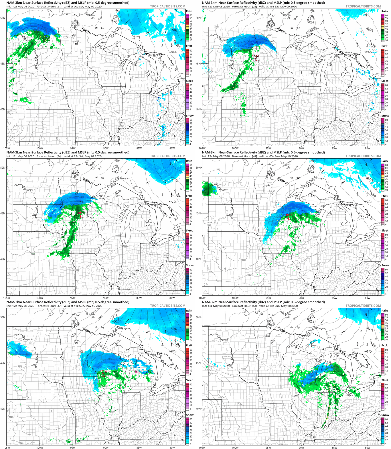
With this track, the Twin Cities metro area would have a chance of rain showers Saturday afternoon and evening, with a mix of rain and snow possible overnight Saturday night into Sunday morning.
The northern part of the Twin Cities metro area seems to have a chance of some snow accumulation on grassy areas. There may be a swath of 2-plus inches of snow in some portions of Minnesota that are north of Interstate-94. Check for updates.
You can hear updated weather information on the MPR network, and you’ll see updated weather info on the MPR News live weather blog.
Mother’s Day snow record
Measurable snow is one-tenth of an inch or more of snow. The NWS checked Twin Cities official weather records and found that our most recent Mother’s Day with measurable snow was in 1946:
We’ll see if we end our snow-less Mother’s Day streak this year.

