
Cool and breezy today; freeze warning late tonight
A passing shower/flurry in some areas
Go Deeper.
Create an account or log in to save stories.
Like this?
Thanks for liking this story! We have added it to a list of your favorite stories.


I wish that I could be talking about sunshine and 70s, but that’s not in the cards this Mother’s Day.
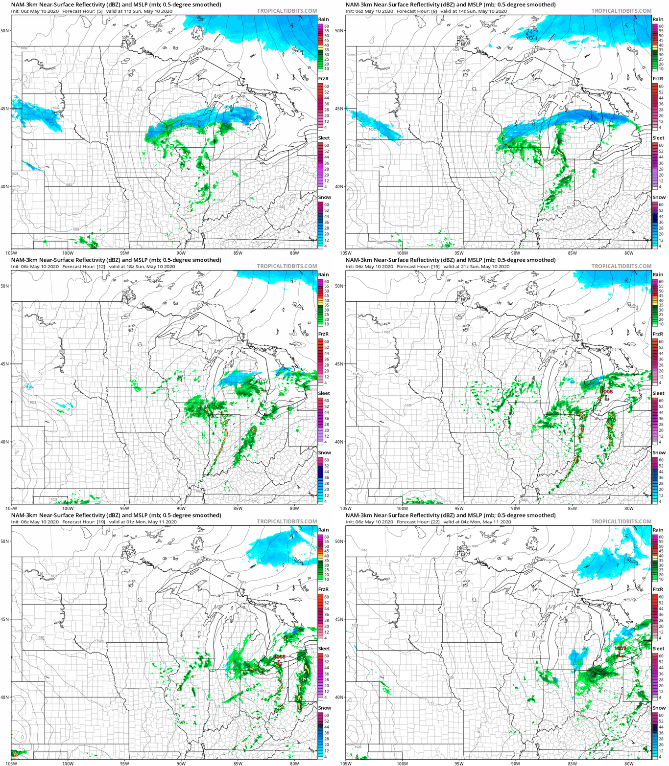
Southeastern Minnesota and parts of western Wisconsin have some lingering rain showers and snow showers this Sunday morning. Elsewhere in central and southern Minnesota, there may be a passing sprinkle or flurry today.
The National Oceanic and Atmospheric Administration’s North American Mesoscale (NAM) forecast model shows the potential precipitation pattern Sunday morning through Sunday evening:
You can hear updated weather information on the MPR network, and you’ll see updated weather info on the MPR News live weather blog.
Turn Up Your Support
MPR News helps you turn down the noise and build shared understanding. Turn up your support for this public resource and keep trusted journalism accessible to all.
Temperatures and winds
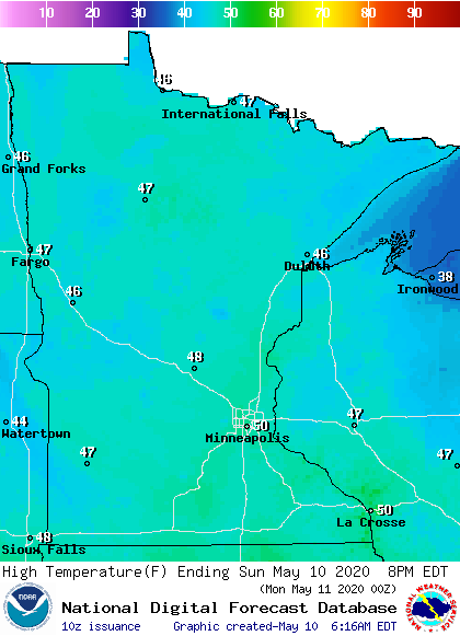
Sunday highs will be in the 40s across most of Minnesota and western Wisconsin, but the Twin Cities metro area and points to the southeast may touch 50:
It’ll be a breezy day, with winds gusting to 20-30 mph at times:
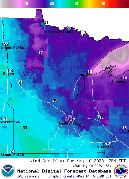
Plotted gusts are in knots, with 17 knots equal to about 20 mph.
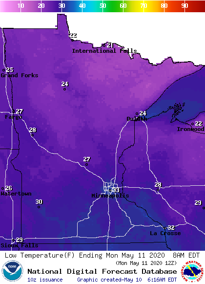
Winds will lighten up overnight, and lows in the 20s to lower 30s will be common early Monday:
Freeze warnings run from 2 a.m. to 8 a.m. Monday across much of southern Minnesota and parts of central Minnesota and western Wisconsin:

Freezing temps are also expected in northern Minnesota and northwestern Wisconsin, but the main growing season isn’t considered to have started in those areas.
Here are details of the freeze warning, which includes the Twin Cities metro area:
URGENT - WEATHER MESSAGE National Weather Service Twin Cities/Chanhassen MN 241 AM CDT Sun May 10 2020 MNZ056>070-073>078-082>085-091>093-WIZ023>028-101545- /O.NEW.KMPX.FZ.W.0003.200511T0700Z-200511T1300Z/ Chippewa-Kandiyohi-Meeker-Wright-Hennepin-Anoka-Ramsey-Washington- Yellow Medicine-Renville-McLeod-Sibley-Carver-Scott-Dakota- Redwood-Brown-Nicollet-Le Sueur-Rice-Goodhue-Watonwan-Blue Earth- Waseca-Steele-Martin-Faribault-Freeborn-St. Croix-Pierce-Dunn- Pepin-Eau Claire- Including the cities of Montevideo, Willmar, Litchfield, Monticello, Minneapolis, Blaine, St Paul, Stillwater, Granite Falls, Olivia, Hutchinson, Gaylord, Chanhassen, Chaska, Victoria, Shakopee, Hastings, Redwood Falls, New Ulm, St Peter, Le Sueur, Faribault, Red Wing, St James, Mankato, Waseca, Owatonna, Fairmont, Blue Earth, Albert Lea, Hudson, River Falls, Menomonie, Durand, Chippewa Falls, and Eau Claire 241 AM CDT Sun May 10 2020 ...FREEZE WARNING IN EFFECT FROM 2 AM TO 8 AM CDT MONDAY... * WHAT...Sub-freezing temperatures in the upper 20s to lower 30s expected. * WHERE...Portions of west central Wisconsin and central, east central, south central, southeast, southwest and west central Minnesota. * WHEN...From 2 AM to 8 AM CDT Monday. * IMPACTS...Frost and freeze conditions will kill crops, other sensitive vegetation and possibly damage unprotected outdoor plumbing and hoses. * ADDITIONAL DETAILS...There`s a good chance that sub-freezing temperatures will return again Monday night into Tuesday morning, but then temperatures will warm the rest of the week. PRECAUTIONARY/PREPAREDNESS ACTIONS... Take steps now to protect tender plants from the cold. Cover or drain above-ground pipes and hoses to protect them from freezing.
Updraft will be updated by around 9:45 a.m., with a look at Sunday and the week ahead.
Programming note
You can hear my live weather updates on MPR News at 7:35 a.m., 9:35 a.m. and 4:35 p.m. each Saturday and Sunday.

