
Soaking rains Saturday night into Sunday; warmer temps this coming week
Some areas may see 2 to 3 inches of rain by Sunday evening
Go Deeper.
Create an account or log in to save stories.
Like this?
Thanks for liking this story! We have added it to a list of your favorite stories.


Northwestern sections of the Twin Cities metro area saw some rain Saturday afternoon, while people in the southeastern part of the metro had dry weather.
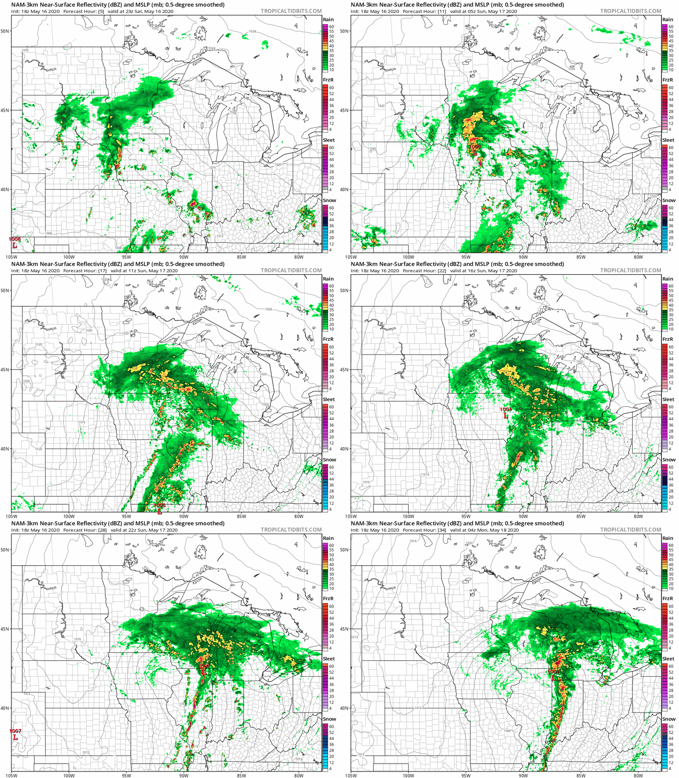
The rain will expand to the east and northeast Saturday evening and overnight Saturday night. Much of central and southern Minnesota, western Wisconsin and parts of northeastern Minnesota will have rain Saturday night into Sunday. There could even be some rumbles of thunder. Some forecast models show that the rain won’t taper off until late Sunday afternoon or Sunday evening in the Twin Cities metro area, southeastern Minnesota and western Wisconsin.
The National Oceanic and Atmospheric Administration’s North American Mesoscale (NAM) forecast model shows the potential rain pattern Saturday evening through Sunday evening:
You can hear updated weather information on the MPR network, and you’ll see updated weather info on the MPR News live weather blog.
Turn Up Your Support
MPR News helps you turn down the noise and build shared understanding. Turn up your support for this public resource and keep trusted journalism accessible to all.
How much rain?
Weekend rain totals are expected to be highest in portions of southern Minnesota, the far southern part of the Twin Cities metro area and parts of western Wisconsin. Here’s the NWS weekend rainfall forecast, with “today” referring to Saturday:
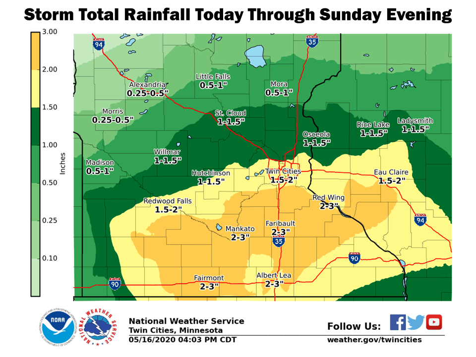
The central part of the Twin Cities metro area may end up with weekend rain totals in the 1.5 to 2 inch range, with some totals of 2 to 3 inches in parts of the south metro.
Localized amounts higher than those shown on the graphic would occur in some of the areas that see a thunderstorm.
Sunday temps and winds
Our average Twin Cities high temp is 70 degrees on May 17. We’re expected to top out in the upper 50s this Sunday. Highs in the 50s are forecast Sunday afternoon across much of eastern Minnesota and western Wisconsin:
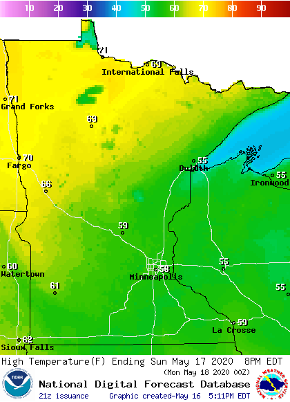
Northwestern Minnesota will have plenty of sunshine on Sunday and some spots up there will top 70.
Sunday will be windy, with gusts of 25 to 30 mph at times in the metro area, southern and eastern Minnesota and western Wisconsin:
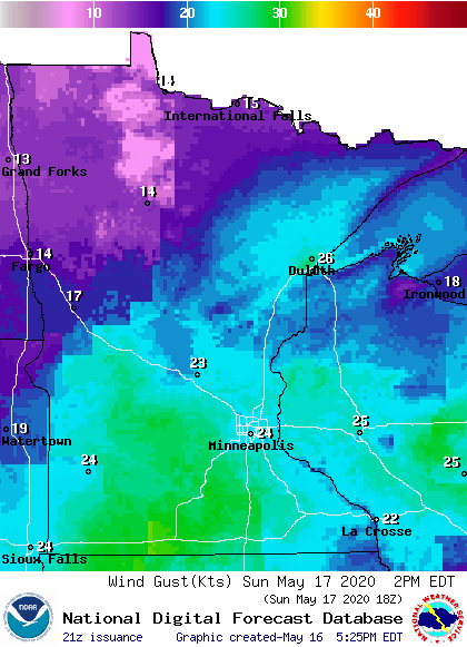
Plotted gusts are in knots, with 24 knots equal to about 28 mph.
Much warmer weather this coming week
If you prefer summery weather, hang in there. Twin Cities metro area highs are projected to reach the lower 70s on Monday, followed by mid 70s Tuesday, around 80 on Wednesday and lower 80s Thursday and Friday.
Programming note
You can hear my live weather updates on MPR News at 7:35 a.m., 9:35 a.m. and 4:35 p.m. each Saturday and Sunday.

