
Highs in the 70s return on Sunday; warmer temps this coming week
Parts of northern Minnesota could see frost overnight and early Sunday
Go Deeper.
Create an account or log in to save stories.
Like this?
Thanks for liking this story! We have added it to a list of your favorite stories.


The final morning of May could deliver some frost to parts of northern Minnesota and northwestern Wisconsin. There’s a frost advisory late Saturday night and early Sunday in the blue-shaded areas:

Details of the frost advisory:
National Weather Service Duluth MN 434 PM CDT Sat May 30 2020 MNZ018-019-026-035-037-WIZ001>004-008-009-311300- /O.NEW.KDLH.FR.Y.0002.200531T0700Z-200531T1300Z/ North Itasca-Central St. Louis-South Itasca-Northern Aitkin- Carlton and South St. Louis-Douglas-Bayfield-Ashland-Iron-Sawyer- Price- Including the cities of Bigfork, Hibbing, Grand Rapids, Hill City, Duluth, Superior, Washburn, Bayfield, Ashland, Hurley, Hayward, and Phillips 434 PM CDT Sat May 30 2020 ...FROST ADVISORY IN EFFECT FROM 2 AM TO 8 AM CDT SUNDAY... * WHAT...Temperatures as low as 36 and light winds will create conditions favorable for areas of frost. * WHERE...Portions of north central and northwest Wisconsin and east central, north central and northeast Minnesota. * WHEN...From 2 AM to 8 AM CDT Sunday. * IMPACTS...Frost could kill sensitive outdoor vegetation if left uncovered. PRECAUTIONARY/PREPAREDNESS ACTIONS... Take steps now to protect tender plants from frost damage.
Twin Cities metro area lows are expected to be in the 40s early Sunday morning.
Turn Up Your Support
MPR News helps you turn down the noise and build shared understanding. Turn up your support for this public resource and keep trusted journalism accessible to all.
Temperature trends
Our average Twin Cities high temperature is 74 degrees this time of year. Metro area highs are expected to reach the mid 70s on Sunday, and we’ll share 70s with most of Minnesota and western Wisconsin:

Some spots along the North Shore of Lake Superior may top out in the upper 60s.
Summery highs return this week. Twin Cities metro area highs are projected to reach the lower 80s on Monday, followed by upper 80s Tuesday and Wednesday and mid 80s Thursday and Friday.
Warmth may continue next weekend into the start of the following week. The NWS Climate Prediction Center shows a tendency for above-normal temps in Minnesota and Wisconsin from June 5 through June 9:

We’ll see if that pans out.
Rain chances?
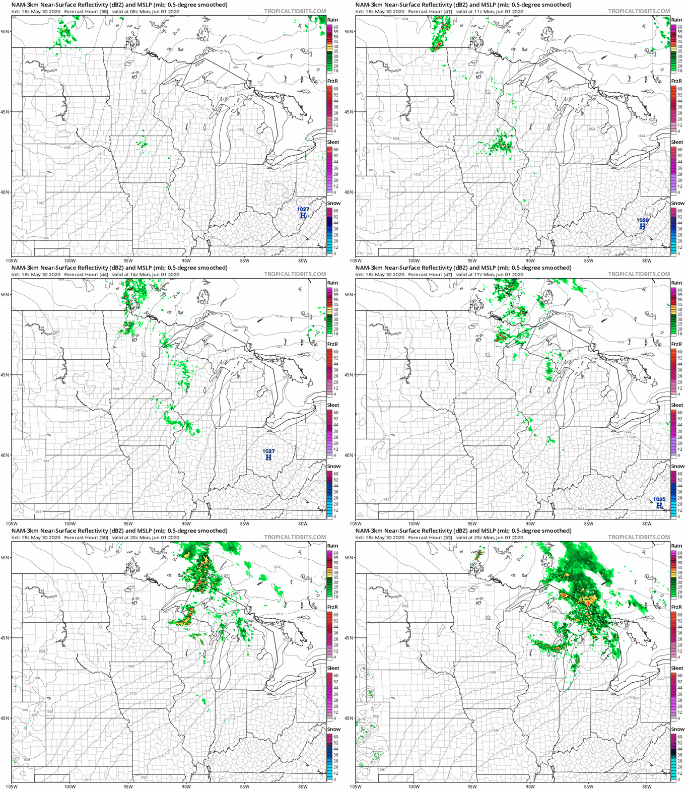
Southwestern Minnesota may see a passing shower Sunday morning. The next chance of rain for most areas will hold off until late Sunday night into Monday morning.
The National Oceanic and Atmospheric Administration’s North American Mesoscale (NAM) forecast model shows this potential rain pattern on Monday:
You can hear updated weather information on the MPR network, and you’ll see updated weather info on the MPR News live weather blog.
Programming note
You can hear my live weather updates on MPR News at 7:35 a.m., 9:35 a.m. and 4:35 p.m. each Saturday and Sunday.

