
Temps and humidity on the rise; NW Minnesota may see some severe storms
Windy today and tomorrow
Go Deeper.
Create an account or log in to save stories.
Like this?
Thanks for liking this story! We have added it to a list of your favorite stories.



Our average Twin Cities high temperature is 76 degrees this time of year. We’re shooting for highs in the upper 80s in the metro area this Sunday afternoon.
Sunday highs will probably reach the 90s in southwestern and west-central Minnesota, with a lot of 80s elsewhere. There’ll be some 70s in north-central Minnesota and 60s in northeastern Minnesota.
Dew points in the 60s will spread across western Minnesota and much of central and southern Minnesota, so it’ll feel summery. Wind gusts of 25-35 mph are expected.
Severe weather outlook
Turn Up Your Support
MPR News helps you turn down the noise and build shared understanding. Turn up your support for this public resource and keep trusted journalism accessible to all.
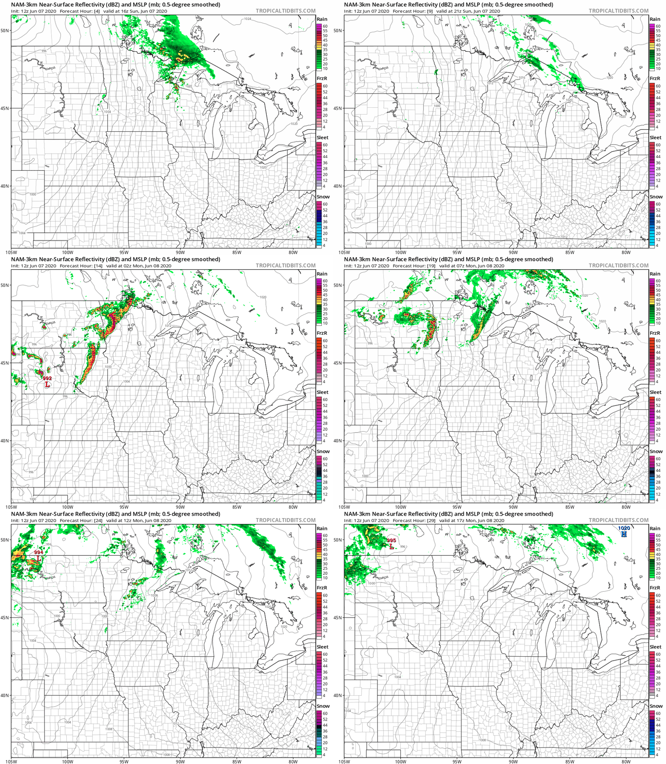
Showers and thunderstorms linger in parts of far northeastern Minnesota into early Sunday afternoon, then our attention will focus on northwestern Minnesota. Forecast models show another round of t-storms moving into northwestern Minnesota and portions of west-central Minnesota late Sunday afternoon and Sunday evening and spreading eastward.
Here’s the National Oceanic and Atmospheric Administration’s North American Mesoscale (NAM) forecast model for Sunday afternoon through Sunday night and early Monday:
The NWS Storm Prediction Center shows an enhanced risk of severe weather in northwestern Minnesota and part of west-central Minnesota this Sunday afternoon and Sunday night:

Enhanced risk means that numerous severe thunderstorms are possible:

The severe risk ramps up after about 4 p.m. in northwestern Minnesota. Here are some details from the Grand Forks office of the NWS:

You can hear updated weather information on the MPR network, and you’ll see updated weather info on the MPR News live weather blog.
Summery weather lingers on Monday
Monday highs reach the 90s across the southern half of Minnesota plus western Wisconsin:
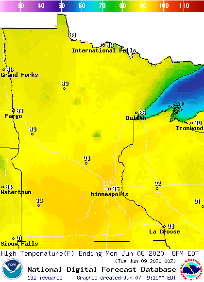
It’ll be steamy, with dew points in the 60s in many areas:

Winds remain strong on Monday, gusting over 25 mph in central and southern Minnesota:
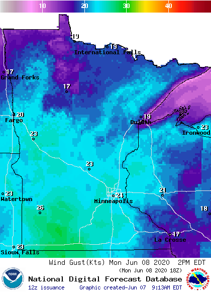
Plotted values are in knots, with 24 knots equal to 28 mph.
Cooler temps the rest of this week
Twin Cities metro area highs are projected to hit around 80 degrees on Tuesday, followed by lower 70s Wednesday, Thursday and Friday.
Tropical Storm Cristobal
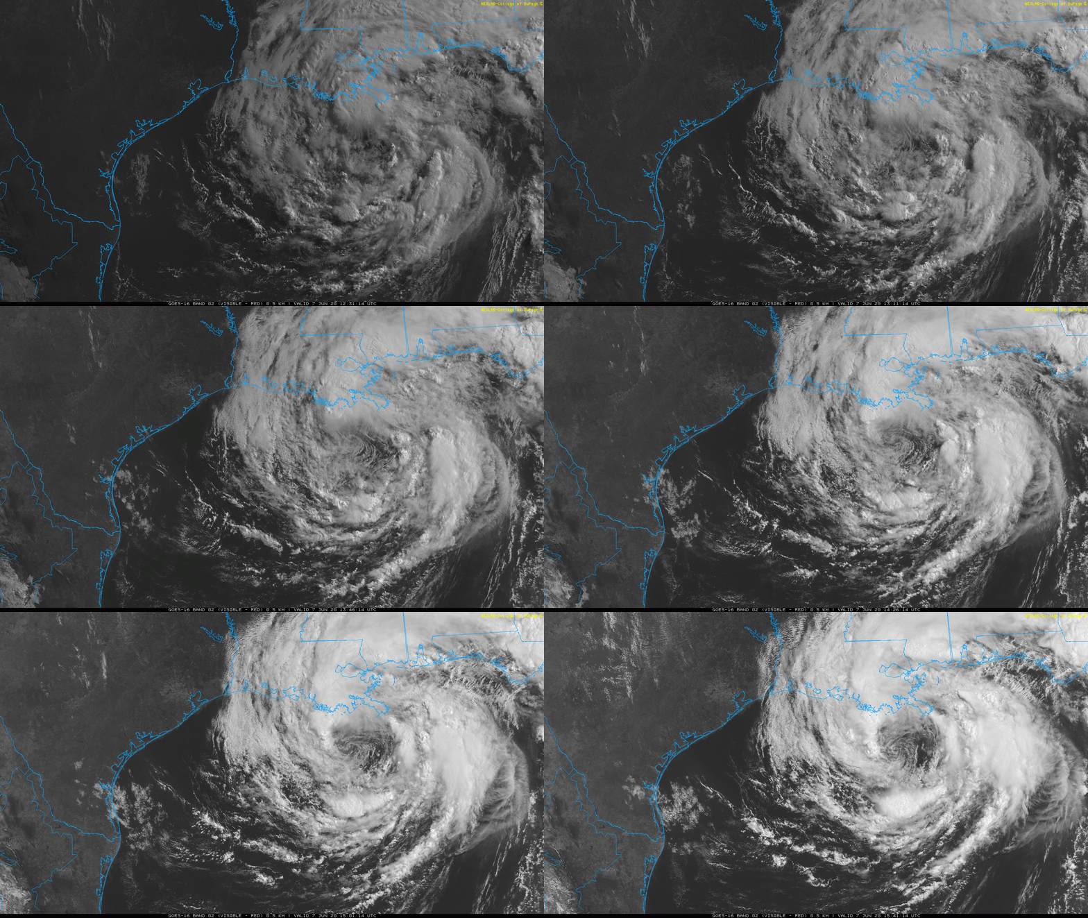
According to NOAA’s National Hurricane Center, the center of Tropical Storm Cristobal was about 90 miles south of New Orleans Sunday morning and Cristobal was moving northward at 12 mph. Cristobal had max sustained winds of 50 mph Sunday morning. Here’s the cone of uncertainty for Cristobal’s track over the next few days:
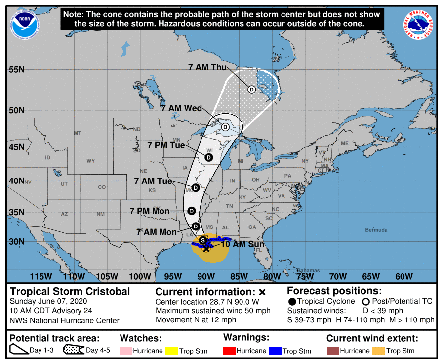
According to the National Hurricane Center:
the center of Cristobal will approach the northern Gulf of Mexico coast this afternoon, then move inland across Louisiana late today through Monday morning, and northward across Arkansas and Missouri Monday afternoon into Tuesday.
Here’s the Sunday morning briefing from the NHC:
Tropical Storm Cristobal Advisory Number 24 NWS National Hurricane Center Miami FL AL032020 1000 AM CDT Sun Jun 07 2020 ...CRISTOBAL MOVING CLOSER TO SOUTHEASTERN LOUISIANA... ...HEAVY RAINFALL AND STORM SURGE EXPECTED FROM SOUTHEASTERN LOUISIANA EASTWARD TO THE FLORIDA PANHANDLE... SUMMARY OF 1000 AM CDT...1500 UTC...INFORMATION ----------------------------------------------- LOCATION...28.7N 90.0W ABOUT 90 MI...145 KM S OF NEW ORLEANS LOUISIANA MAXIMUM SUSTAINED WINDS...50 MPH...85 KM/H PRESENT MOVEMENT...N OR 355 DEGREES AT 12 MPH...19 KM/H MINIMUM CENTRAL PRESSURE...994 MB...29.36 INCHES WATCHES AND WARNINGS -------------------- CHANGES WITH THIS ADVISORY: None. SUMMARY OF WATCHES AND WARNINGS IN EFFECT: A Storm Surge Warning is in effect for... * Mouth of the Mississippi River to Ocean Springs Mississippi * Lake Borgne A Storm Surge Watch is in effect for... * East of Morgan City Louisiana to the mouth of the Mississippi River A Tropical Storm Warning is in effect for... * Intracoastal City Louisiana to the Okaloosa/Walton County Florida line * Lake Pontchartrain and Lake Maurepas A Storm Surge Warning means there is a danger of life-threatening inundation, from rising water moving inland from the coastline, during the next 36 hours in the indicated locations. For a depiction of areas at risk, please see the National Weather Service Storm Surge Watch/Warning Graphic, available at hurricanes.gov. This is a life-threatening situation. Persons located within these areas should take all necessary actions to protect life and property from rising water and the potential for other dangerous conditions. Promptly follow evacuation and other instructions from local officials. A Storm Surge Watch means there is a possibility of life- threatening inundation, from rising water moving inland from the coastline, in the indicated locations during the next 48 hours. A Tropical Storm Warning means that tropical storm conditions are expected somewhere within the warning area within the next 24 hours. For storm information specific to your area, including possible inland watches and warnings, please monitor products issued by your local National Weather Service forecast office. DISCUSSION AND OUTLOOK ---------------------- At 1000 AM CDT (1500 UTC), the center of Tropical Storm Cristobal was located near latitude 28.7 North, longitude 90.0 West. Cristobal is moving toward the north near 12 mph (19 km/h), and this general motion is expected to continue today, followed by a gradual turn toward the north-northwest late today or tonight. On the forecast track, the center of Cristobal will approach the northern Gulf of Mexico coast this afternoon, then move inland across Louisiana late today through Monday morning, and northward across Arkansas and Missouri Monday afternoon into Tuesday. Data from an Air Force Reserve reconnaissance aircraft and NOAA Doppler weather radars indicate that maximum sustained winds remain near 50 mph (85 km/h) with higher gusts. Little change in strength is forecast before landfall. Gradual weakening will begin once Cristobal moves inland. Tropical-storm-force winds extend outward up to 205 miles (335 km), mainly to the east of the center. A Weatherflow site at Bayou Bienvenue, Louisiana, recently measured a sustained wind of 37 mph (60 km/h) and a gust to 47 mph (76 km/h). The estimated minimum central pressure is 994 mb (29.36 inches). HAZARDS AFFECTING LAND ---------------------- Key messages for Cristobal can be found in the Tropical Cyclone Discussion under AWIPS header MIATCDAT3, WMO header WTNT43 KNHC, and on the web at www.hurricanes.gov/text/MIATCDAT3.shtml STORM SURGE: The combination of a dangerous storm surge and the tide will cause normally dry areas near the coast to be flooded by rising waters moving inland from the shoreline. The water could reach the following heights above ground somewhere in the indicated areas if the peak surge occurs at the time of high tide... Mouth of the Mississippi River to Ocean Springs MS including Lake Borgne...3-5 ft Morgan City LA to Mouth of the Mississippi River...2-4 ft Ocean Springs MS to Marco Island FL including Mobile Bay, Pensacola Bay, and Tampa Bay...1-3 ft The deepest water will occur along the immediate coast in areas of onshore winds and will likely extend along the coast well to the east of the center. Surge-related flooding depends on the relative timing of the surge and the tidal cycle, and can vary greatly over short distances. For information specific to your area, please see products issued by your local National Weather Service forecast office. WIND: Tropical storm conditions are expected within the Tropical Storm Warning area along the northern Gulf coast through tonight. RAINFALL: Cristobal is expected to produce total rainfall accumulations of 4 to 8 inches across portions of the central Gulf Coast into the Lower Mississippi Valley, with isolated amounts to 12 inches. Rainfall totals of 2 to 4 inches with local amounts to 6 inches are expected across portions of the eastern Gulf Coast, along with the Mid to Upper Mississippi Valley and Northern Plains near and in advance of Cristobal. This rainfall will likely lead to flash flooding and widespread flooding on smaller streams across portions of the central Gulf Coast into the Lower Mississippi Valley. New and renewed significant river flooding is possible along the central Gulf Coast and into the Mississippi Valley. TORNADOES: A few tornadoes are possible today and tonight across eastern Louisiana, southern Mississippi, southern Alabama, and northern Florida. SURF: Swells generated by Cristobal will affect portions of the northern and eastern Gulf coast during the next couple of days. These swells are likely to cause life-threatening surf and rip current conditions. Please consult products from your local weather office.
The NHC issued updates every few hours, and the New Orleans/Baton Rouge office of the National Weather Service is another good source of Cristobal-related info.
Parts of Midwest will see enhanced rainfall Tuesday and Tuesday night
The remnants of Tropical Storm Cristobal could bring a surge of moisture into parts of Wisconsin and possibly southeastern Minnesota Tuesday afternoon and Tuesday night.
This is from the La Crosse NWS office, with the map showing southeastern Minnesota and parts of western Wisconsin and northeastern Iowa:
Yes, it’s rare to see a post-tropical storm track this far north:
Programming note
You can hear my live weather updates on MPR News at 7:35 a.m., 9:35 a.m. and 4:35 p.m. each Saturday and Sunday.

