
Southern Minnesota stays stormy Friday morning
Sunshine returns for most of the state by the afternoon
Go Deeper.
Create an account or log in to save stories.
Like this?
Thanks for liking this story! We have added it to a list of your favorite stories.


Showers and storms continue across southern Minnesota Friday morning, with a couple strong storms possible for southeastern Minnesota in the afternoon. Highs Friday will be above average for most of the state.
Friday’s forecast
The storm system that brought showers and storms across much of the state late Thursday and through the overnight is still bringing showers and storms through southern Minnesota Friday morning.
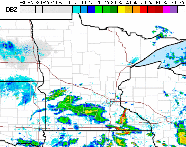
Meanwhile, most of northern Minnesota is already seeing skies clear and more sunshine.
The showers and storms in southern Minnesota continue to clear out west to east Friday morning into the afternoon. This includes a few showers and storms likely moving through the Twin Cities Friday morning. The southeastern edge of Minnesota could see storms linger long enough into the afternoon, that with daytime heating a few strong storms are possible.

Damaging winds and hail are the primary threat.
As storms move out, sunshine returns. High temperatures Friday range from the upper 70s north to the mid-80s south.

The month of June finishes with hot and unsettled weather. That forecast will be updated around 9:30 a.m.
Programming note
You can hear my live weather updates on Minnesota Public Radio at 7:48 a.m. Monday through Friday morning.
Turn Up Your Support
MPR News helps you turn down the noise and build shared understanding. Turn up your support for this public resource and keep trusted journalism accessible to all.

