
A gorgeous Saturday; PM rain chance Sunday
Sticky dew points Sunday afternoon
Go Deeper.
Create an account or log in to save stories.
Like this?
Thanks for liking this story! We have added it to a list of your favorite stories.


Today might be weather perfection. Our summery temps and reasonable dew points this Saturday will be accompanied by plenty of sunshine across most of Minnesota and western Wisconsin.
Our average Twin Cities high temperature on June 27 is 82 degrees. Twin Cities metro area temps will probably reach the upper 80s by late Saturday afternoon. Most of Minnesota and western Wisconsin will have Saturday highs in the 80s. A few spots in southwestern Minnesota could top 90. There may be a few 70s up along the North Shore of Lake Superior.
Sunday details
Sunday highs will reach the upper 80s in many areas:
Turn Up Your Support
MPR News helps you turn down the noise and build shared understanding. Turn up your support for this public resource and keep trusted journalism accessible to all.
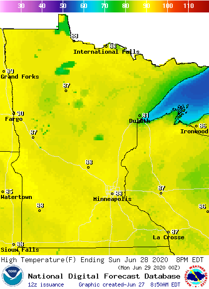
Highs could top 90 degrees in a few spots in southwestern Minnesota, while areas along the North Shore of Lake Superior may see highs closer to 80.
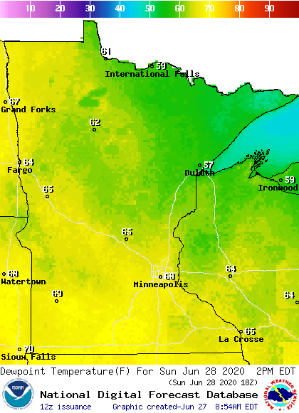
Sticky dew points in the mid to upper 60s spread across much of central and southern Minnesota Sunday afternoon:
Wind gusts of 20-25 mph are possible Sunday afternoon:
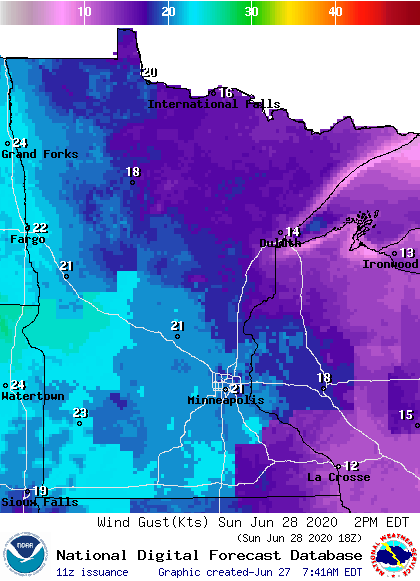
Plotted gusts are in knots, with 21 knots equal to 24 mph.
Sunday rain chances?
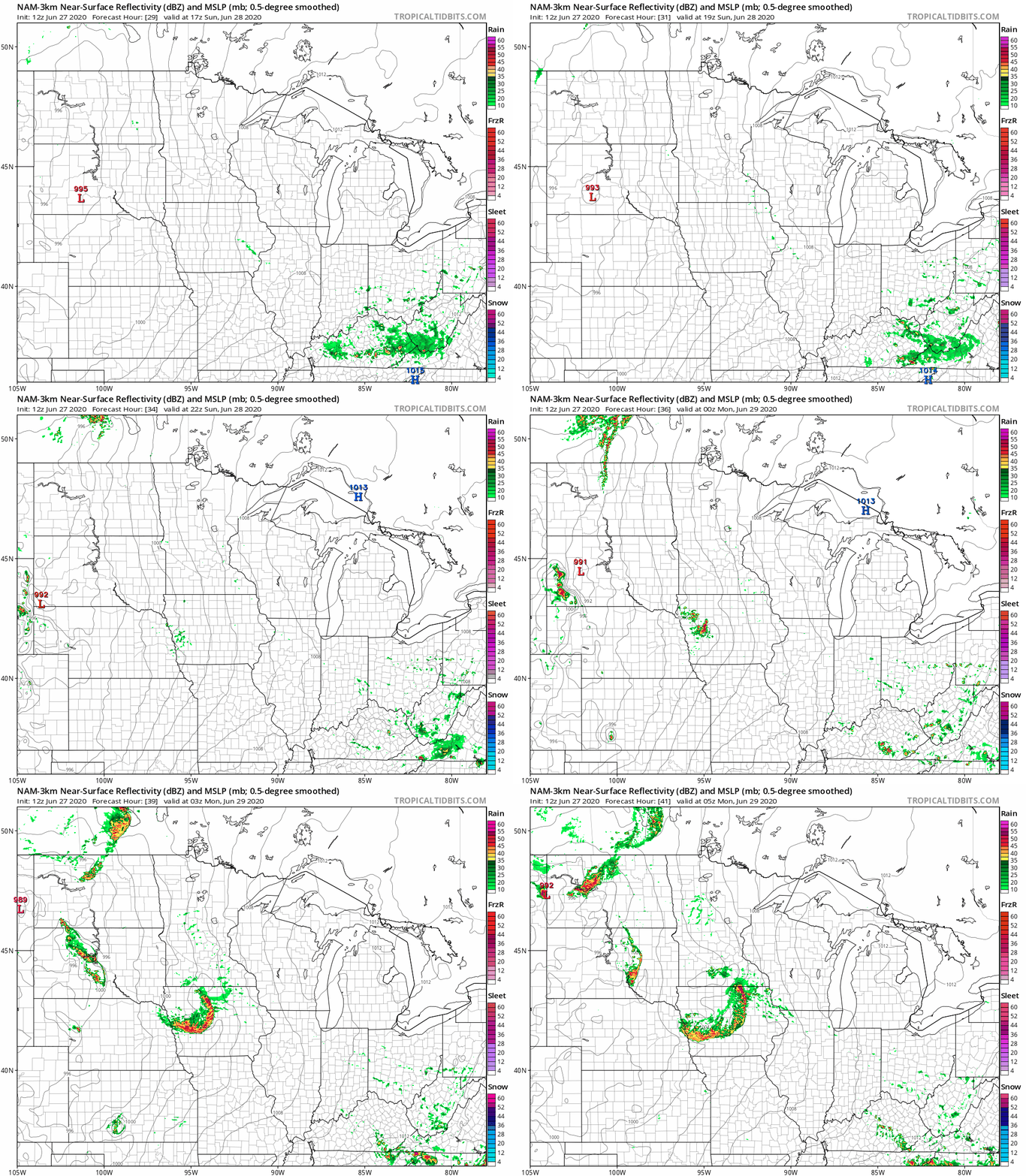
A stray show is possible Sunday morning in southwestern Minnesota. Scattered showers and some embedded thunderstorms are possible in Minnesota and western Wisconsin anytime from about mid-afternoon on Sunday into Sunday evening. We may see more numerous showers and thunderstorms overnight Sunday night.
The National Oceanic and Atmospheric Administration’s North American Mesoscale (NAM) forecast model shows the potential rain pattern for Sunday afternoon through Sunday evening:
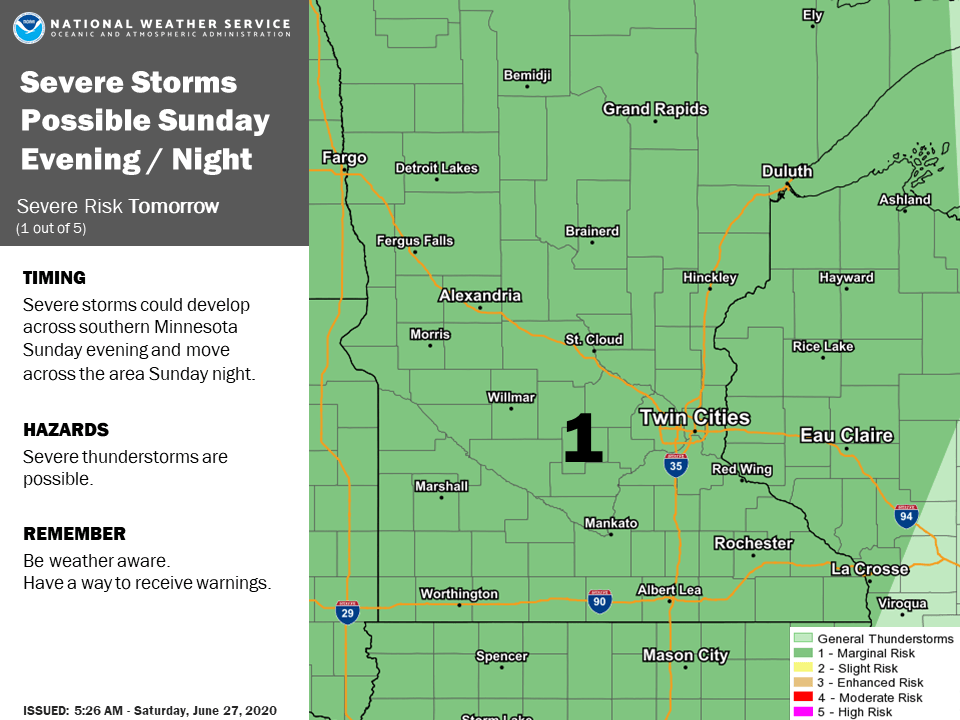
The NWS Storm Prediction Center shows a marginal risk of severe weather in Minnesota and western Wisconsin Sunday and Sunday night. Marginal risk means that an isolated severe thunderstorm is possible. Here’s the Twin Cities NWS discussion of the severe weather outlook:
You can hear updated weather information on the MPR network, and you’ll see updated weather info on the MPR News live weather blog.
The week ahead
Twin Cities highs are projected to reach the lower 90s Monday and Tuesday, followed by upper 80s Wednesday through Friday. We’ll have a chance of scattered showers/t-storms early Monday morning and also late Monday afternoon and Monday evening. There could be a few scattered showers and thunderstorms each day from Tuesday through Friday but we’ll have many dry hours too.
Flooding one year ago in southeastern Minnesota


Heavy rains caused flash flooding in parts of southeastern Minnesota one year ago.
Here’s the NWS summary of the June 27-28, 2019 event:
Thunderstorms developed in the evening hours of Thursday June 27th and intensified during the overnight hours. Parts of southeast Minnesota and the city of Rochester were the target of the heaviest rainfall. Rochester International Airport was closed for several hours overnight because of water over the runways where around 5" of rain fell in 6 hours. The hardest hit area was west of the city of Rochester, near Oxbow Park, where flash flooding on the Middle Fork of the Zumbro river swept away 40-60 cattle off one farm.
While some reports of people driving into flooded water were received, no lives were lost thankfully!
Rochester airport reported 5.63 inches of rain from the June 27-28 event, but there was a report of 7.25 inches in the Rochester area and 7.30 inches near Predmore, which is also in Olmsted County. Kasson, in Dodge County, tallied 7.50 inches of rain.
The Minnesota State Climatology Office also has a summary of the June 27-28, 2019 flooding event, including a radar loop.
Programming note
You can hear my live weather updates on MPR News at 7:35 a.m., 9:35 a.m. and 4:35 p.m. each Saturday and Sunday.

