
Steamy Monday; warm weather will linger through the weekend
Some impressive rain totals from Sunday evening
Go Deeper.
Create an account or log in to save stories.
Like this?
Thanks for liking this story! We have added it to a list of your favorite stories.


Sunday evening thunderstorms in east-central and southeastern Minnesota and western Wisconsin had meteorologists watching Doppler radar very closely. Severe weather spotters were scanning the skies, too. At one point, the NWS tower cam at La Crosse, Wisconsin added some insight into the storms:
There were preliminary reports of tornado touchdowns in Winona County on Sunday evening:

Times listed are Universal time, which is 5 hours ahead of Central Daylight Time. The listed time of 0139 equals 8:39 p.m. CDT. A NWS survey crew typically goes out the following day to survey the damage or the debris pattern and determine if there is evidence of a tornado.
Sunday evening thunderstorms delivered some impressive rain totals from central Minnesota into southeastern Minnesota and parts of western Wisconsin..
Turn Up Your Support
MPR News helps you turn down the noise and build shared understanding. Turn up your support for this public resource and keep trusted journalism accessible to all.
Many parts of the Twin Cities metro area saw downpours Sunday evening. Fleming Field Airport in South St. Paul tallied 1.10 inches of rain in less than one hour. There was a report of 3.34 inches of rain near Miesville, in Dakota County.
It’s been very dry in parts of central Minnesota, including St. Cloud, over the past few weeks. St. Cloud was running 2.61 inches below normal in June rainfall, but they saw some welcome rain Sunday evening:
Additional areas of thunderstorms are expected in central, southern and northeastern Minnesota plus western Wisconsin during the overnight hours of Sunday night. A few strong storms and areas of heavy rain are possible. There could even be some localized flooding.
You can hear updated weather information on the MPR network, and you’ll see updated weather info on the MPR News live weather blog.
Some lingering showers and thunderstorms are possible early Monday morning in eastern Minnesota and western Wisconsin, and there will also be a chance of a shower or thunderstorm later in the afternoon and in the evening.
Steamy Monday
Our average high temp in the Twin Cities is 82 degrees this time of year. Some spots in the metro area could top 90 degrees Monday afternoon.
Highs in the lower 90s are forecast on Monday for southern Minnesota, with upper 80s in central Minnesota and western Wisconsin:

There’ll be some 70s near the North Shore of Lake Superior.
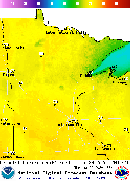
The Twin Cities metro area plus southern and central Minnesota and western Wisconsin will have dew points in the steamy 70s Monday afternoon:
It’ll also be a breezy Monday afternoon, with wind gusts of 17-25 mph:
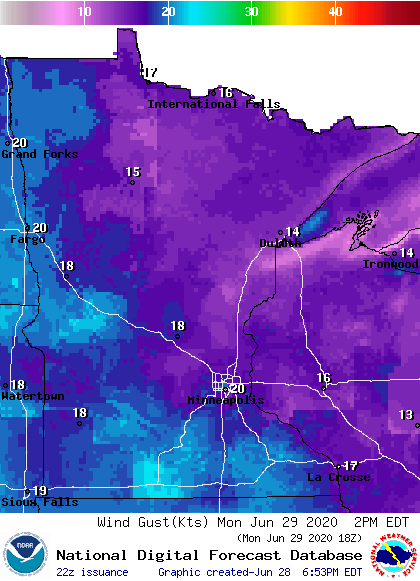
Plotted gusts are in knots, with 20 knots equal to 23 mph.
Temperature trends
Temps will be warm all week. Twin Cities metro area highs are projected to be in the lower 90s Tuesday, followed by upper 80s Wednesday and lower 90s Thursday and Friday. We may also see highs in the lower 90s on Saturday, which is the Fourth of July.
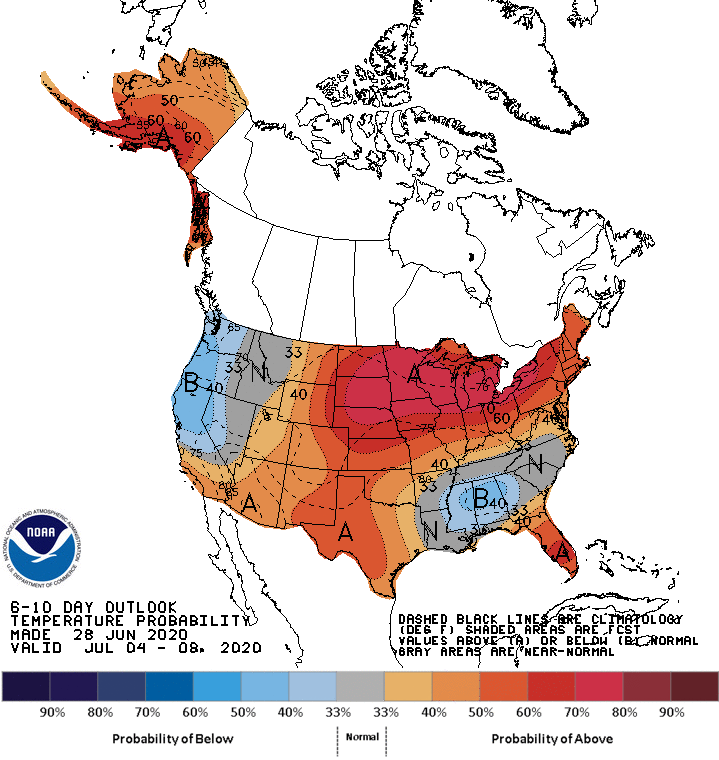
We’re also looking at a warm Sunday, and the warmth will linger into the following week. The NWS Climate Prediction Center shows a strong tendency toward above-normal temps in Minnesota and Wisconsin from July 4 through July 9:
I hope that you have a good week and a safe holiday weekend!

