
A gorgeous Sunday; thunderstorms return late Monday
A look back the incredible heat of July 1936
Go Deeper.
Create an account or log in to save stories.
Like this?
Thanks for liking this story! We have added it to a list of your favorite stories.


This will be a gorgeous Sunday across most of Minnesota and western Wisconsin. Far northwestern Minnesota and far northeastern Minnesota may see a stray rain shower.
Sunday highs reach the 80s across southern and central Minnesota and western Wisconsin, with some upper 70s in far northern Minnesota. Dew points will be in the 50s in many spots Sunday afternoon, with a few lower 60s in far southern Minnesota. I’d like to order up a few more days like today and keep them in storage for future use!
Monday PM thunder chances
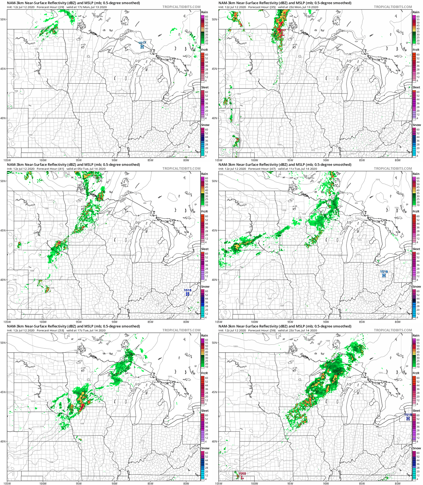
Scattered thunderstorms are possible in northwestern Minnesota Monday afternoon, with thunderstorms expanding across much of western Minnesota plus north-central Minnesota Monday evening, then eastward from there overnight Monday night. Periods of thunderstorms will linger into Tuesday in many areas.
Turn Up Your Support
MPR News helps you turn down the noise and build shared understanding. Turn up your support for this public resource and keep trusted journalism accessible to all.
The National Oceanic and Atmospheric Administration’s North American Mesoscale forecast model shows the potential rain pattern Monday afternoon through Tuesday afternoon:
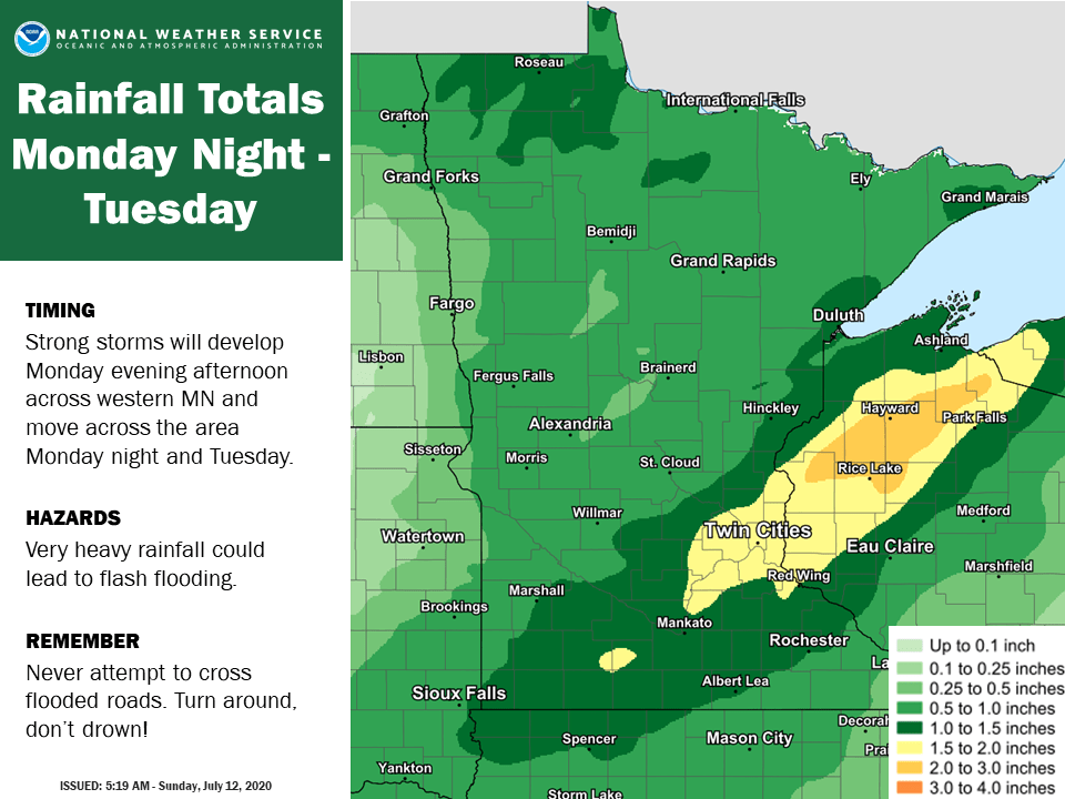
Rainfall totals from Monday night through Tuesday could reach 1.50 to 2 inches in the Twin Cities metro area, with even higher amounts in parts of northwestern Wisconsin:
You can hear updated weather information on the MPR network, and you’ll see updated weather info on the MPR News live weather blog.
The NWS Storm Prediction Center shows a slight risk of severe weather Monday and Monday night in roughly the northwestern half of Minnesota:
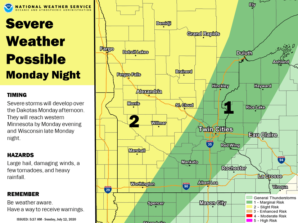
Slight risk means that scattered severe thunderstorms are possible. The risk of severe weather would be mainly Monday evening and overnight Monday night, but northwestern Minnesota could see a strong or severe thunderstorm a bit earlier than that.
The dark-green shaded area that includes the Twin Cities could see an isolated severe thunderstorm late Monday evening and overnight Monday night.
Temperature outlook
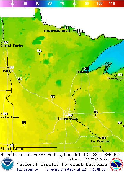
Monday highs will be well into the 80s across most of Minnesota and western Wisconsin:
Dew points will creep upward Monday afternoon, reaching the mid to upper 60s in western, central and southern Minnesota by 4 p.m.:
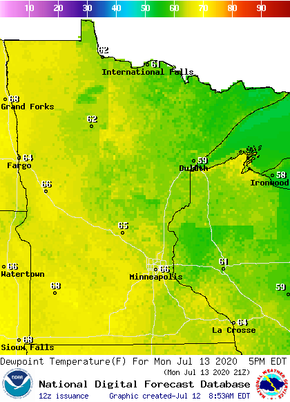
Back to high temperatures, Twin Cities metro area highs are projected to be around 80 on Tuesday, followed by lower 80s Wednesday, mid 80s Thursday and upper 80s on Friday and Saturday.
There aren’t any chilly temps in sight. Next Sunday and the following week look warm. The NWS Climate Prediction Center shows a tendency for above-normal temps in Minnesota and Wisconsin from July 19 through July 25:

Extremely hot in July 1936
Our average temp over the first 12 days of July 2020 is running 5.7 degrees warmer than normal in the Twin Cities.
It was much warmer in July of 1936. The Minnesota State Climatology Office has compiled some amazing stats about the sizzling heat of July 1936.
Here’s an excerpt:
In the Twin Cities, the high temperature was 90 degrees F or higher for 14 straight days, including 8 days with high temperatures at or above 100 degrees F. That's more 100-degree days than the Twin Cities recorded for all of the 1990s, 2000s, and 2010s combined!
The heat wave included five straight days with high temperatures at or above 105 in the Twin Cities, with an all-time record high of 108 F on the 14th, and seven straight days with low temperatures failing to fall below 80 degrees, with a low of just 86 F on July 13th. These measures of excessive heat are unmatched in records going back to late 1872.
The heat was not limited to the Twin Cities, or even to southern Minnesota, and exhibited a ferocity never before (or since) documented in central and even northern portions of the state. St. Cloud recorded nine 100-degree days (with a high of 107 F), Brainerd recorded six (including a high of 106 F), Cloquet recorded eight (high of 105 F), and the Grand Rapids Forestry Lab recorded six (high of 104 F). Even Duluth, famously "air-conditioned" by Lake Superior, recorded three 100-degree days, with a high temperature of 106 F on July 13th.
Twin Cities high temperature records for July 10 through July 14 that were set in 1936 still stand:

Programming note
You can hear my live weather updates on MPR News at 7:35 a.m., 9:35 a.m. and 4:35 p.m. each Saturday and Sunday.

