
Cooler and much less humid on Sunday!
Go Deeper.
Create an account or log in to save stories.
Like this?
Thanks for liking this story! We have added it to a list of your favorite stories.


The high temperature at Minneapolis-St. Paul International Airport was 91 degrees Saturday afternoon. With dew points in the upper 70s, we had a heat index of around 105 for a while.
The heat index was even higher in a few spots Saturday afternoon, including 116 at St. Peter:

You can check out additional heat index peaks here. Thankfully, our temperatures and dew points will be much lower on Sunday!
Late-Saturday storms in some areas
Turn Up Your Support
MPR News helps you turn down the noise and build shared understanding. Turn up your support for this public resource and keep trusted journalism accessible to all.
Thunderstorms bubbled up in parts of eastern Minnesota late Saturday afternoon and thunderstorm coverage expanded to include parts of western Wisconsin Saturday evening.
There were tornado warnings for a while late Saturday afternoon/early Saturday evening in northern and eastern Anoka County and northern Washington County. Radar-indicated rotation and spotter reports of funnel clouds prompted the warnings.
Here are some pics from Saturday:
There were a few reports of large hail Saturday evening:
Some areas had a rain-free Saturday evening, but some areas had downpours. That’s how thunderstorm season goes; thunderstorm coverage is often spotty.
At 9:53 p.m. Saturday, a tornado warning was issued for southeastern Washington County in Minnesota, plus northwestern Pierce County and southern St. Croix County in Wisconsin. A few minutes later, the NWS stated that there was confirmed tornado touch down near Prescott, Wisconsin.
The severe thunderstorm watch that was set to expire at 11 p.m. Saturday has been extended one hour for northwestern and west-central Wisconsin and it will expire at midnight. You can check with the NWS Storm Prediction Center for any additional severe weather watches that may be issued.
You can hear updated weather information on the MPR network, and you’ll see updated weather info on the MPR News live weather blog.
Comfortable weather returns on Sunday
Our average July 19 high temperature is 84 degrees in the Twin Cities. We’ll top out very close to 84 on Sunday, sharing highs in the 80s with much of Minnesota and western Wisconsin:
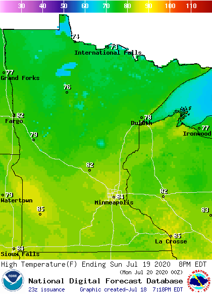
Far northern Minnesota will have Sunday highs in the 70s.
Dew points will be dropping on Sunday, reaching the 50s in most areas Sunday afternoon:
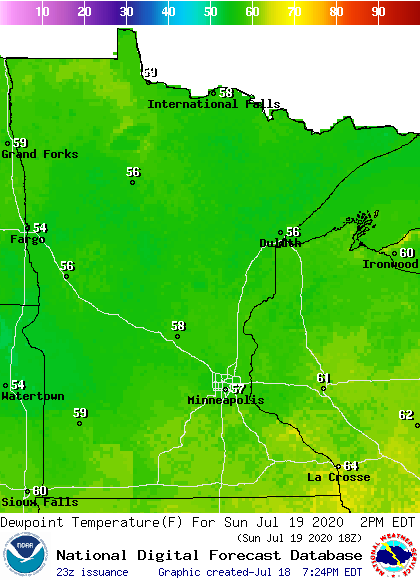
Dew points in the 60s will linger in western Wisconsin and far southeastern Minnesota.
Sunday will be breezy, with wind gusts of around 20-27 mph at times.
Temperature trends
Twin Cities metro area highs are projected to reach the lower 80s Monday and Tuesday, followed by mid 80s Wednesday, upper 80s Thursday and lower 90s on Friday. We could reach the lower 90s on Saturday too.
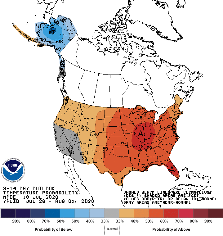
We may see warm weather from next Sunday right through the end of July and into August. The NWS Climate Prediction Center shows above-normal temperatures in Minnesota and western Wisconsin for July 26 through August 1:
Programming note
You can hear my live weather updates on MPR News at 7:35 a.m., 9:35 a.m. and 4:35 p.m. each Saturday and Sunday.

