
Steamy Saturday; strong storms possible late afternoon/evening
Severe weather is possible
Go Deeper.
Create an account or log in to save stories.
Like this?
Thanks for liking this story! We have added it to a list of your favorite stories.


Some of us are a bit sleep-deprived today, due to the thunderstorms that rumbled through overnight. Winds of 55-60 mph were noted in parts of the Twin Cities metro area as the storms moved through. Even stronger winds hit parts of northern Minnesota.
Storm reports from Friday evening and overnight can be found here. You can shift that storm report map to show more of northern Minnesota.
We expect to see thunderstorms develop later Saturday afternoon and Saturday evening in parts of southern, central and northeastern Minnesota plus western Wisconsin. Some severe weather is possible.
The National Weather Service Storm Prediction Center’s severe weather outlook for Saturday and Saturday night shows a slight risk (shaded yellow) of severe weather across much of Minnesota and Wisconsin:
Turn Up Your Support
MPR News helps you turn down the noise and build shared understanding. Turn up your support for this public resource and keep trusted journalism accessible to all.
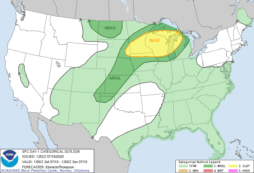
Slight risk means that scattered severe thunderstorms are possible. SPC will update the outlook later this morning and again this afternoon.
Here’s the Twin Cities NWS discussion of the severe weather potential:
_______________________________________________________________________________________
Midday update
The National Weather Service Storm Prediction Center has updated the severe weather outlook to an enhanced risk of severe weather (shaded beige) Saturday afternoon and Saturday night in most of the Twin Cities metro area and in additional areas to the west and north of the metro plus northwestern Wisconsin:
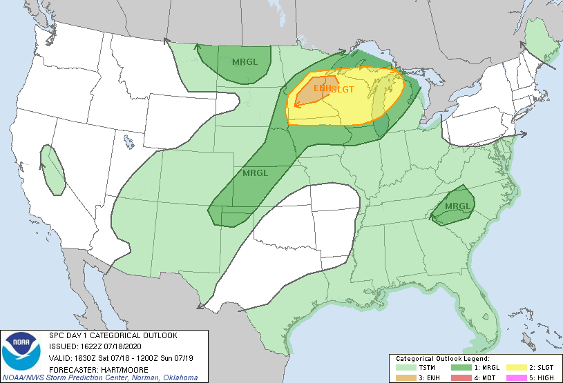
Enhanced risk means that numerous severe thunderstorms are possible. There is a slight risk of severe weather in the yellow-shaded areas.
The thunderstorm and severe weather risk in the Twin Cities metro area would tend to be late Saturday afternoon and Saturday evening.
Here are the severe weather categories that are used by the SPC:

Here’s an updated severe weather discussion from the Twin Cities office of the NWS:
__________________________________________________________________________________________
Stay sky-aware later this afternoon and this evening. You can hear updated weather information on the MPR network, and you’ll see updated weather info on the MPR News live weather blog.
Steamy Saturday
Saturday highs reach the 90s in the Twin Cities metro area and much of southern Minnesota and western Wisconsin. Saturday dew points will be well into the steamy 70s in central and southern Minnesota and western Wisconsin.
Due to expected heat index values in the 100 to 110 range, an excessive heat warning will run from 11 a.m. to 9.p.m. this Saturday for the Twin Cities metro area and much of southern Minnesota:
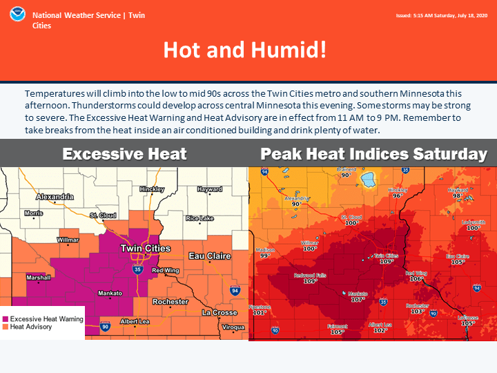
Southeastern Minnesota has a heat advisory from 1 p.m. to 8 p.m. this Saturday. The heat advisory in west central Wisconsin runs from 11 a.m. to 9 p.m. today.
Here are details of the excessive heat warning:
URGENT - WEATHER MESSAGE National Weather Service Twin Cities/Chanhassen MN 426 AM CDT Sat Jul 18 2020 MNZ059>063-065>070-073>077-082>084-091-181730- /O.CON.KMPX.EH.W.0002.200718T1600Z-200719T0200Z/ Wright-Hennepin-Anoka-Ramsey-Washington-Renville-McLeod-Sibley- Carver-Scott-Dakota-Redwood-Brown-Nicollet-Le Sueur-Rice-Watonwan- Blue Earth-Waseca-Martin- Including the cities of Monticello, Minneapolis, Blaine, St Paul, Stillwater, Olivia, Hutchinson, Gaylord, Chanhassen, Chaska, Victoria, Shakopee, Hastings, Redwood Falls, New Ulm, St Peter, Le Sueur, Faribault, St James, Mankato, Waseca, and Fairmont 426 AM CDT Sat Jul 18 2020 ...EXCESSIVE HEAT WARNING REMAINS IN EFFECT FROM 11 AM THIS MORNING TO 9 PM CDT THIS EVENING... * WHAT...Dangerously hot conditions with heat index values up to 110 expected. * WHERE...Portions of central, east central, south central and southwest Minnesota. * WHEN...From 11 AM this morning to 9 PM CDT this evening. * IMPACTS...Extreme heat and humidity will significantly increase the potential for heat related illnesses, particularly for those working or participating in outdoor activities. PRECAUTIONARY/PREPAREDNESS ACTIONS... Take extra precautions if you work or spend time outside. When possible, reschedule strenuous activities to early morning or evening. Know the signs and symptoms of heat exhaustion and heat stroke. Wear lightweight and loose-fitting clothing when possible and drink plenty of water. To reduce risk during outdoor work, the Occupational Safety and Health Administration recommends scheduling frequent rest breaks in shaded or air conditioned environments. Anyone overcome by heat should be moved to a cool and shaded location. Heat stroke is an emergency, call 9 1 1. An Excessive Heat Warning means that a prolonged period of dangerously hot temperatures will occur. The combination of hot temperatures and high humidity will combine to create a dangerous situation in which heat illnesses are likely. Drink plenty of fluids, stay in an air-conditioned room, stay out of the sun, and check up on relatives and neighbors. Young children and pets should never be left unattended in vehicles under any circumstances. This is especially true during warm or hot weather when car interiors can reach lethal temperatures in a matter of minutes.
Sunday will be cooler and less humid
Sunday highs will be mainly in the 80s, with some 70s in far northern Minnesota:
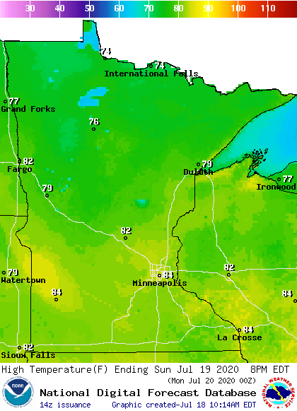
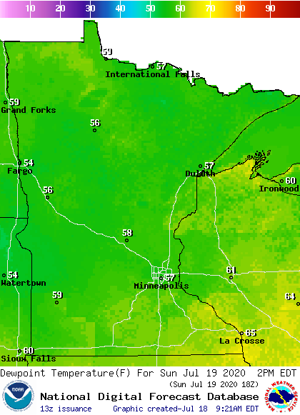
Sunday afternoon dew points will dip into the 50s in most areas, with some 60s in southeastern Minnesota plus western Wisconsin:
Temperature trends
Twin Cities metro area highs are projected to reach the lower 80s Monday and Tuesday, followed by mid 80s Wednesday, upper 80s Thursday and around 90 on Friday.
We may see warm weather from next weekend through the end of July. The NWS Climate Prediction Center shows above-normal temperatures in Minnesota and western Wisconsin for July 25 through July 31:
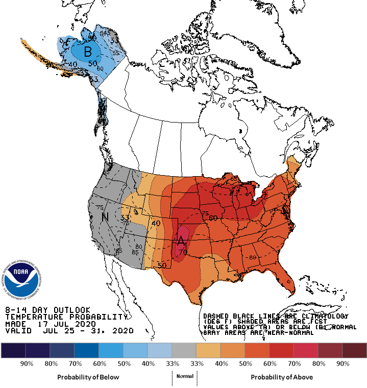
We’ll see if that pans out.
Programming note
You can hear my live weather updates on MPR News at 7:35 a.m., 9:35 a.m. and 4:35 p.m. each Saturday and Sunday.

