
Comfy temps, less wind on Monday; PM thunder chance far western Minn.
Steamy weather returns later this week
Go Deeper.
Create an account or log in to save stories.
Like this?
Thanks for liking this story! We have added it to a list of your favorite stories.


There wasn’t any weather drama on Sunday. We enjoyed comfortable temps and dew points.
Sunday’s weather was a nice change from the strong to severe thunderstorms that hit some areas Friday night and Saturday.
A National Weather Service storm survey team has determined that a tornado touch down occurred around 1 a.m. Saturday in the West Rush Lake area of northern Chisago County of Minnesota:
Jeremiah Sedler provided some pics of storm damage from that area:
Turn Up Your Support
MPR News helps you turn down the noise and build shared understanding. Turn up your support for this public resource and keep trusted journalism accessible to all.
The NWS storm survey team is also looking at some areas of apparent tornado damage that occurred Saturday evening from just east of Cottage Grove, Minnesota to near River Falls, Wisconsin. We’ll let you know the results of that storm survey when they become available.
___________________________________________________________________________________________
Update on storm survey
The NWS storm survey team has released preliminary results of their investigation:
Details of the survey can be found here.
The southern Washington county/Pierce county tornado of Saturday evening has been rated an EF-1, with peak winds estimated at 100 mph:
.SOUTHERN WASHINGTON COUNTY, MN INTO PIERCE COUNTY, WI TORNADO... RATING: EF-1 ESTIMATED PEAK WIND: 100 MPH PATH LENGTH /STATUTE/: 9.5 MILES PATH WIDTH /MAXIMUM/: 400 YARDS FATALITIES: 0 INJURIES: 0 START DATE: JUL 18 2020 START TIME: 953 PM CDT START LOCATION: 5 N HASTINGS, MN START LAT/LON: 44.8188 / -92.8441 END DATE: JUL 18 2020 END TIME: 1020 PM CDT END LOCATION: 2 SW RIVER FALLS, WI END LAT/LON: 44.8336 / -92.6571 EXTENSIVE TREE DAMAGE ALONG THE PATH, MANY OF WHICH WERE SNAPPED ABOUT HALF WAY UP. THE HEAVIEST DAMAGE OCCURRED ON TOP OF A BLUFF AS THE TORNADO CROSSED THE ST. CROIX RIVER INTO WISCONSIN. A FEW FARM OUTBUILDINGS WERE ALSO DAMAGED. EF SCALE: THE ENHANCED FUJITA SCALE CLASSIFIES TORNADOES INTO THE FOLLOWING CATEGORIES. EF0...WEAK......65 TO 85 MPH EF1...WEAK......86 TO 110 MPH EF2...STRONG....111 TO 135 MPH EF3...STRONG....136 TO 165 MPH EF4...VIOLENT...166 TO 200MPH EF5...VIOLENT...>200MPH NOTE: THE INFORMATION IN THIS STATEMENT IS PRELIMINARY AND SUBJECT TO CHANGE PENDING FINAL REVIEW OF THE EVENTS AND PUBLICATION IN NWS STORM DATA.
____________________________________________________________________________________________
Comet viewing opportunity

Evening cloud cover over Minnesota and western Wisconsin blocked our view of the comet NEOWISE the past few days. Viewing conditions will be much better Sunday evening.
Here are some NEOWISE details:
Why is it called Comet NEOWISE? It was discovered in March by a NASA space telescope that orbits the Earth. That space telescope is called the Near- Earth Object Wide-field Infrared Survey Explorer…NEOWISE.
Why is Comet NEOWISE special? …According to NASA, it is the brightest comet visible in the northern hemisphere since Comet Hale Bopp in 1996-97.
Can you see it with the naked eye? If you get far enough away from city lights you might be able to see it with the naked eye…otherwise you can use binoculars or a telescope.
Where do we look for it? It will be low in the sky, off to the northwest, below the big dipper. Make sure that buildings or trees don’t block your view of the sky above the horizon. Best viewing is an hour to an hour and a half after sunset.
Monday thunderstorm chances favor the far west
Parts of far western Minnesota could see scattered showers and t-storms late Monday afternoon and evening. The showers and thunderstorms are expected to spread into eastern Minnesota and western Wisconsin later Monday night.
The National Oceanic and Atmospheric Administration’s North American Mesoscale forecast model shows the potential rain pattern Monday afternoon through Monday evening:
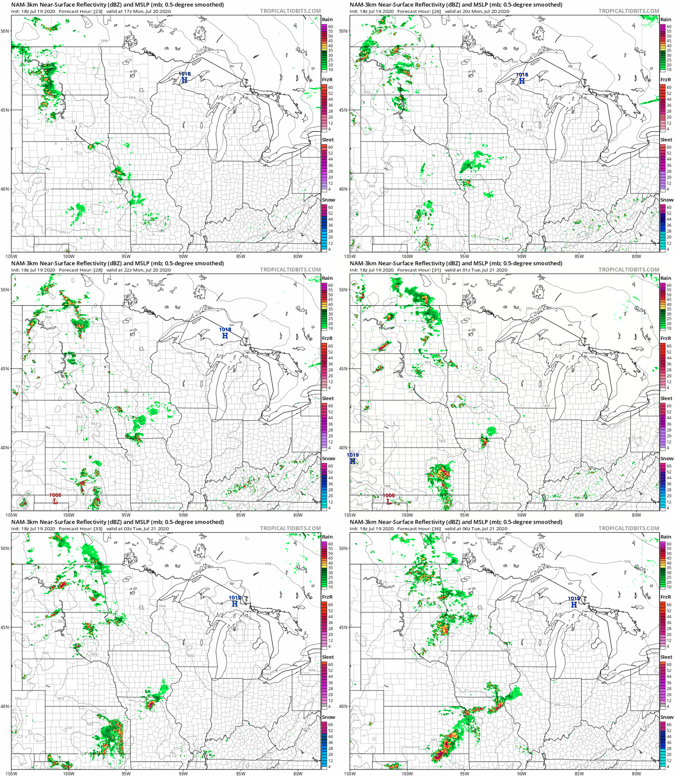
Some areas of showers of thunderstorms are expected in Minnesota and western Wisconsin on Tuesday.
You can hear updated weather information on the MPR network, and you’ll see updated weather info on the MPR News live weather blog.
Temperature trends
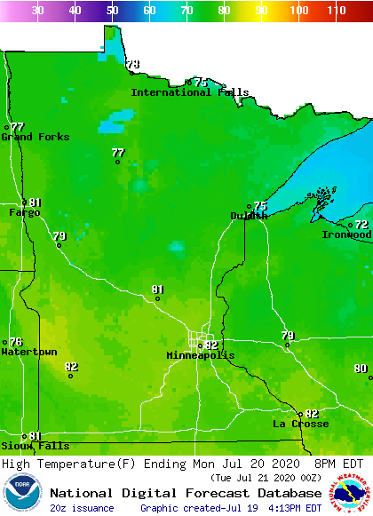
Monday highs will be in the 70s north, with lower 80s in central and southern Minnesota:
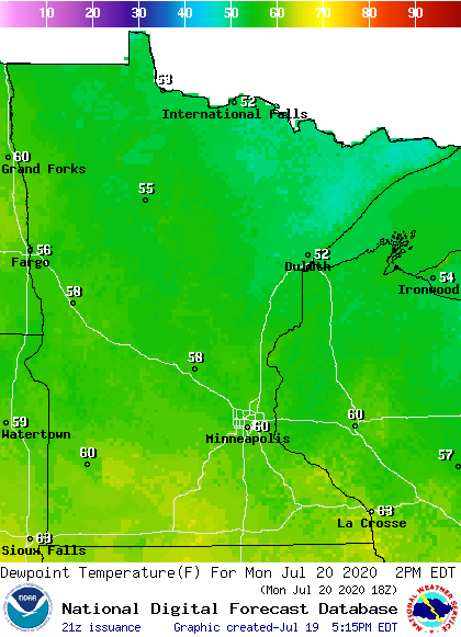
Monday afternoon dew points will be in the 50s in northern and central Minnesota, with a few lower 60s possible in the south:
Twin Cities metro area highs are projected to reach the lower 80s Tuesday and Wednesday, followed by mid 80s on Thursday and around 90 on Friday. We may see highs in the lower 90s next weekend. I should mention that dew points in the 70s are possible Friday and next weekend.
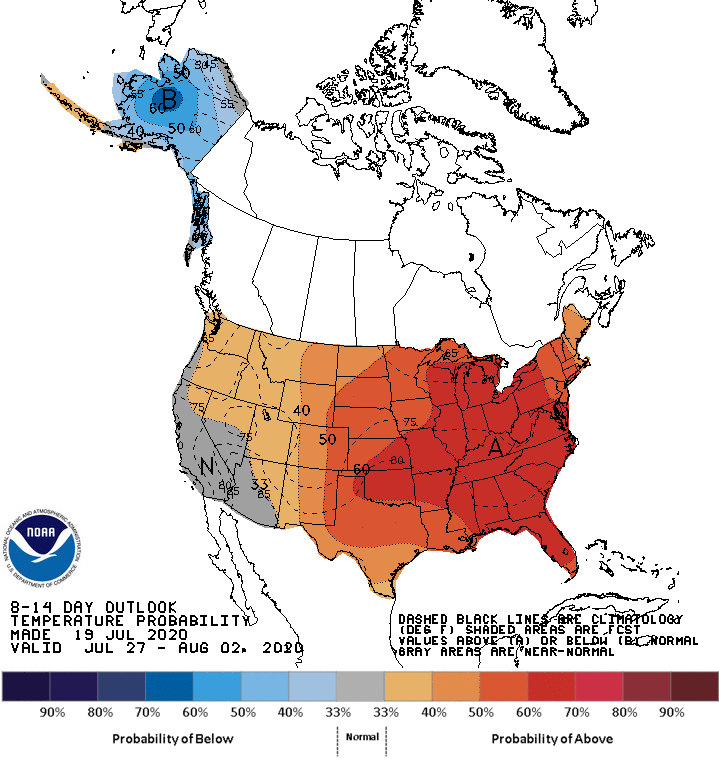
We may see warm weather from the following Monday through the end of July and into the first couple days in August. The NWS Climate Prediction Center shows a tendency for above-normal temperatures in Minnesota and western Wisconsin from July 27 through August 2:
I hope that you have a good week!

