
Weekend forecast: Steamy, thunderstorm chances highest Saturday
Severe weather is possible
Go Deeper.
Create an account or log in to save stories.
Like this?
Thanks for liking this story! We have added it to a list of your favorite stories.


I’ll get to the weekend shortly, but I’ll first give details on the heat advisories and excessive heat warnings that start at noon this Friday and run into Saturday evening.
Due to our combination of hot temperatures and high dew points, the National Weather Service has issued an excessive heat warning for the Twin Cities metro area from noon this Friday until 8 p.m. Saturday, with a heat advisory for much of western, central and south-central Minnesota:

Here are details of the metro area excessive heat warning:
URGENT - WEATHER MESSAGE National Weather Service Twin Cities/Chanhassen MN 710 AM CDT Fri Jul 24 2020 MNZ060>063-068>070-242100- /O.CON.KMPX.EH.W.0003.200724T1700Z-200726T0100Z/ Hennepin-Anoka-Ramsey-Washington-Carver-Scott-Dakota- Including the cities of Minneapolis, Blaine, St Paul, Stillwater, Chanhassen, Chaska, Victoria, Shakopee, and Hastings 710 AM CDT Fri Jul 24 2020 ...EXCESSIVE HEAT WARNING REMAINS IN EFFECT FROM NOON TODAY TO 8 PM CDT SATURDAY... * WHAT...Dangerously hot conditions with heat index values up to 103 expected. * WHERE...Scott, Washington, Ramsey, Anoka, Hennepin, Dakota and Carver Counties. * WHEN...From noon today to 8 PM CDT Saturday. * IMPACTS...Extreme heat and humidity will significantly increase the potential for heat related illnesses, particularly for those working or participating in outdoor activities. PRECAUTIONARY/PREPAREDNESS ACTIONS... Drink plenty of fluids, stay in an air-conditioned room, stay out of the sun, and check up on relatives and neighbors. Young children and pets should never be left unattended in vehicles under any circumstances. Take extra precautions if you work or spend time outside. When possible reschedule strenuous activities to early morning or evening. Know the signs and symptoms of heat exhaustion and heat stroke. Wear lightweight and loose fitting clothing when possible. To reduce risk during outdoor work, the Occupational Safety and Health Administration recommends scheduling frequent rest breaks in shaded or air conditioned environments. Anyone overcome by heat should be moved to a cool and shaded location. Heat stroke is an emergency! Call 9 1 1.
Turn Up Your Support
MPR News helps you turn down the noise and build shared understanding. Turn up your support for this public resource and keep trusted journalism accessible to all.
There is also an excessive heat warning from noon Friday until 8 p.m. Saturday for several northwestern Minnesota counties, with heat advisories in the remainder of northwestern and west-central Minnesota:

Here are details of the excessive heat warning that includes Moorhead, Minnesota:
URGENT - WEATHER MESSAGE National Weather Service Grand Forks ND 326 AM CDT Fri Jul 24 2020 MNZ001>003-029-NDZ027-029-030-038-039-049-052-053-250100- /O.UPG.KFGF.EH.A.0001.200724T1700Z-200725T0100Z/ /O.NEW.KFGF.EH.W.0001.200724T1700Z-200725T0100Z/ West Polk-Norman-Clay-Wilkin-Grand Forks-Steele-Traill-Barnes- Cass-Ransom-Sargent-Richland- Including the cities of Crookston, East Grand Forks, Ada, Twin Valley, Halstad, Moorhead, Breckenridge, Grand Forks, Finley, Hope, Mayville, Hillsboro, Hatton, Portland, Valley City, Fargo, Lisbon, Enderlin, Gwinner, Milnor, Forman, Rutland, and Wahpeton 326 AM CDT Fri Jul 24 2020 ...EXCESSIVE HEAT WARNING IN EFFECT FROM NOON TODAY TO 8 PM CDT THIS EVENING... * WHAT...Dangerously hot conditions with heat index values around 105 expected. * WHERE...Portions of northwest and west central Minnesota and northeast and southeast North Dakota. * WHEN...From noon today to 8 PM CDT this evening. * IMPACTS...Extreme heat and humidity will significantly increase the potential for heat related illnesses, particularly for those working or participating in outdoor activities. PRECAUTIONARY/PREPAREDNESS ACTIONS... Drink plenty of fluids, stay in an air-conditioned room, stay out of the sun, and check up on relatives and neighbors. Young children and pets should never be left unattended in vehicles under any circumstances. Take extra precautions if you work or spend time outside. When possible reschedule strenuous activities to early morning or evening. Know the signs and symptoms of heat exhaustion and heat stroke. Wear lightweight and loose fitting clothing when possible. To reduce risk during outdoor work, the Occupational Safety and Health Administration recommends scheduling frequent rest breaks in shaded or air conditioned environments. Anyone overcome by heat should be moved to a cool and shaded location. Heat stroke is an emergency! Call 9 1 1.
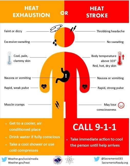
Take it easy the next few days, and be aware of the warning signs of heat exhaustion and heat stroke:
Friday night thunderstorms
Scattered thunderstorms are expected to move into western Minnesota Friday evening, then spread eastward during the overnight hours of Friday night.
The National Weather Service Storm Prediction Center shows a slight risk (shaded yellow) of severe weather in a portion of far western Minnesota Friday/Friday night:
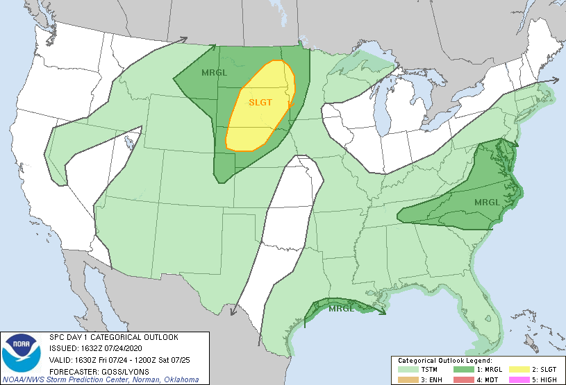
Slight risk means that scattered severe thunderstorms are possible. Friday night lasts until 7 a.m. Saturday in the SPC outlook. The dark-green shaded area in the remainder of western Minnesota indicates a marginal risk of severe weather, meaning that an isolated severe thunderstorm is possible.
Steamy weekend
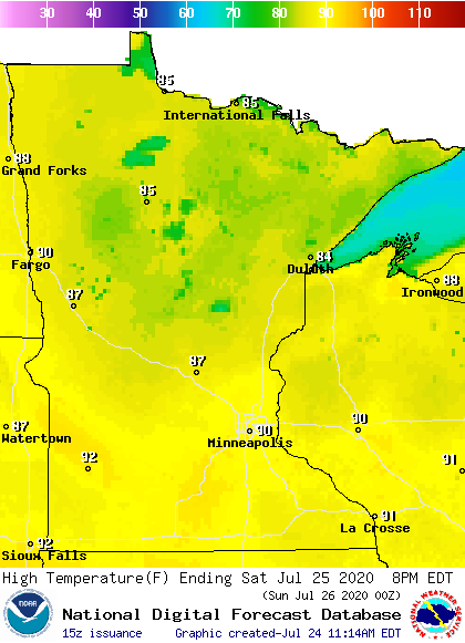
Our average Twin Cities high temperature is 83 degrees this time of year. We could hit 90 degrees in the metro area Saturday afternoon.
Highs in the lower 90s are forecast for southern Minnesota on Saturday, with 80s in most of central and northern Minnesota:
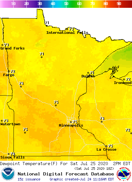
Saturday dew points will be in the steamy 70s in most areas:
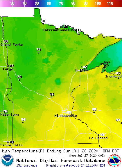
Sunday highs cool to the 70s northwest, with some upper 80s southeast:
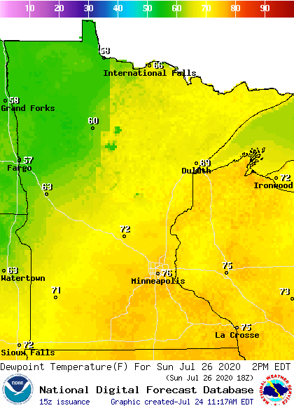
Sunday afternoon dew points are still in the 70s in central and southern Minnesota, plus western Wisconsin:
Thunderstorm chances
Scattered thunderstorms could linger into Saturday morning in Minnesota and western Wisconsin, followed by additional areas of thunderstorms from Saturday afternoon into Saturday night. Some areas could see heavy rain Saturday and Saturday night, and severe weather will also be possible. Stay sky-aware this weekend, and make sure that you have a way to receive weather warnings.
Scattered thunderstorms are possible Sunday morning, then some forecast models keep Sunday afternoon/evening thunderstorm chances confined mainly to the southeastern half of Minnesota plus western Wisconsin. That could change.
You can hear updated weather information on the MPR network, and you’ll see updated weather info on the MPR News live weather blog.

