
A steamy Saturday; thunderstorm chances increase tonight
A severe t-storm will be possible
Go Deeper.
Create an account or log in to save stories.
Like this?
Thanks for liking this story! We have added it to a list of your favorite stories.


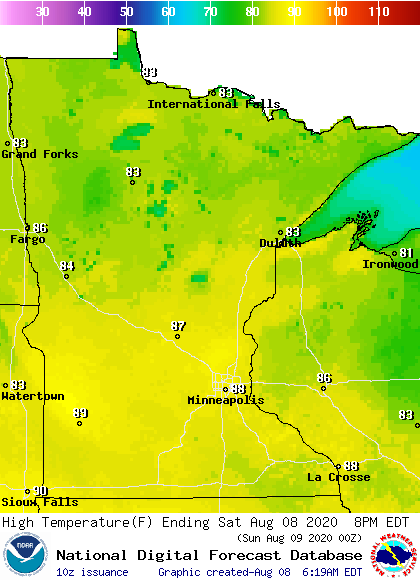
It felt like early autumn for several days this past week. We now have an emphatic return to summery weather.
Saturday highs will be well into the 80s in most areas:
Dew points will be in the steamy 70s in most locations, with 60s in parts of northwestern Minnesota by afternoon:

Thunderstorm chances
Turn Up Your Support
MPR News helps you turn down the noise and build shared understanding. Turn up your support for this public resource and keep trusted journalism accessible to all.
A few thunderstorms are rolling across parts of far northern Minnesota this Saturday morning, with a few scattered showers in the south. There will be a chance of an isolated thunderstorm in the early afternoon in parts of Minnesota and western Wisconsin, with scattered thunderstorms possible later this afternoon and Saturday evening. More widespread thunderstorms are possible overnight.
The National Weather Service Storm Prediction Center shows a slight risk of severe weather (shaded yellow) Saturday and Saturday night in southwestern Minnesota, with a marginal risk of severe weather (dark green) across much of Minnesota and Wisconsin:

Slight risk means that scattered severe thunderstorms are possible, while marginal risk means that an isolated severe thunderstorm is possible:

You can hear updated weather information on the MPR network, and you’ll see updated weather info on the MPR News live weather blog.
This Updraft blog will be updated by around 10 a.m. with updated info on your Sunday weather and a look at the week ahead.
Programming note
You can hear my live weather updates on MPR News at 7:35 a.m., 9:35 a.m. and 4:35 p.m. each Saturday and Sunday.

