
Quiet Saturday in most areas, thunderstorms possible in northern Minn.
Recap of Friday severe weather
Go Deeper.
Create an account or log in to save stories.
Like this?
Thanks for liking this story! We have added it to a list of your favorite stories.


Strong to severe thunderstorms swept across much of Minnesota and parts of western Wisconsin Friday and Friday evening.
There were at least 9 tornados in Minnesota on Friday, according to the National Weather Service Storm Prediction Center web site:

That’s the preliminary tornado tally, and NWS storm survey crews will give updated info when it becomes available. Listed times are in Universal time, which is 5 hours ahead of CDT. For example, 2038 is 3:38 p.m. CDT.
This tornado was near Brownton in McLeod County around 5:45 p.m. on Friday:
Turn Up Your Support
MPR News helps you turn down the noise and build shared understanding. Turn up your support for this public resource and keep trusted journalism accessible to all.
The Twin Cities NWS office announced today that they will be sending out a storm survey team to look at the Friday evening storm damage in Crystal and Robbinsdale. The NWS survey team will also look at damage in Meeker and McLeod counties.
_________________________________________________________________________________________
Afternoon update
The NWS storm survey team determined that an EF-0 touched down briefly Friday evening near Crystal, Minnesota:
Here’s a closer look:

______________________________________________________________________________________
You can find more info on Friday storm damage in Minnesota, as well as some large hail reports, here.
Thunderstorm chance north
Much of Minnesota and western Wisconsin can expect quiet weather this Saturday. Scattered thunderstorms are possible in roughly the northern third of Minnesota later Saturday afternoon and Saturday evening. Some of those thunderstorms could clip parts of northwestern Wisconsin by evening.
The NWS Storm Prediction Center shows a slight risk (shaded yellow) of severe weather in portions of northern Minnesota Saturday afternoon and Saturday night:

Here’s a closer look at the severe weather potential, from the Duluth NWS office:

You can hear updated weather information on the MPR network, and you’ll see updated weather info on the MPR News live weather blog.
________________________________________________________________________________________
4 p.m. update
The NWS Storm Prediction Center has issued a severe thunderstorm watch valid until 11 p.m. for portions of northern Minnesota:
__________________________________________________________________________________________
One forecast model also shows scattered thunderstorm chances Sunday afternoon and Sunday evening in far southern Minnesota plus western Wisconsin.
Comfortable temperatures and humidity
Saturday highs will be in the 70s in much of Minnesota and western Wisconsin. There could be a few lower 80s in far western Minnesota and far southern Minnesota. Twin Cities metro area highs are expected to be around 80. Dew points will be mainly in the comfortable 50s this Saturday afternoon.
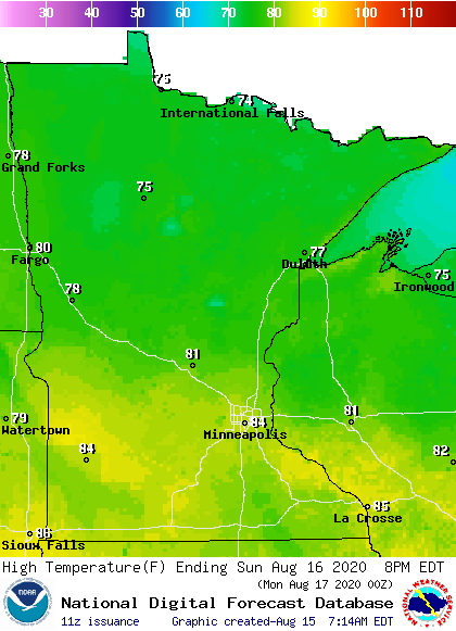
Sunday highs range from the mid 70s in far northern Minnesota to the mid 80s in the far south:
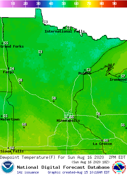
Dew points will be in the 50s in most spots:
Back to high temperatures, Twin Cities metro area highs are projected to reach the upper 70s on Monday, followed by highs in the lower 80s Tuesday through Friday.
Programming note
You can hear my live weather updates on MPR News at 7:35 a.m., 9:35 a.m. and 4:35 p.m. each Saturday and Sunday.

