
A steamy Sunday
Two hurricanes may hit Louisiana this week
Go Deeper.
Create an account or log in to save stories.
Like this?
Thanks for liking this story! We have added it to a list of your favorite stories.


I’ll bet that a few people were wondering if summer was over when we had those highs in the 70s a few days ago. Not so fast; summery weather has returned and it’ll stay with us for several more days.
Our average Twin Cities high temperature is 80 degrees this time of year, but the metro area will probably reach the upper 80s Sunday afternoon. Highs will be well into the 80s in most spots on Sunday, with some 90s in southwestern Minnesota:
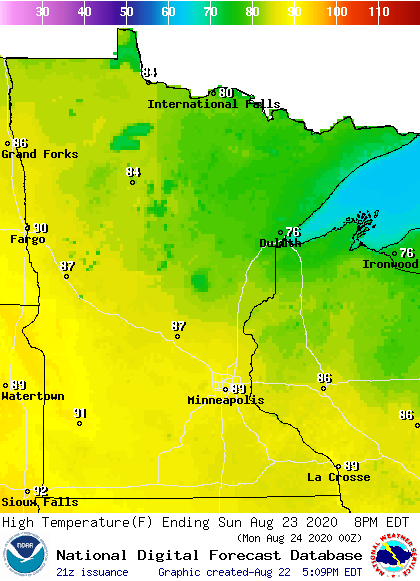
Northeastern Minnesota will see a few 70s.
Sunday afternoon dew points will be in the upper 60s in many locations, so it’ll feel steamy:
Turn Up Your Support
MPR News helps you turn down the noise and build shared understanding. Turn up your support for this public resource and keep trusted journalism accessible to all.
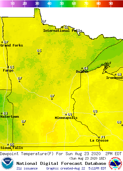
The dew point may even top 70 degrees at times in some locations.
Temperature trends
Twin Cities metro area highs are projected to hit around 90 on Monday and Tuesday, followed by lower 90s Wednesday, mid 80s Thursday and lower 80s on Friday.
Thunderstorm chances
The best chance of scattered thunderstorms this Saturday evening will be from north-central and northeastern Minnesota into the northwestern corner of Wisconsin. A few more isolated thunderstorms are also possible Saturday evening elsewhere in Minnesota and in the remainder of western Wisconsin. Stay sky-aware Saturday evening.
You can hear updated weather information on the MPR network, and you’ll see updated weather info on the MPR News live weather blog.
Two hurricanes this week?
Two hurricanes may make landfall along the Louisiana coast this coming week.
According to the NWS National Hurricane Center, Tropical Storm Marco was centered 50 miles west of the western tip of Cuba Saturday afternoon. Marco is forecast to become a hurricane Saturday night and it could make landfall on Monday along the the Louisiana or Mississippi coast:

The cone surrounding the forecast track indicates the uncertainty in the forecast track of Marco’s center.
Hurricane watches have been posted along the Louisiana and Mississippi coasts.
Tropical Storm Laura was 100 miles west of Ponce, Puerto Rico Saturday afternoon. Laura is forecast to become a hurricane before making landfall on Wednesday somewhere along the Louisiana coast:
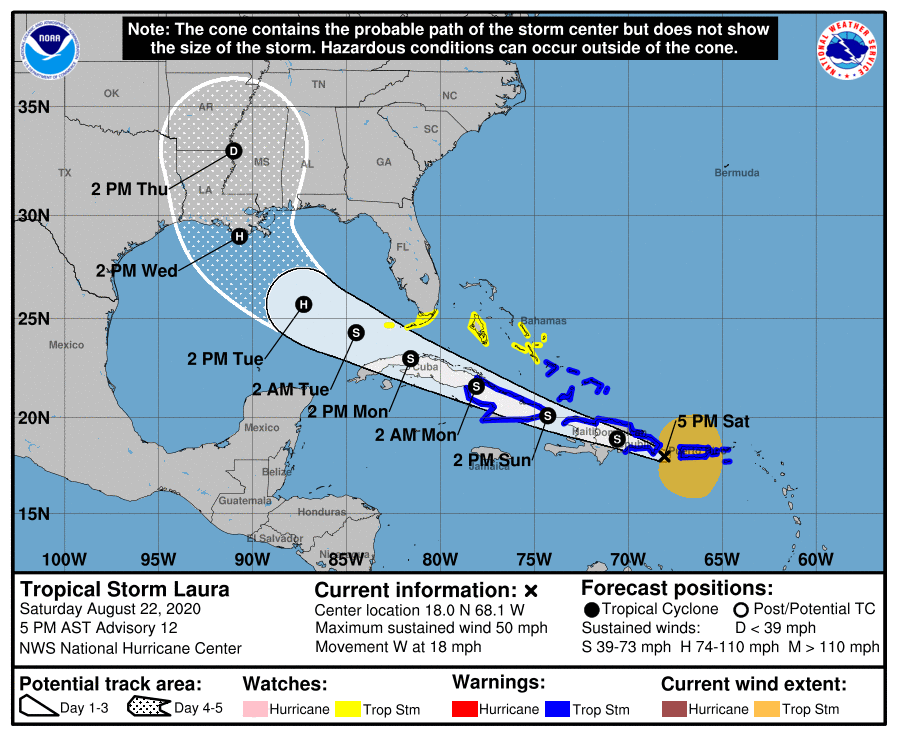
The National Hurricane Center issues tropical updates every 3 hours.
Programming note
You can hear my live weather updates on MPR News at 7:35 a.m., 9:35 a.m. and 4:35 p.m. each Saturday and Sunday.

