
Steamy again on Monday, with thunderstorm chances increasing PM
Hurricane Marco update
Go Deeper.
Create an account or log in to save stories.
Like this?
Thanks for liking this story! We have added it to a list of your favorite stories.


The official Sunday high temperature at Minneapolis-St. Paul International Airport was 91 degrees. Yea, that’s hot. Our average August 23 Twin Cities high temp is only 80 degrees. We had sticky dew points too.
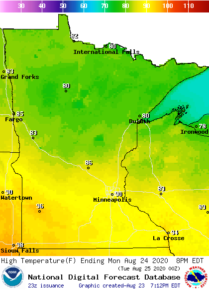
Monday will be very warm in central and southern Minnesota and much of western Wisconsin, with cooler highs in northern Minnesota:
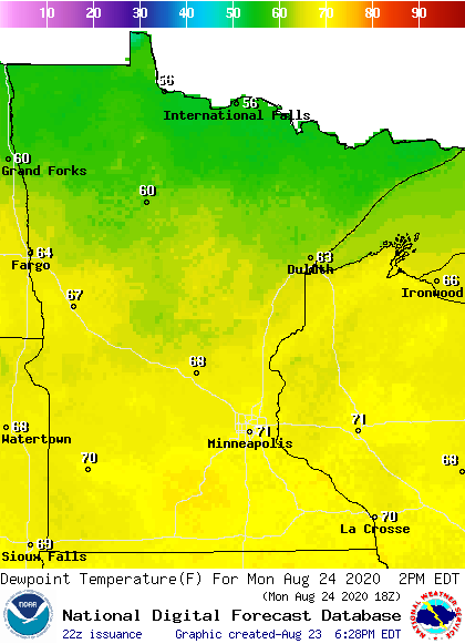
Dew points will be sticky in the warmest areas Monday afternoon:
Twin Cities metro area highs are projected to be around 90 on Monday, followed by upper 80s Tuesday and around 90 on Wednesday. Cooler highs will follow, with mid 80s Thursday and lower 80s on Friday.
Turn Up Your Support
MPR News helps you turn down the noise and build shared understanding. Turn up your support for this public resource and keep trusted journalism accessible to all.
Thunderstorm chances
Northwestern and west-central Minnesota will have the best chance of scattered thunderstorms Sunday evening. Thunderstorm chances expand over much of the northern half of Minnesota plus northwestern Wisconsin during the overnight hours Sunday night. Some locations could see a severe thunderstorm.
It looks like the Twin Cities metro area and west-central Wisconsin may see an isolated thunderstorm anytime between about midnight Sunday night and 8 a.m. or so on Monday.
You can hear updated weather information on the MPR network, and you’ll see updated weather info on the MPR News live weather blog.
Areas of thunderstorms are also expected to develop later Monday afternoon and Monday evening. The NWS Storm Prediction Center shows a slight risk of severe thunderstorms Monday and Monday night from the Twin Cities metro area into parts of southeastern Minnesota and western Wisconsin. The Twin Cities NWS office posted this depiction of the severe weather potential:
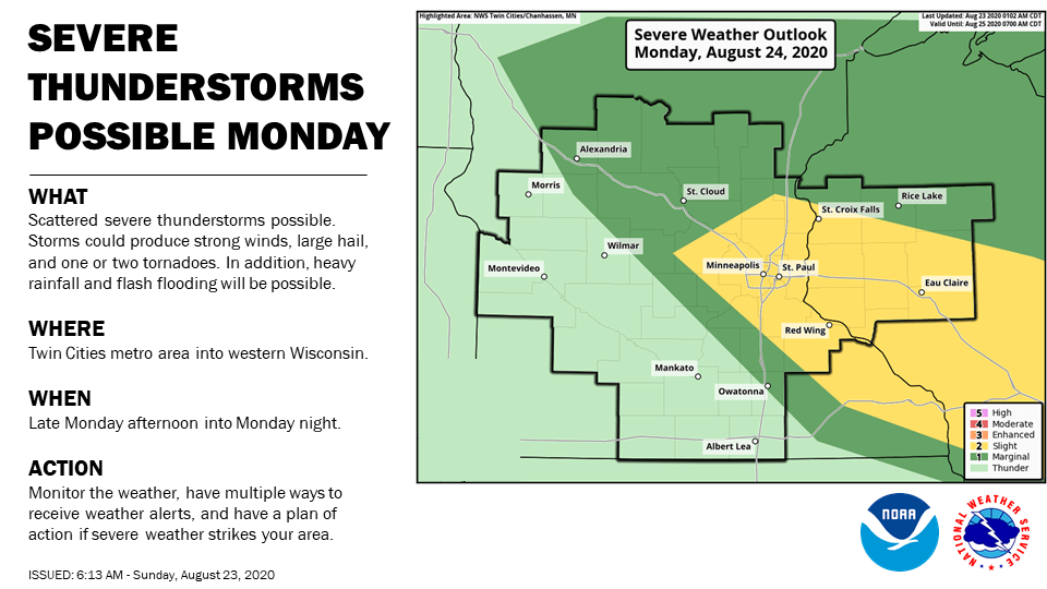
The slight risk area, which is shaded yellow, indicates where scattered severe thunderstorms will be possible Monday and Monday night. Isolated severe storms are possible in the marginal risk area, which is shaded dark-gree.
It looks like the Monday severe weather risk will be mainly from late Monday afternoon into Monday evening, but check forecast updates.
Reddish-orange sunsets
You may have noticed a milky veil covering parts of the sky Sunday afternoon. It was the leading edge of some smoke from California wildfires. The smoke is at upper altitudes, and it isn’t expected to create significant air quality issues at ground level. The smoke will probably add some reddish-orange highlights to our sunsets and sunrises over the next few days.
Two hurricanes this week
Two hurricanes may make landfall along the Louisiana coast this week.
According to the NWS National Hurricane Center, Hurricane Marco was centered 240 miles south-southeast of the mouth of the Mississippi River Sunday afternoon. Marco is forecast to make landfall on Monday along the Louisiana coast:
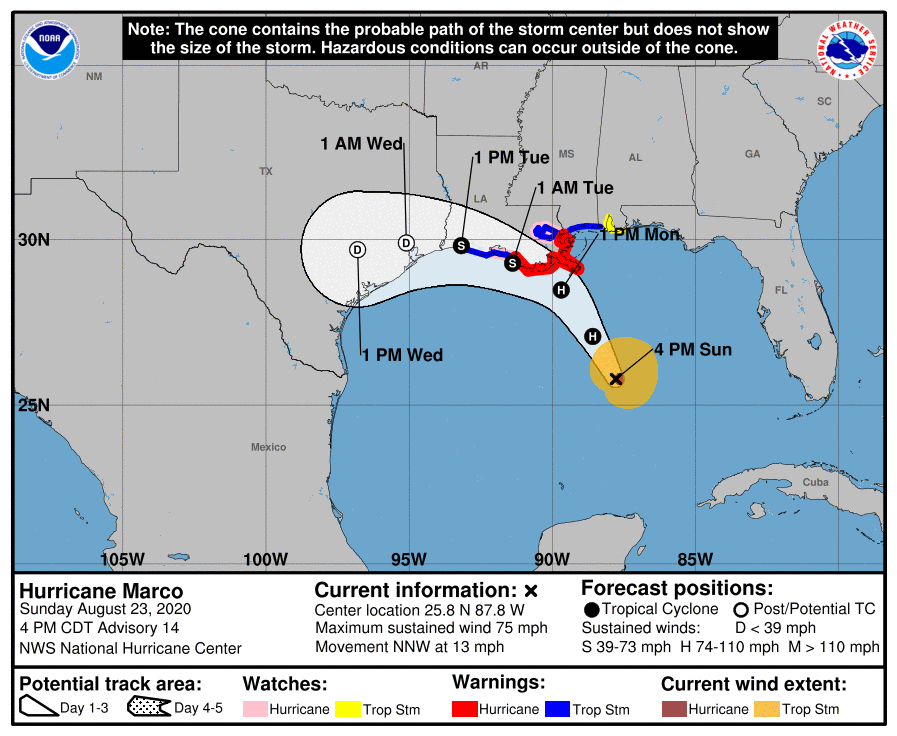
The cone surrounding the forecast track indicates the uncertainty in the forecast track of Marco’s center.
Hurricane warnings have been issued along portions of the Louisiana and Mississippi coasts.
The National Hurricane Center states that the center of Tropical Storm Laura was 50 miles south of Guantanamo, Cuba Sunday afternoon. Laura is expected to reach hurricane strength before making landfall on Wednesday somewhere along the Louisiana or Texas coast:
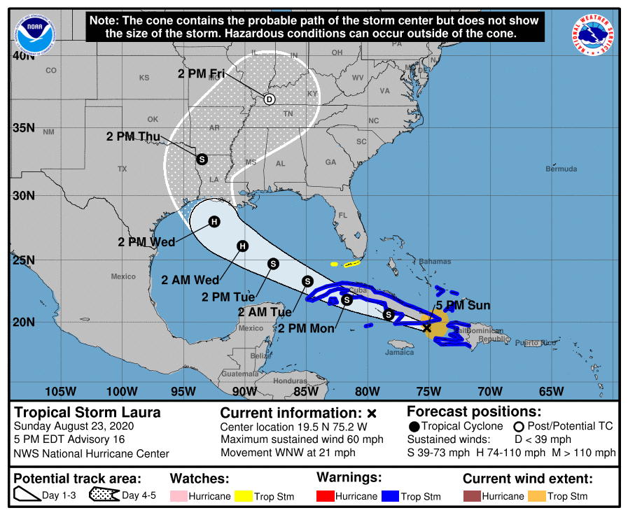
Records dating back to 1851 don’t show two hurricanes ever before making landfall along the U.S. Gulf Coast in such a short time span:
The National Hurricane Center issues tropical updates every 3 hours.
Programming note
You can hear my live weather updates on MPR News at 7:35 a.m., 9:35 a.m. and 4:35 p.m. each Saturday and Sunday.

