
Strong storms possible late Thursday
One last warm, humid day in southern Minnesota
Go Deeper.
Create an account or log in to save stories.
Like this?
Thanks for liking this story! We have added it to a list of your favorite stories.


Thursday stays above average across the state but not as hot as recent days, and strong storms move in late.
Thursday’s forecast
Behind a front that moved through most of the state Wednesday, and is lingering in southern Minnesota as of Thursday morning, northern Minnesota is starting of noticeably cooler, with lows in the 50s. Meanwhile, the southern edge of the state is still seeing 60s and 70s.
That temperature contrast holds in the afternoon too, with the northern half of the state seeing more seasonable 70s for highs, while southern Minnesota has temperatures in the 80s and possibly a couple isolated 90s.
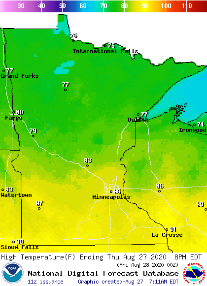
After areas of morning fog from central to southwestern Minnesota burn off, most of the day stays sunny and dry.
Then, in the late afternoon, showers and storms start pushing into northwestern Minnesota and spread wet weather across the state by late Thursday.
Turn Up Your Support
MPR News helps you turn down the noise and build shared understanding. Turn up your support for this public resource and keep trusted journalism accessible to all.
Some storms are likely to be severe, especially across southern Minnesota.

For the Twin Cities, the most likely timing for any storms is overnight through Friday morning.
Behind that weather system, temperatures turn cooler into next week.
That extended forecast will be updated around 9 a.m.
Programming note
You can hear my live weather updates on Minnesota Public Radio at 7:48 a.m. Monday through Friday morning.

