
Friday starts off stormy and wet
Southeastern Minnesota sees a severe weather risk
Go Deeper.
Create an account or log in to save stories.
Like this?
Thanks for liking this story! We have added it to a list of your favorite stories.


A broad area of showers and storms is moving across the state Friday, while temperatures return closer to average for late August.
Friday’s forecast
A storm system impacting Minnesota is bringing widespread showers and storms Friday morning.
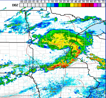
These storms also bring an chance for severe weather to the southeastern corner of the state both in the morning and again later in the afternoon as storms intensify once more.

For the rest of Minnesota, most of the active weather occurs Friday morning, then showers and storms become spottier in the afternoon as the precipitation clears out west to east.
Turn Up Your Support
MPR News helps you turn down the noise and build shared understanding. Turn up your support for this public resource and keep trusted journalism accessible to all.
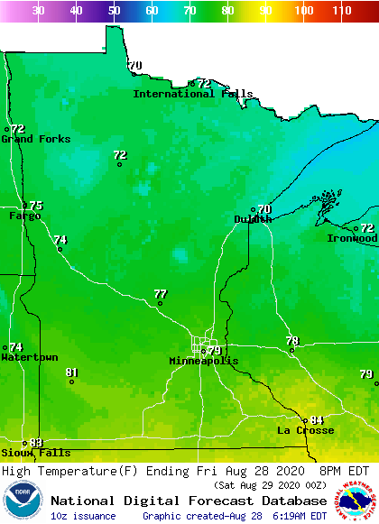
Much of Minnesota is starting Friday in the 60s, and highs will be closer to average than the recent warm weather, with temperatures in the 70s and low 80s.
As the storm system moves through, winds are switching around to the northwest and will be breezy, especially in western Minnesota by afternoon.
That wind flow draws in even cooler weather for Saturday.
The extended forecast, including upcoming temperatures, will be updated around 9 a.m.
Programming note
You can hear my live weather updates on Minnesota Public Radio at 7:48 a.m. Monday through Friday morning.

