
Sunday night showers/t-storms; breezy and cooler on Monday
Last day of meteorological summer
Go Deeper.
Create an account or log in to save stories.
Like this?
Thanks for liking this story! We have added it to a list of your favorite stories.


Our Sunday high of 78 degrees at Minneapolis-St. Paul International Airport was equal to our average high for this date. Average feels pretty good this time of year!
Sunday evening/Sunday night thunder
Thunderstorms were developing along a line from northwestern Minnesota into South Dakota early Sunday evening. The thunderstorms will become more numerous and they’ll spread eastward as we go through Sunday evening and Sunday night. A few strong to severe thunderstorms will be possible in eastern South Dakota, eastern North Dakota and western Minnesota Sunday evening and Sunday night.
The NWS Storm Prediction Center has issued a severe thunderstorm watch valid until midnight this Sunday for parts of South Dakota and southeastern North Dakota, plus Traverse and Big Stone counties of western Minnesota:
Turn Up Your Support
MPR News helps you turn down the noise and build shared understanding. Turn up your support for this public resource and keep trusted journalism accessible to all.
The thunderstorms are expected to weaken a bit as they get closer to the Twin Cities metro area late Sunday evening and during the overnight hours.
You can hear updated weather information on the MPR network, and you’ll see updated weather info on the MPR News live weather blog.
Some lingering showers and an isolated t-storm are possible Monday morning in eastern Minnesota and western Wisconsin. Those should move out by late Monday morning.
Temperature trends
Twin Cities metro area highs are projected to reach the mid 70s Tuesday, followed by lower 80s Wednesday, lower 70s Thursday and mid 70s on Friday. We could reach the lower 80s on Saturday, followed by 70s next Sunday.
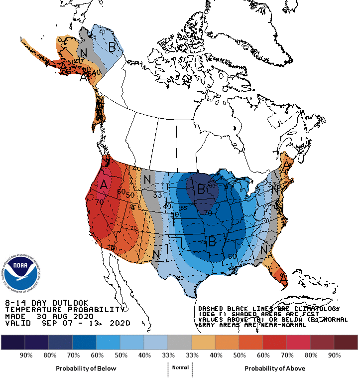
It looks like we’ll have several cool days after that. The NWS Climate Prediction Center shows a strong tendency for cooler than normal temperatures in Minnesota and Wisconsin from September 7 through September 13:
Meteorological summer is winding down
Many meteorologists refer to our three warmest months (June, July and August) as summer. Monday will be our final day of meteorological summer. If you prefer astronomical signposts for the seasons, astronomical summer ends on September 22 this year.
Programming note
You can hear my live weather updates on MPR News at 7:35 a.m., 9:35 a.m. and 4:35 p.m. each Saturday and Sunday.

