
Monday starts off soggy
Temperatures cool behind a cold front
Go Deeper.
Create an account or log in to save stories.
Like this?
Thanks for liking this story! We have added it to a list of your favorite stories.


Nonsevere showers and storms moving across Minnesota give way to sunshine by afternoon.
Monday’s forecast
A cold front making its way through the state is bringing showers and storms with it Monday morning. The front is already pushing into eastern Minnesota as of 7 a.m., with the western edge of the state now out of the rain.
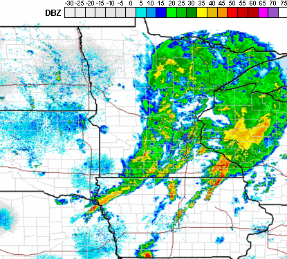
As the front clears out of the state, the precipitation will continue to clear west to east. Most of the wet weather moves out by midday, replaced by sunshine as the system exits.
In addition to the rain, the front is also ushering in cooler temperatures. Monday morning is starting fairly seasonable, with much of the state in the 50s. By afternoon however, most highs will run 5 to 10 degrees below average, with 60s in northern Minnesota and 70s south.

After Monday’s rain, the week ahead stays predominantly sunny, with only minor precipitation chances.
That extended forecast will be updated around 9 a.m.
Programming note
You can hear my live weather updates on Minnesota Public Radio at 7:48 a.m. Monday through Friday morning.
Turn Up Your Support
MPR News helps you turn down the noise and build shared understanding. Turn up your support for this public resource and keep trusted journalism accessible to all.

