
A summery Sunday as winds pick up
Dew points in the sticky 60s
Go Deeper.
Create an account or log in to save stories.
Like this?
Thanks for liking this story! We have added it to a list of your favorite stories.


I imagine that some people are a bit sleepy this morning, due to the thunderstorms that woke them up overnight. There were several reports of large hail Saturday night, including this one from Olivia:
Additional hail reports can be found here.
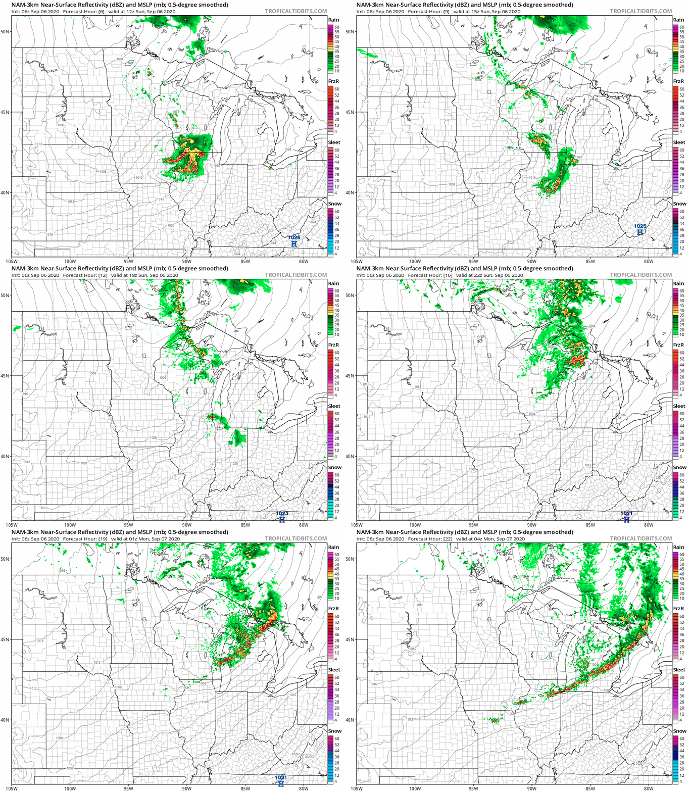
Thunderstorms are possible in far southeastern Minnesota early this morning, then most of Minnesota will have a rain-free day. There will be a chance of scattered showers and an isolated thunderstorm today in parts of northeastern Minnesota and western Wisconsin.
The National Oceanic and Atmospheric Administration’s North American Mesoscale (NAM) forecast model shows the potential rain pattern this Sunday and Sunday evening:
Turn Up Your Support
MPR News helps you turn down the noise and build shared understanding. Turn up your support for this public resource and keep trusted journalism accessible to all.
Summery but windy
Sunday highs reach the 80s in the southern half of Minnesota plus most of western Wisconsin:
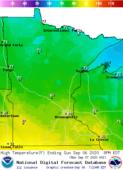
Northern Minnesota will have highs in the 70s.
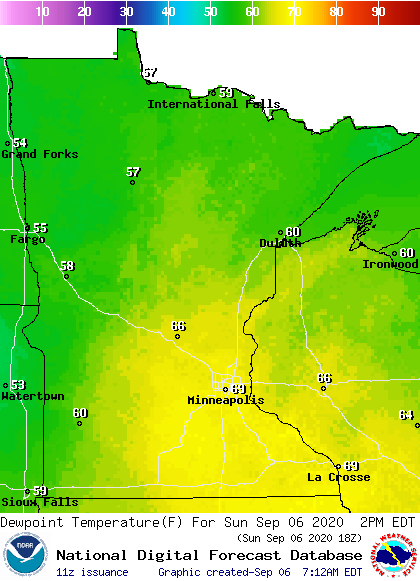
Dew points will be in the sticky 60s in the warmest areas:
Winds will gust to 20-30 mph in the Twin Cities this afternoon, with gusts over 40 mph in northwestern Minnesota:
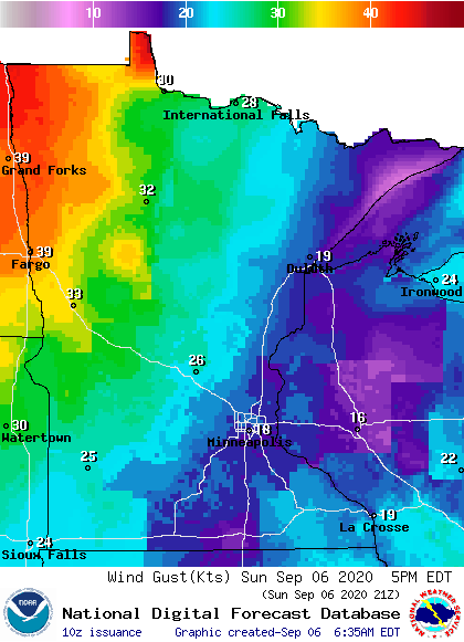
Plotted winds are in knots, with 18 knots equal to 21 mph and 39 knots equal to about 45 mph.
A wind advisory runs from 1 p.m. to 8.pm. today in northwestern Minnesota:

Details of the wind advisory:
URGENT - WEATHER MESSAGE National Weather Service Grand Forks ND 332 AM CDT Sun Sep 6 2020 MNZ002-003-005-006-008-013>015-NDZ039-070100- /O.NEW.KFGF.WI.Y.0014.200906T1800Z-200907T0100Z/ Norman-Clay-Roseau-Lake Of The Woods-East Marshall-Pennington- Red Lake-East Polk-Cass- Including the cities of Ada, Twin Valley, Halstad, Moorhead, Roseau, Warroad, Greenbush, Baudette, Newfolden, Middle River, Grygla, Thief River Falls, Red Lake Falls, Fosston, Fertile, McIntosh, Erskine, and Fargo 332 AM CDT Sun Sep 6 2020 ...WIND ADVISORY IN EFFECT FROM 1 PM THIS AFTERNOON TO 8 PM CDT THIS EVENING... * WHAT...Northwest winds 25 to 35 mph with gusts up to 45 mph expected. * WHERE...In Minnesota, Norman, Clay, Roseau, Lake Of The Woods, East Marshall, Pennington, Red Lake and East Polk Counties. In North Dakota, Cass County. * WHEN...From 1 PM this afternoon to 8 PM CDT this evening. * IMPACTS...Gusty winds will blow around unsecured objects. Travel will be difficult especially for high profile vehicles. PRECAUTIONARY/PREPAREDNESS ACTIONS... Use extra caution when driving, especially if operating a high profile vehicle. Secure outdoor objects.
Gale warnings for Lake Superior begin at 9 p.m. Sunday:
URGENT - MARINE WEATHER MESSAGE National Weather Service Marquette MI 418 AM EDT Sun Sep 6 2020 LSZ162-061630- /O.EXB.KMQT.GL.W.0035.200907T0200Z-200907T1200Z/ /O.UPG.KMQT.GL.A.0017.200907T0400Z-200907T1200Z/ Lake Superior west of a line from Saxon Harbor WI to Grand Portage MN beyond 5NM- 418 AM EDT Sun Sep 6 2020 /318 AM CDT Sun Sep 6 2020/ ...GALE WARNING IN EFFECT FROM 10 PM EDT /9 PM CDT/ THIS EVENING TO 8 AM EDT /7 AM CDT/ MONDAY... * WHAT...Northwest winds 20 to 30 kt with gusts up to 40 kt and waves 4 to 7 feet expected. * WHERE...Lake Superior west of a line from Saxon Harbor WI to Grand Portage MN beyond 5NM. * WHEN...From 10 PM EDT /9 PM CDT/ this evening to 8 AM EDT /7 AM CDT/ Monday. * IMPACTS...Strong winds will cause hazardous waves which could capsize or damage vessels and reduce visibility. PRECAUTIONARY/PREPAREDNESS ACTIONS... Mariners should alter plans to avoid these hazardous conditions. Remain in port, seek safe harbor, alter course, and/or secure the vessel for severe conditions.
You can hear updated weather information on the MPR network, and you’ll see updated weather info on the MPR News live weather blog.
This Updraft blog will be updated by around 10 a.m., with details on the rest of this Labor Day weekend and a look at the chilly temps that are on tap this coming week.
Programming note
You can hear my live weather updates on MPR News at 7:35 a.m., 9:35 a.m. and 4:35 p.m. each Saturday and Sunday.

