
Freeze concerns as temperatures drop
Predominantly dry and mostly sunny into next week
Go Deeper.
Create an account or log in to save stories.
Like this?
Thanks for liking this story! We have added it to a list of your favorite stories.


A cold front is dropping Minnesota back below average through late week, but skies stay mostly sunny and next week turns mild.
Wednesday’s Forecast
A cold front that has been slowly moving across the state since Tuesday, finally cleared through Minnesota Wednesday morning.
Behind it, a breezy northwest wind is drawing colder air across the state.
Wednesday morning started seasonably, with a few lows in the 40s north, and most of the state in the 50s. Highs however, will be about 10 degrees cooler than Tuesday, ranging from 50s north to a few 70s south.
Turn Up Your Support
MPR News helps you turn down the noise and build shared understanding. Turn up your support for this public resource and keep trusted journalism accessible to all.

High pressure settles in behind the cold front, bringing mostly sunny skies by afternoon, including to northern Minnesota which sees a few more clouds through the morning.
Colder then mild
Under mostly clear skies, combined with the colder air, much of northern Minnesota will drop to near or below freezing overnight Wednesday, and parts of the Arrowhead could dip into the 20s.
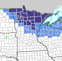
Because of this all of northern and portions of central Minnesota are under either freeze warnings (purple) or frost advisories (blue) from midnight until 8 a.m. Thursday morning.
Frost and freeze areas are also likely Friday morning in northern Minnesota.
For highs, the entire state only gets into the 50s and 60s Thursday and Friday, which is at least 10 degrees below average for most of Minnesota.
Temperatures slowly warm closer to average as we head toward the weekend.
Here is that temperature trend for the Twin Cities:
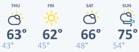
By next week, temperatures turn warmer again, with highs in the 60s and 70s north, and 70s and possible 80s south.
Dry skies
Under the influence of high pressure, dry and mostly sunny skies prevail through Saturday. However, patchy fog is likely Thursday and Friday morning. A few spotty showers are possible Sunday into Monday, but overall next week also stays predominantly dry.
While that keeps skies mostly sunny, it is not good news for the portions of Minnesota that are seeing a drier than average year, including the Arrowhead and southwestern Minnesota.
In fact, Duluth has been so dry, that to-date it is having its fifth driest year on record.

Programming note
You can hear my live weather updates on Minnesota Public Radio at 7:48 a.m. Monday through Friday morning.

