
Frost and freeze concerns, plus a chance for snow
Wednesday stays windy with more rain, then temperatures drop
Go Deeper.
Create an account or log in to save stories.
Like this?
Thanks for liking this story! We have added it to a list of your favorite stories.


The weather Wednesday stays windy with more rain chances, but temperatures remain seasonable. Then much colder air moves across Minnesota as we approach the weekend.
Wednesday’s forecast
All of Minnesota started off above average Wednesday, with 40s for most of the state and 50s south.
Due to a cold front that cleared through southern Minnesota early Wednesday, temperatures rise little through the day, with forecast highs in the 50s and 60s.

This is seasonable for late September, but slightly cooler than Tuesday.
Turn Up Your Support
MPR News helps you turn down the noise and build shared understanding. Turn up your support for this public resource and keep trusted journalism accessible to all.
The scattered showers parts of Minnesota saw overnight and early Wednesday have cleared, but now another cold front is already approaching northern Minnesota that will start brining scattered showers and isolated storms north, and spottier activity south. That includes occasional showers and storms for the Twin Cities from Wednesday afternoon into early Thursday.
Here is the weather pattern, with Minnesota between the influence of the two cold fronts:

With that pattern, winds have already increased, and gusts will top 30 and even 40 mph for portions of western and southern Minnesota.
Cold weather returns
Colder air is already funneling across Minnesota behind the front that pushed through Wednesday morning. The second cold front moves through the state by mid-Thursday, with much colder air on the way.
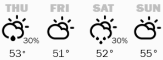
By Thursday, and through the weekend, highs drop into only the 40s and 50s, putting much of the state 10 to 15 degrees below average.
Here is that forecast trend for the Twin Cities through Sunday:
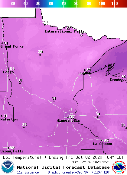
Meanwhile, overnight lows turn cold enough to cause widespread front and freeze concerns across the entire state, particularly Friday morning, when temperatures will only be in the 20s north and 30s south.
More rain and a chance for snow
The rain from Wednesday lingers overnight and clears for all but possibly southeastern Minnesota by Thursday morning. Then the state gets a brief drier break and even a bit more sunshine Thursday afternoon and Friday morning. Friday afternoon more clouds move back in, ahead of another round of precipitation that moves in overnight Friday and brings light rain chances to much of the state Saturday.
However, because of the colder weather, there is a possibility that early Saturday morning, a few flakes of snow could mix in for northern Minnesota.
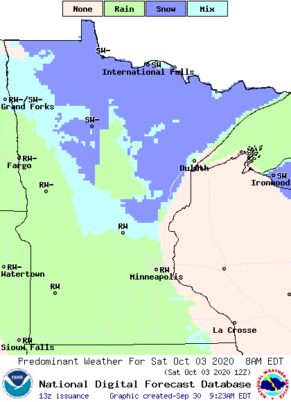
If that happens, it would be our first snow of the season, and slightly earlier than average for that milestone!
Programming note
You can hear my live weather updates on Minnesota Public Radio at 7:48 a.m. Monday through Friday morning.

