
Weekend forecast: Chilly, with a Saturday shower chance
Frost advisory includes metro area late Thursday night/early Friday
Go Deeper.
Create an account or log in to save stories.
Like this?
Thanks for liking this story! We have added it to a list of your favorite stories.


I’ll get to the weekend forecast shortly, but first we have to talk about frost and freezing temps tonight into Friday morning.
Low temperatures Thursday night into early Friday are expected to reach the 20s across most of the northern half of Minnesota as well as western Wisconsin. The Twin Cities metro area and much of the southern half of Minnesota will dip into the low and middle 30s. Winds will be light by Friday morning, so plants near the ground will experience temps that are a few degrees cooler than the official temps that are recorded five feet above the ground.
Here’s a map of frost advisories and freeze warnings for late Thursday night into early Friday:

Areas without warnings or advisories have already seen the end to their 2020 growing season.
Turn Up Your Support
MPR News helps you turn down the noise and build shared understanding. Turn up your support for this public resource and keep trusted journalism accessible to all.
Here are details of the frost advisory that includes most of the Twin Cities metro area from 1 a.m. to 8 a.m. on Friday:
URGENT - WEATHER MESSAGE National Weather Service Twin Cities/Chanhassen MN 1111 AM CDT Thu Oct 1 2020 MNZ054-060-062>064-068>070-073>078-082>085-091>093-020015- /O.CON.KMPX.FR.Y.0005.201002T0600Z-201002T1300Z/ Lac Qui Parle-Hennepin-Ramsey-Washington-Yellow Medicine-Carver- Scott-Dakota-Redwood-Brown-Nicollet-Le Sueur-Rice-Goodhue- Watonwan-Blue Earth-Waseca-Steele-Martin-Faribault-Freeborn- Including the cities of Madison, Minneapolis, St Paul, Stillwater, Granite Falls, Chanhassen, Chaska, Victoria, Shakopee, Hastings, Redwood Falls, New Ulm, St Peter, Le Sueur, Faribault, Red Wing, St James, Mankato, Waseca, Owatonna, Fairmont, Blue Earth, and Albert Lea 1111 AM CDT Thu Oct 1 2020 ...FROST ADVISORY REMAINS IN EFFECT FROM 1 AM TO 8 AM CDT FRIDAY... * WHAT...Temperatures as low as 33 will result in frost formation. * WHERE...Portions of east central, south central, southeast, southwest and west central Minnesota. * WHEN...From 1 AM to 8 AM CDT Friday. * IMPACTS...Frost could kill sensitive outdoor vegetation if left uncovered. PRECAUTIONARY/PREPAREDNESS ACTIONS... Take steps now to protect tender plants from the cold.
People who want to preserve sensitive outdoor plants could cover them Thursday evening and small potted plants could be brought indoors.
Chilly weekend
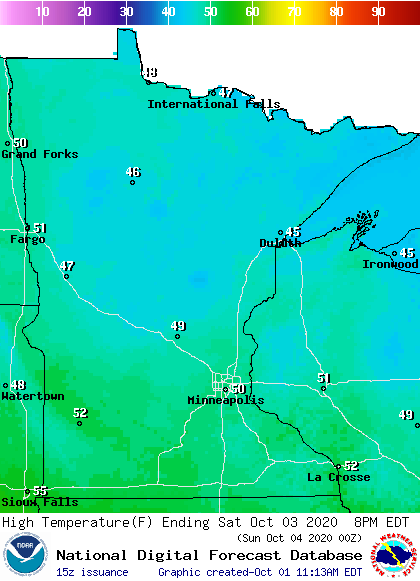
Our average Twin Cities high temperature is 64 degrees on Oct. 3. We’ll top out at a chilly 50 degrees in the metro area this Saturday. Northern and central Minnesota can expect Saturday highs in the 40s, with some lower 50s in far southern Minnesota:
At least we’ll have light winds his weekend!
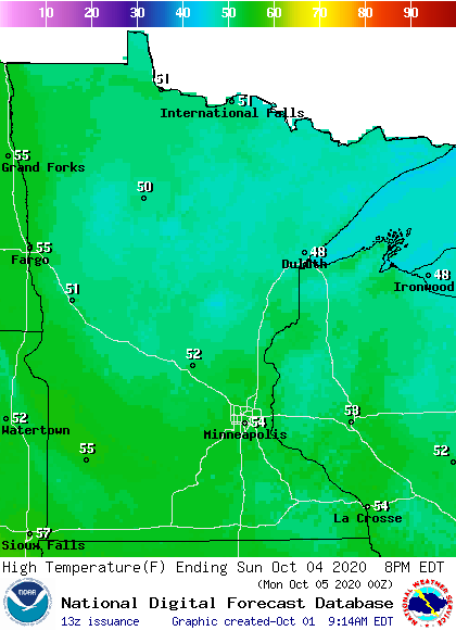
Sunday highs will be mainly in the 50s, with some 40s in northeastern Minnesota:
Saturday shower chances
The best chance of showers this weekend will be in western and southern Minnesota plus parts of western Wisconsin. Far northern Minnesota could see a few snowflakes mixed with patchy rain showers on Saturday.
The National Oceanic and Atmospheric Administration’s North American Mesoscale (NAM) forecast model shows the potential rain pattern Friday evening through Saturday afternoon:
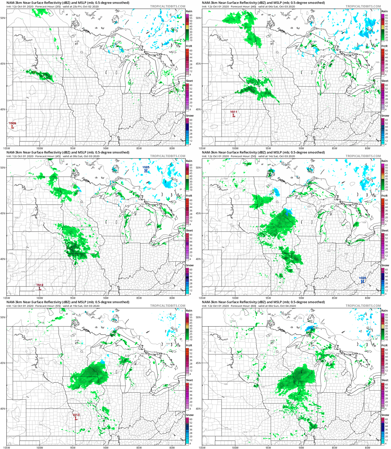
Sunday look rain-free at this point.
Fall colors
We’re seeing some great fall colors in parts of Minnesota right now. Here’s the latest fall color report from the Minnesota Department of Natural Resources:

Keep in mind that all deciduous trees are included in the fall color report, not just maples.
The Wisconsin fall color report can be found here.
Programming note
You can hear my live weather updates on MPR News at 7:35 a.m., 9:35 a.m. and 4:39 p.m. each Saturday and Sunday.

