
Frosty start on Sunday; temps rebound this coming week
50th anniversary for NWS and NOAA
Go Deeper.
Create an account or log in to save stories.
Like this?
Thanks for liking this story! We have added it to a list of your favorite stories.


Let’s start with a shout out to the National Oceanic and Atmospheric Administration (NOAA), which was established 50 years ago today! NOAA is the parent organization of the National Weather Service, which replaced the Weather Bureau 50 years ago:
The National Weather Service mission began 150 years ago under the U.S. Army Signal Service:
The NWS office in Chanhassen, Minn., issues forecasts and weather warnings/advisories for the Twin Cities metro area and portions of central Minnesota and west-central Wisconsin as well as south-central Minnesota.
Chilly Sunday
Turn Up Your Support
MPR News helps you turn down the noise and build shared understanding. Turn up your support for this public resource and keep trusted journalism accessible to all.
After clouds break up late Saturday night, temperatures will drop into the 30s in many areas, with some 20s in far northern Minnesota and northwestern Wisconsin. Anyone who’s been covering their plants to protect them from our chilly overnight temps will want to do that again Saturday night.
The NWS has issued a frost advisory from 3 a.m. to 9 a.m. Sunday that includes Twin Cities metro area and most of the southern half of Minnesota plus west-central and southwestern Wisconsin:

The growing season has already ended in areas to the north that are not in the frost advisory.
You can hear updated weather information on the MPR network, and you’ll see updated weather info on the MPR News live weather blog.
Temperature trends
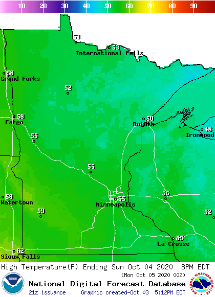
Our Saturday high of 52 degrees at Minneapolis-St. Paul International Airport was well below our average Twin Cities Oct. 3 high temp of 64 degrees. We’re shooting for a high in the mid 50s in the metro area on Sunday.
Sunday highs will reach the 50s in most areas, and they could approach 60 degrees in far southwestern Minnesota:
Winds will be gusty in northwestern Minnesota Sunday afternoon.
Monday highs will be mainly in the 60s, with 70s in west-central and southwestern Minnesota:
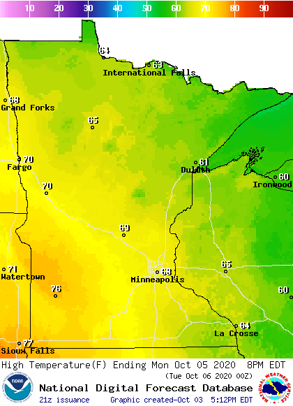
Twin Cities metro area highs are projected to reach the upper 60s on Monday, then around 70 Tuesday, followed by mid 60s Wednesday and Thursday and lower 70s on Friday.
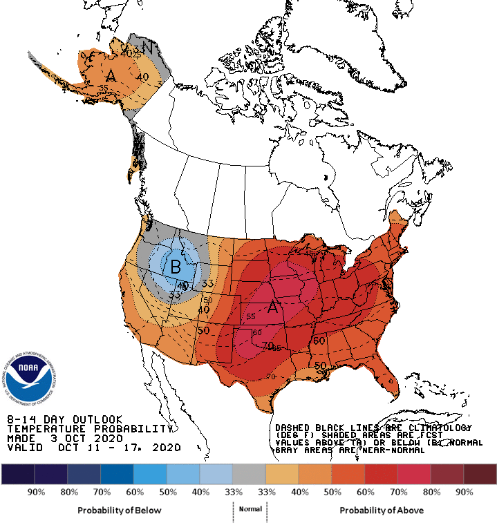
Warmer than normal temps may linger next weekend and into the following week. The NWS Climate Prediction Center shows a strong tendency for above-normal temps in Minnesota and Wisconsin from Oct. 11 through Oct. 17:
Fall colors
We’re seeing some vibrant fall colors across much of Minnesota right now. Here’s the latest fall color report from the Minnesota Department of Natural Resources:
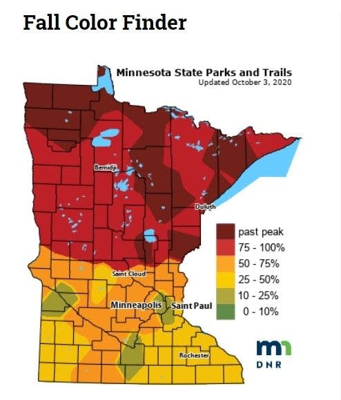
Keep in mind that all deciduous trees are included in the fall color report, not just maples.
The Wisconsin fall color report can be found here.
Programming note
You can hear my live weather updates on MPR News at 7:35 a.m., 9:35 a.m. and 4:39 p.m. each Saturday and Sunday.

