
Significant October warmth continues
Rain chances remain slim until next week
Go Deeper.
Create an account or log in to save stories.
Like this?
Thanks for liking this story! We have added it to a list of your favorite stories.


The trend of warm and drier weather persists through the weekend, including another chance at 80s for southern Minnesota.
A number of places in southern Minnesota saw 80s Tuesday, including the Twin Cities, a milestone the metro area doesn’t always hit in October.
In fact, the last time the Twin Cities saw 80s in October was back in 2015, and for 2019, the highest October temperature was only 73 degrees.
Now, the Twin Cities (along with much of southern Minnesota) could see 80s in October a second time later this week, highlighting how impressive the current warm trend is.
Turn Up Your Support
MPR News helps you turn down the noise and build shared understanding. Turn up your support for this public resource and keep trusted journalism accessible to all.
Wednesday’s forecast
Despite a cold front that moved through Minnesota late Tuesday, morning temperatures were above average Wednesday with mostly 40s north and 50s south.
The cooler air behind the front drops afternoon highs about 10 degrees from the warm weather on Tuesday, but temperatures ranging from 50s north to 70s south are still at or above average for Oct. 7.
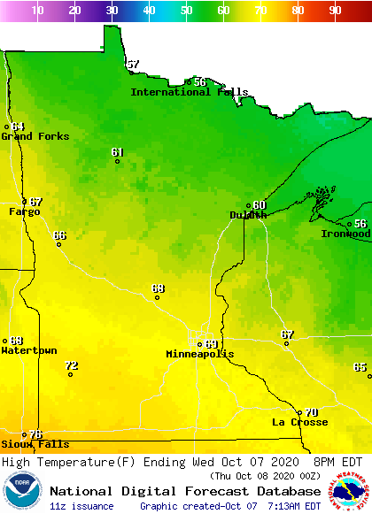
Most of the state sees sunny skies and lighter winds Wednesday. The one exception is northern Minnesota, where a disturbance that clips near the border brings breezier conditions, a few more clouds, and a very light rain chance.
Dry and mild weather continues
Thursday will be very similar to Wednesday, with most of the state in the 60s and widespread sunshine.
By Friday afternoon, warm winds out of the south and more sunshine send temperatures soaring back into the 70s and 80s. Although not as warm as Friday, the weekend also remains above average, with highs predominantly in the 60s and 70s.
Here is that forecast for the Twin Cities, showing the big warm-up Friday:
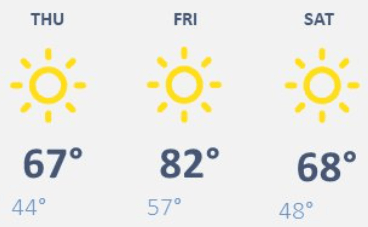
Mostly sunny skies continue until Sunday, when a few more clouds start moving in, along with rain late in the day.
Colder weather returns next week
The rain chance Sunday is ahead of a weather system that is currently forecast to pass through Minnesota on Monday.
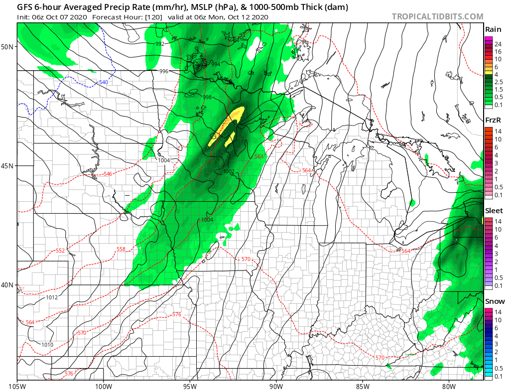
This will bring needed rain across much of the sate on Monday, with some lingering showers possible Tuesday.
While the precipitation forecast is still somewhat uncertain, it looks like many parts of the state could see at least one-half inch of rain, which would be very beneficial given the stretch of drier weather Minnesota has seen since September.
That storm also ends the warm trend, dropping highs back to more seasonable temperatures in the 50s and 60s by the middle of next week.
Programming note
You can hear my live weather updates on Minnesota Public Radio at 7:48 a.m. Monday through Friday morning.

