
Windy today; thunderstorms at times Sunday evening
Fall color update for leaf-peepers
Go Deeper.
Create an account or log in to save stories.
Like this?
Thanks for liking this story! We have added it to a list of your favorite stories.


I glaced outside this morning and saw some colorful leaves passing by my window. Gusty winds will cause “leaf showers” at times today.
If leaf-peeping is in your Sunday plans, it’s good to know that we still have some gorgeous fall color in parts of Minnesota. Here’s the latest fall color report from the Minnesota Department of Natural Resources:
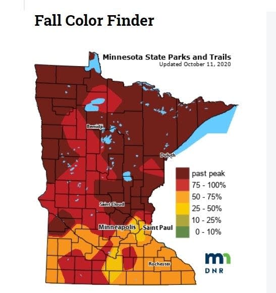
Keep in mind that all deciduous trees are included in the fall color report, not just maples.
The Wisconsin fall color report can be found here.
Turn Up Your Support
MPR News helps you turn down the noise and build shared understanding. Turn up your support for this public resource and keep trusted journalism accessible to all.
Windy afternoon/evening
Western Minnesota could see wind gusts of 35-45 mph Sunday afternoon/evening, with 25-30 mph gusts in eastern Minnesota and western Wisconsin. Higher gusts can be expected near any thunderstorms that develop.
Thunderstorm chances
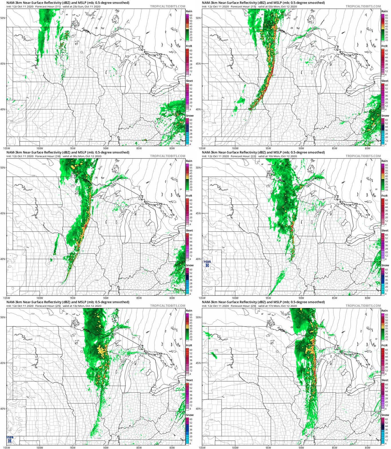
Areas of rain and embedded thunderstorms are expected to develop in parts of western Minnesota by late Sunday afternoon. The rain/embedded t-storms will spread into eastern Minnesota and western Wisconsin as we go through Sunday evening and Sunday night. Many areas are expected to see a half-inch to one inch of rain Sunday evening through Sunday night.
The National Oceanic and Atmospheric Administration’s North American Mesoscale (NAM) forecast model shows the potential rain pattern Sunday evening through Monday morning:
Severe weather chances
The NWS Storm Prediction Center shows a slight risk of severe weather late Sunday afternoon and into Sunday evening and Sunday night for much of west-central, southwestern and south-central Minnesota and also Carver, Scott and Dakota counties of the Twin Cities metro area:
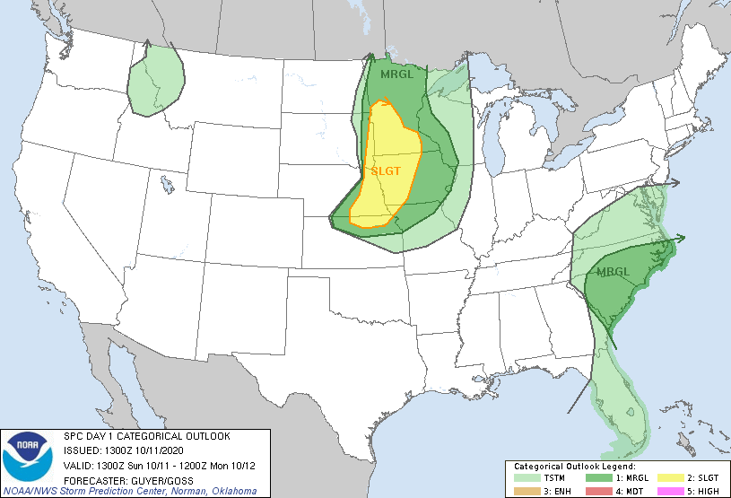
Slight risk (shaded yellow) means that scattered severe t-storms are possible. It still looks like t-storms should hold off until after sunset in Twin Cities metro area, with our best chance of t-storms in the metro area from around 8 p.m. or 9 p.m. to about midnight. SPC shows a marginal risk (shaded dark-green) of severe weather Sunday evening/Sunday night elsewhere in Minnesota and into western Wisconsin. Marginal risk means that an isolated severe thunderstorm is possible.
______________________________________________________________________________________
Midday update
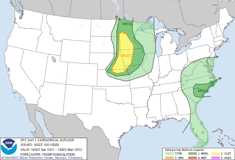
The updated severe weather outlook from the NWS Storm Prediction Center keeps Carver and Scott counties of the Twin Cities metro area in the slight risk category for severe weather Sunday evening/night, but Dakota County is now in a marginal risk of severe weather for that time period:
____________________________________________________________________________________________
You can hear updated weather information on the MPR network, and you’ll see updated weather info on the MPR News live weather blog.
How dry has it been?
It’s great to see some rain in the forecast for Sunday evening and Sunday night. Only two-hundredths of an inch of rain has been tallied so far this month at Minneapolis-St. Paul International Airport. Our September rainfall was 2.20 inches below normal at MSP airport. When you combine September and the first 10 days of October, our official Twin Cities rainfall is running 3.10 inches below normal.
Monday details
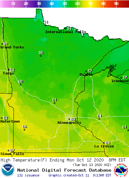
Monday highs will be in the 50s north, with 60s in central and southern Minnesota:
Monday won’t be as windy as Sunday, but Monday afternoon gusts will still be in the 16-26 mph range:
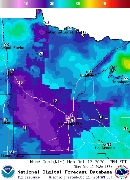
Plotted values are in knots, with 15 knots equal to around 17 mph and 21 knots equal to around 24 mph.
The rest of this week:
Twin Cities metro area highs are projected to reach the lower 60s Tuesday and Wednesday, then it gets colder High in the lower 50s are on tap for Thursday and we might only reach 50 on Friday.
Programming note
You can hear my live weather updates on MPR News at 7:35 a.m., 9:35 a.m. and 4:39 p.m. each Saturday and Sunday.

