Saturday snow in northern Minnesota; sprinkle chance in the south

Cooler temps on Sunday
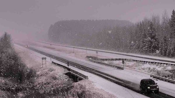
An early-season snowfall coats a stretch of U.S. Highway 53
An early-season snowfall coats a stretch of U.S. Highway 53 near Cotton, Minn., on Saturday, Oct. 17, 2020.
Minnesota Department of Transportation

Snow will continue to accumulate in much of the northern third of Minnesota Saturday afternoon, and several inches are possible in some locations.

The National Oceanic and Atmospheric Administration’s North American Mesoscale (NAM) forecast model shows the potential precipitation pattern this Saturday afternoon through Saturday evening:

rt1017rad2
Simulated radar Saturday afternoon and evening
NOAA, via Tropicaltidbits.com

A few areas of rain showers could develop over southern Minnesota and west-central Wisconsin Saturday afternoon. The Twin Cities metro area could see a passing rain shower at some point.

Snow amounts

Create a More Connected Minnesota

MPR News is your trusted resource for the news you need. With your support, MPR News brings accessible, courageous journalism and authentic conversation to everyone - free of paywalls and barriers. Your gift makes a difference.

Here are forecast snow amounts, from the Duluth office of the NWS:

rt1017dlhsnow2
Saturday forecast snow totals
National Weather Service

The Grand Forks NWS office posted these forecast snow amounts in northwestern Minnesota and eastern North Dakota:

rt1017gfksnow
Saturday snow forecast
National Weather Service

Winter weather advisories are in effect until mid-afternoon in parts of northwestern Minnesota and eastern North Dakota:

rt1017gfkadv4
Saturday winter weather advisories
National Weather Service

The winter weather advisories continue right into Saturday evening in northeastern Minnesota:

rt1017dlhadv4
Saturday winter weather advisories
National Weather Service

Here are details of the winter weather advisory in northeastern Minnesota, which includes Duluth:

URGENT - WINTER WEATHER MESSAGE National Weather Service Duluth MN 958 AM CDT Sat Oct 17 2020 ...FIRST ACCUMULATING SNOW OF THE SEASON... .A fall storm will bring the first accumulating snow of the season. Locally higher accumulations may be possible in the higher elevations of the North Shore and areas from the Brainerd Lakes region to central and southern St. Louis County. MNZ011-019-037-180300- /O.CON.KDLH.WW.Y.0015.000000T0000Z-201018T0300Z/ North St. Louis-Central St. Louis-Carlton and South St. Louis- Including the cities of Ely, Hibbing, and Duluth 958 AM CDT Sat Oct 17 2020 ...WINTER WEATHER ADVISORY REMAINS IN EFFECT UNTIL 10 PM CDT THIS EVENING... * WHAT...Snow. Additional snow accumulations of 1 to 3 inches. * WHERE...Central St. Louis, North St. Louis and Carlton and South St. Louis Counties. This includes the Tribal Lands of the Fond du Lac Band and the Bois Forte Band, Nett Lake and, Lake Vermillion areas. * WHEN...Until 10 PM CDT this evening. * IMPACTS...Plan on slippery road conditions. PRECAUTIONARY/PREPAREDNESS ACTIONS... Slow down and use caution while traveling. The latest road conditions can be obtained by calling 5 1 1. Road conditions can also be found at 511mn.org for Minnesota or 511wi.gov for Wisconsin.

You can hear updated weather information on the MPR network, and you’ll see updated weather info on the MPR News live weather blog.

Weekend temps and winds

Our average Twin Cities high temp is 58 degrees on Oct. 17. The metro area could see highs in the low to mid-50s this Saturday, with falling temps by late afternoon.

Highs will probably range from the mid and upper 30s in northeastern Minnesota to the upper 50s in far southern Minnesota Saturday afternoon.

Sunday highs will be chilly, with 30s in many areas and some lower 40s in the Twin Cities and southern Minnesota:

rt1018h3
Sunday forecast highs
National Weather Service

Sunday will be breezy, with gusts of 16 to 24 mph:

rt1018g3
Sunday forecast wind gusts
National Weather Service

Plotted values are in knots, with 14 knots equal to around 16 mph. Gusts over 25 mph are possible Sunday afternoon in northwestern Minnesota

Fall colors

Strong winds pulled a lot of leaves off of our trees this week. Spotty fall colors remain on trees that were slower to change over from green to yellow, orange and red.

Here’s the latest fall color report from the Minnesota Department of Natural Resources:

rt1017fall
Fall colors Friday
Minnesota Department of Natural Resources

Portions of the Twin Cities metro area and parts of far southern Minnesota haven’t reached “past peak” fall color status yet.

Keep in mind that all deciduous trees are included in the fall color report, not just maples.

The Wisconsin fall color report can be found here.

Temperature trends

Twin Cities metro area highs are projected to reach the lower 40s Monday, followed by mid 40s Tuesday, upper 40s Wednesday and Thursday and then back to the mid 40s Friday.

It looks like chilly temps will linger into next weekend and into the following week. The NWS Climate Prediction Center temperature outlook for Oct. 24 through Oct. 30 shows a strong tendency for below-normal temperatures in Minnesota and Wisconsin:

rt1017exten
Temperature outlook Oct. 24 through Oct. 30
NWS Climate Prediction Center

We’ll see if that pans out.

Programming note

You can hear my live weather updates on MPR News at 7:35 a.m., 9:35 a.m. and 4:39 p.m. each Saturday and Sunday.