
Minnesota stays cold Monday
The southern edge of the state sees light showers
Go Deeper.
Create an account or log in to save stories.
Like this?
Thanks for liking this story! We have added it to a list of your favorite stories.


Monday remains much colder than average, and a disturbance brings light rain and snow across southern Minnesota.
Monday’s forecast
The state is starting Monday chilly, with temperatures mostly in the 20s, and highs will be about 10 to 20 degrees below average with most of the state in the 30s.

For perspective, the average Twin Cities high and low for Oct. 19 are 57 and 39, meaning the high Monday will be closer to our average low.
Fortunately, winds stay relatively light, so wind chill is not much of a factor.
Turn Up Your Support
MPR News helps you turn down the noise and build shared understanding. Turn up your support for this public resource and keep trusted journalism accessible to all.
Northern Minnesota stays dry Monday, with partly sunny skies.
Because of a disturbance moving across southern Minnesota, the southern half of the state stays cloudier and will see some light rain and snow move through.
There are already a couple flurries in southwestern Minnesota as of 7 a.m.
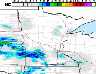
For the Twin Cities, the most likely timing is a few sprinkles and flurries late morning through the afternoon.
A much more potent snowstorm targets Minnesota with widespread accumulation Tuesday.
That extended forecast will be updated around 9 a.m.
Programming note
You can hear my live weather updates on Minnesota Public Radio at 7:48 a.m. Monday through Friday morning.

