
Saturday night/Sunday snow heaviest in southern Minnesota
Go Deeper.
Create an account or log in to save stories.
Like this?
Thanks for liking this story! We have added it to a list of your favorite stories.


I’ll start with a look at how unusual it is to see this much snow in October.
The light snow Friday morning pushed our Twin Cities October 2020 snowfall total to a record 8.9 inches:
According to the Duluth NWS office, a new October snowfall record has also been set in Brainerd, with 10.1 inches. The 12 inches of snow this month in Duluth makes this the second-snowiest October there, trailing only the 14 inch total of October 1933.
More snow
Turn Up Your Support
MPR News helps you turn down the noise and build shared understanding. Turn up your support for this public resource and keep trusted journalism accessible to all.
Parts of northeastern Minnesota and portions of west-central and southwestern Minnesota may see some light snow showers or flurries this Saturday afternoon. As we go through Saturday evening and the overnight hours, accumulating snow is expected to spread over roughly the southern third of Minnesota and into western Wisconsin. Periods of snow will linger in those same areas through Sunday. Flurries or patchy light snow showers are possible on Sunday in central Minnesota.
The National Oceanic and Atmospheric Administration’s North American Mesoscale (NAM) forecast model shows the potential precipitation pattern Saturday evening through Sunday evening:

How much snow?
The Twin Cities metro area could see a half-inch to one inch of snow overnight Saturday night, with another half-inch to one inch possible on Sunday. The far north metro may only see a dusting of snow.
The highest snow totals Saturday evening through Sunday are expected in southwestern and south-central Minnesota, with 3 to 4 inches and some spotty 5 inch totals possible:

A winter weather advisory begins in southwestern Minnesota at 7 pm today and it’ll continue through Sunday evening.
Here are details of the advisory:
URGENT - WINTER WEATHER MESSAGE National Weather Service Sioux Falls SD 254 AM CDT Sat Oct 24 2020 IAZ001-002-MNZ072-080-081-089-090-097-098-SDZ061-062-066>069- 241700- /O.CON.KFSD.WW.Y.0021.201025T0000Z-201026T0600Z/ Lyon-Osceola-Murray-Cottonwood-Nobles-Jackson-Pipestone-Rock- McCook-Minnehaha-Turner-Lincoln-Bon Homme-Yankton- 254 AM CDT Sat Oct 24 2020 ...WINTER WEATHER ADVISORY REMAINS IN EFFECT FROM 7 PM THIS EVENING TO 1 AM CDT MONDAY... * WHAT...Snow expected. Total snow accumulations of 2 to 5 inches. * WHERE...Portions of southeast South Dakota, northwest Iowa and southwest Minnesota. * WHEN...From 7 PM this evening to 1 AM CDT Monday. * IMPACTS...Plan on slippery road conditions and reduced visibility. PRECAUTIONARY/PREPAREDNESS ACTIONS... Slow down and use caution while traveling. The latest road conditions for the state you are calling from can be obtained by calling 5 1 1.
You can hear updated weather information on the MPR network, and you’ll see updated weather info on the MPR News live weather blog.
Cold temps this weekend
Our average Twin Cities high temp is 54 degrees on Oct. 24. The metro area will probably top out in the lower 30s this Saturday. Highs will range from the upper 20s to lower 30s across most of Minnesota and western Wisconsin this weekend.
Here’s a look at Sunday forecast highs:

To put these weekend temps in perspective, 32 degrees is our average Twin Cities high temp on Dec. 1.
Any warmth in sight?
Twin Cities metro area highs are projected to be around 30 Monday, followed by lower 30s Tuesday, upper 30s Wednesday, around 40 Thursday and in the middle 40s on Friday. We may top out in the upper 40s on Halloween.
The NWS Climate Prediction Center isn’t showing a strong signal toward warm or cool temps from Oct. 31 through Nov. 6:
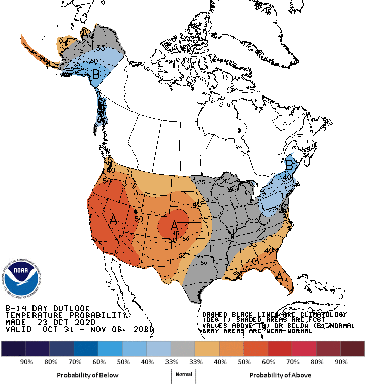
The outlook shows just a slight tendency for above-normal temps in southwestern Minnesota. I wouldn’t mind seeing near-normal temps during the first week of November!
Programming note
You can hear my live weather updates on MPR News at 7:35 a.m., 9:35 a.m. and 4:39 p.m. each Saturday and Sunday.

