
A chilly start to the week; milder temps by midweek
50s by next weekend?
Go Deeper.
Create an account or log in to save stories.
Like this?
Thanks for liking this story! We have added it to a list of your favorite stories.


We didn’t see huge amounts of snow Saturday night and Sunday, but it was enough to make many roads slick. The Minnesota State Patrol reported 173 crashes in Minnesota on Sunday, with 30 injuries:

Thankfully, no serious injuries or fatalities were reported.
Snow amounts
Many weather observers take their snow measurements in the early evening hours, so the Sunday snow totals aren’t all in yet. I did see a Sunday afternoon report of 2.5 inches of new snow in Mankato.
Turn Up Your Support
MPR News helps you turn down the noise and build shared understanding. Turn up your support for this public resource and keep trusted journalism accessible to all.
You can see new snow reports as they are updated by the NWS here. Hover over any snow report on the NWS map for details on the snow amount, plus the exact location and time of the snow measurement. Here’s how the snow map looked Sunday afternoon:

There should be many additional snow reports available as we go through Sunday evening.
Snow tapers Sunday evening
The main area of accumulating snow lingers in parts of southeastern Minnesota and portions of western Wisconsin into Sunday evening, then gradually moves away. Scattered light snow showers are also possible elsewhere in Minnesota Sunday evening.
You can hear updated weather information on the MPR network, and you’ll see updated weather info on the MPR News live weather blog.
Next snow?
A batch of snow could clip far northern Minnesota late Tuesday. The National Oceanic and Atmospheric Administration’s North American Mesoscale (NAM) forecast model shows the potential precipitation pattern Tuesday afternoon and evening:

Temperature trends
The day isn’t quite over, but our highest temp at Minneapolis-St. Paul International Airport has been 29 degrees so far this Sunday. We’ll probably set a new Twin Cities record for coldest Oct. 25 high temperature. The coldest Oct. 25 Twin Cities high temp currently listed is 30 degrees, set in 1887.
Monday highs will be mainly in the 20s, with some lower 30s in western Wisconsin:
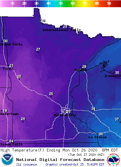
Some spots in the Twin Cities metro area could reach 30 degrees, but that would still be a new record cold high temp for Oct. 26. Our average high temp is 53 degrees in the Twin Cities this time of year!
Low temperatures late Monday night and early Tuesday morning may reach the teens in the metro area, with some single-digit lows possible in parts of Minnesota:
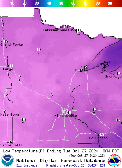
Twin Cities metro area highs are projected to reach the mid 30s on Tuesday, followed by lower 40s Wednesday and Thursday. We could see highs in the upper 40s on Friday. Next Saturday is Halloween, and some forecast models show Twin Cities highs in the lower 50s next weekend.
The new temperature outlook from the NWS Climate Prediction Center is encouraging, showing a tendency toward above-normal temps for the first week in November:
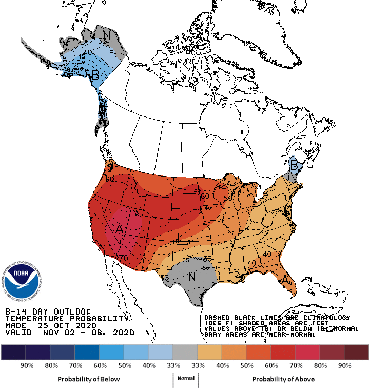
Our current wintry weather may seem like a distant memory by then!
Programming note
You can hear my live weather updates on MPR News at 7:35 a.m., 9:35 a.m. and 4:39 p.m. each Saturday and Sunday.

