
Highs in the 40s and 50s by Halloween
Northern Minnesota gets a wintry mix Wednesday
Go Deeper.
Create an account or log in to save stories.
Like this?
Thanks for liking this story! We have added it to a list of your favorite stories.


Other than a wintry mix of precipitation Wednesday morning, Minnesota stays primarily dry in the week ahead, while temperatures trend mostly warmer.
Wednesday’s forecast
Thanks to light winds out of the south, Wednesday started much milder than Tuesday, with low temperatures in the upper 20s and 30s. Overall, the day will be slightly warmer, with much of the state making it into the 40s.

This is still 5 to 10 degrees below average, but not as cold as our recent trend, where much of Minnesota has been stuck with highs in only the 20s and 30s for over a week.
For example, the last time the Twin Cities saw temperatures above the 30s was way back on Oct. 17, even though the average high for Oct. 28 is 52 degrees.
As of 9 a.m., a cold front moving in along our northern border is bringing a wintry mix of precipitation to northern Minnesota.
Turn Up Your Support
MPR News helps you turn down the noise and build shared understanding. Turn up your support for this public resource and keep trusted journalism accessible to all.
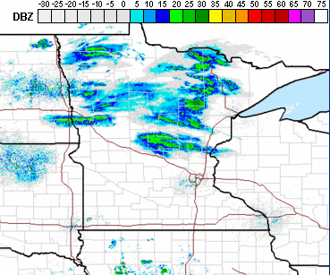
This expected mix of rain, snow and freezing rain will linger across northern Minnesota through the morning, before turning to rain in the afternoon as it exits the Arrowhead.
Although the precipitation stays light, it could cause a few slick spots on the roads, so be careful.
The cold front passes south through Minnesota during the day, but because moisture is so limited, the rest of the state is less likely to see precipitation and should see occasional breaks of sunshine.
Extended forecast
Behind Wednesday’s front, temperatures cool slightly again Thursday, with most of Minnesota back in the 30s for highs.
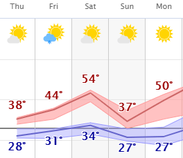
Temperatures then warm again the rest of the week, with more 40s again on Friday and a few 50s by Saturday.
Temperatures dip again Sunday behind another cold front, but they rebound quickly and the rest of next week should see temperatures near and even above average, with highs in the 40s and 50s, with a couple 60s possible.
Here is the Twin Cities forecast through Monday, showing the overall warming trend, with a couple temperature dips behind cold fronts:
Meanwhile, after Wednesday’s wintry mix in northern Minnesota, dry and mostly sunny skies prevail, although a minor disturbance could bring a dusting of snow early Friday.
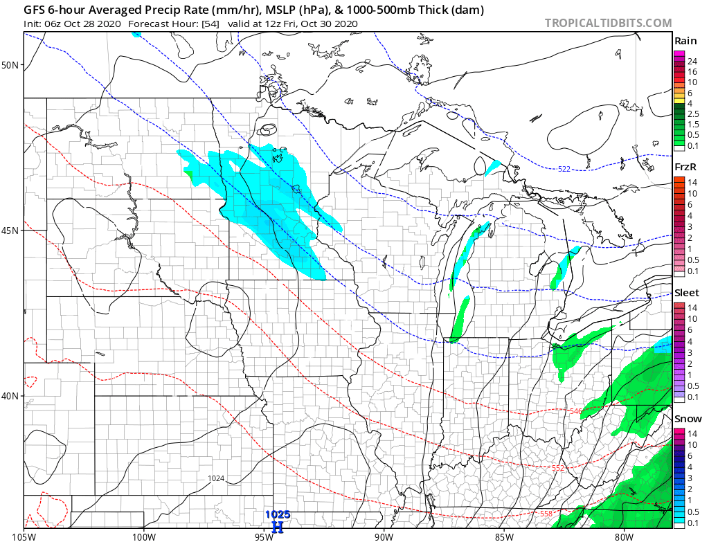
The cold front over the weekend also brings back windy conditions. Next week also looks drier than average in addition to turning warmer.
Programming note
You can hear my live weather updates on Minnesota Public Radio at 7:48 a.m. Monday through Friday morning.

