
A windy Halloween, topped off with a "blue moon"
Colder on Sunday
Go Deeper.
Create an account or log in to save stories.
Like this?
Thanks for liking this story! We have added it to a list of your favorite stories.


Happy Halloween! You’ll be happy to know that there isn’t anything too scary in the forecast.
Windy
A strong low pressure system is moving across south-central Canada today, bringing strong winds to the upper Midwest. A cold front will swing down from that low pressure system later today and tonight. Winds will gust from 25 to 40 mph in many areas today and this evening. Higher gusts, in the 40 to 55 mph range, are possible in northwestern Minnesota and parts of west-central Minnesota, where there’s a wind advisory this afternoon and evening:

________________________________________________________________________________
Turn Up Your Support
MPR News helps you turn down the noise and build shared understanding. Turn up your support for this public resource and keep trusted journalism accessible to all.
Mid-afternoon update
Wind advisories have been expanded to cover much of Minnesota (including the Twin Cities metro area) for the remainder of this Saturday afternoon through Saturday night:

___________________________________________________________________________________________
Gale warnings begin this Saturday evening on Lake Superior:
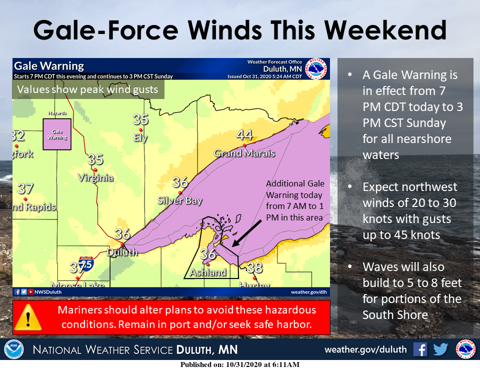
There’s also a small craft advisory Saturday afternoon in the waters closer to shore:
URGENT - MARINE WEATHER MESSAGE National Weather Service Duluth MN 940 AM CDT Sat Oct 31 2020 LSZ142>146-010245- /O.CON.KDLH.SC.Y.0085.000000T0000Z-201101T0000Z/ /O.CON.KDLH.GL.W.0016.201101T0000Z-201101T2100Z/ Taconite Harbor to Silver Bay Harbor MN- Silver Bay Harbor to Two Harbors MN-Two Harbors to Duluth MN- Duluth MN to Port Wing WI-Port Wing to Sand Island WI- 940 AM CDT Sat Oct 31 2020 ...SMALL CRAFT ADVISORY REMAINS IN EFFECT UNTIL 7 PM CDT THIS EVENING... ...GALE WARNING REMAINS IN EFFECT FROM 7 PM CDT THIS EVENING TO 3 PM CST SUNDAY... * WHAT...Today, southwest winds 15 to 25 knots with gusts up to 35 knots and waves 1 to 4 feet. This evening through Sunday afternoon, northwest winds 15 to 25 knots with gales up to 40 knots and waves 3 to 6 feet expected. * WHERE...Port Wing to Sand Island WI, Two Harbors to Duluth MN, Duluth MN to Port Wing WI, Taconite Harbor to Silver Bay Harbor MN and Silver Bay Harbor to Two Harbors MN. * WHEN...For the Small Craft Advisory, until 7 PM CDT this evening. For the Gale Warning, from 7 PM CDT this evening to 3 PM CST Sunday. * IMPACTS...Strong winds will cause hazardous waves which could capsize or damage vessels and reduce visibility. PRECAUTIONARY/PREPAREDNESS ACTIONS... Mariners should alter plans to avoid these hazardous conditions. Remain in port, seek safe harbor, alter course, and/or secure the vessel for severe conditions.
You can hear updated weather information on the MPR network, and you’ll see updated weather info on the MPR News live weather blog.
Mild highs, then temps retreat
Our average Twin Cities high temperature is 51 degrees on Oct. 31. Many spots in the metro area will reach the mid 50s this Saturday afternoon, with falling temps later this afternoon and this evening.
Highs in the 50s are expected across roughly the southern half of Minnesota as well as west-central Wisconsin. Highs in the 40s are forecast for most of northern Minnesota, followed by falling temps. Far northern Minnesota could see temps drop into the 20s this Saturday evening. Twin Cities metro are temps could retreat into the mid 40s by 6 or 7 p.m., then to the upper 30s by 9 or 10 p.m.
Rain or snow chances?
Northern Minnesota will have a chance of scattered rain showers today. The rain showers could mix with a few snowflakes by late afternoon and early evening, followed by some areas of snow showers later this evening and overnight. Central and southern Minnesota, plus western Wisconsin, will have a chance of scattered sprinkles late this afternoon and this evening.
Blue moon

The full moon this evening will be our second full moon this month, so it’s called a “blue moon”. The moon will be a normal color if you do get a glimpse of it through the clouds. The last time that we saw two full moons in one month was in March of 2018.
“Blue moon” can also have another definition, according to earthsky.org:
It can also be the third of four full moons in a single season, with a season being between a solstice and equinox. The next seasonal Blue Moon will be August 22, 2021.
In recent years, people have been using the name Blue Moon for these two different sorts of moons: second of two full moons in a calendar month, or third of four full moons in a single season.
According to earthsky.org, we sometimes do see a bluish moon:
Someday, you might see a true blue-colored moon in the sky. Blue-colored moons are rare – aren’t necessarily full – and happen when Earth’s atmosphere contains dust or smoke particles of a certain size, slightly wider than 900 nanometers. Particles of this size are very efficient at scattering red light. When these particles are present in our air, and the moon shines through them, the moon may appear blue in color.
A chilly Sunday, then back to the 60s
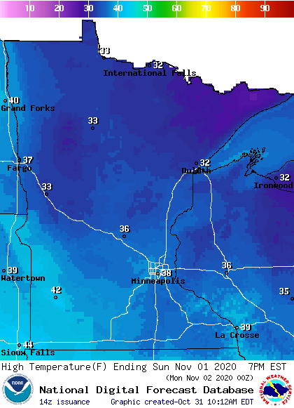
Sunday highs will be mainly in the 30s, with some 40s in southwestern Minnesota:
It’ll still be a bit breezy on Sunday, with gusts of 20-30 mph. Higher gusts are expected near Lake Superior and in parts of western Wisconsin:

Plotted values are in knots, with 21 knots equal to around 24 mph.
Back to temperatures, we’re expecting some warmth next week. Twin Cities metro area highs are projected to reach the lower 50s Monday, followed by highs in the lower 60s Tuesday through Friday. It still looks like a dry week, and I don’t see any weather problems for people who are out voting next Tuesday.
The mild temps may linger through next weekend. The temperature outlook from the NWS Climate Prediction Center shows a tendency toward above-normal temps in Minnesota and Wisconsin from Nov. 5 through Nov. 9:
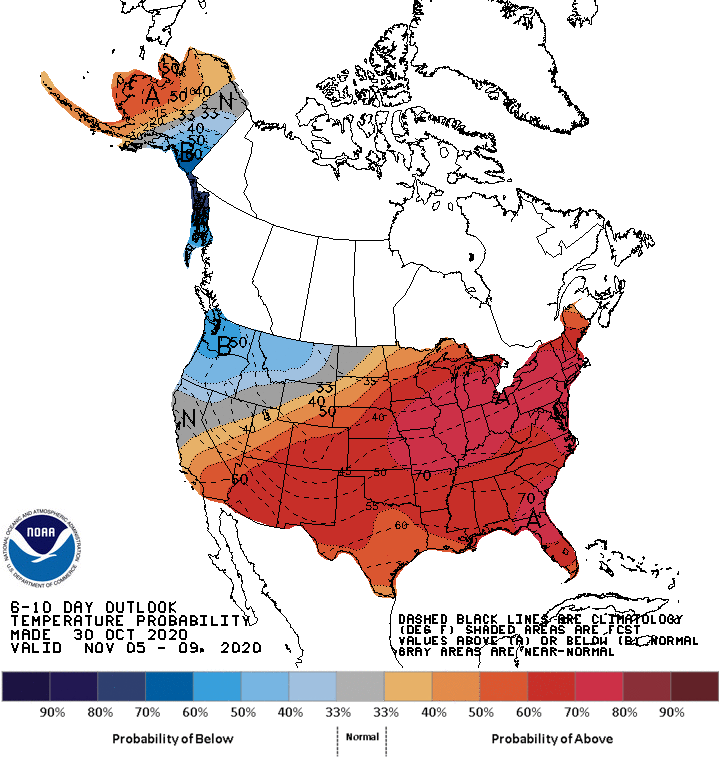
That would be nice!
Programming note
You can hear my live weather updates on MPR News at 7:35 a.m., 9:35 a.m. and 4:39 p.m. each Saturday and Sunday.

