
Warm again on Sunday, but windy
Snow returns on Tuesday
Go Deeper.
Create an account or log in to save stories.
Like this?
Thanks for liking this story! We have added it to a list of your favorite stories.


The Saturday high temperature at Minneapolis-St. Paul International Airport was 74 degrees. That set a new Twin Cities record high for Nov. 7. Our average high is only 46 degrees this time of year.
Our Twin Cities highs of 75 degrees on Tuesday and Friday also set new daily records and our Wednesday high of 74 degrees tied the Nov. 4 record high.
Warm again on Sunday
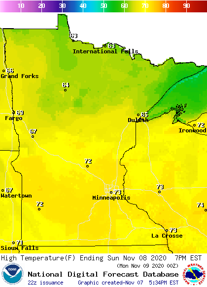
Sunday highs are forecast to reach the 60s in far northern Minnesota, with 70s elsewhere in Minnesota and in western Wisconsin:
Turn Up Your Support
MPR News helps you turn down the noise and build shared understanding. Turn up your support for this public resource and keep trusted journalism accessible to all.
Winds ramp up
A low pressure system over the Dakotas will strengthen on Sunday, bringing strong winds to much of Minnesota and western Wisconsin. Sustained winds of 20-35 mph will be widespread on Sunday, with gusts of close to 50 mph possible. Here are the forecast wind gusts for 3 p.m. Sunday:
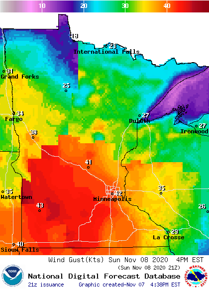
Plotted values are in knots, with 42 knots equal to around 48 mph.
There’s a wind advisory from 10 a.m. to 6 p.m. Sunday for the Twin Cities metro area plus most of central and southern Minnesota and west-central Wisconsin:

The wind advisory begins at 9 p.m. this Saturday and runs until 6 p.m. Sunday in parts of southwestern Minnesota.
Portions of northwestern Minnesota are also in a wind advisory on Sunday:

Here are details on the Sunday wind advisory that includes the Twin Cities:
URGENT - WEATHER MESSAGE National Weather Service Twin Cities/Chanhassen MN 106 PM CST Sat Nov 7 2020 MNZ041>045-047>063-065>070-074>078-082>085-091>093-WIZ014-023-024- 080600- /O.NEW.KMPX.WI.Y.0013.201108T1600Z-201109T0000Z/ Douglas-Todd-Morrison-Mille Lacs-Kanabec-Stevens-Pope-Stearns- Benton-Sherburne-Isanti-Chisago-Lac Qui Parle-Swift-Chippewa- Kandiyohi-Meeker-Wright-Hennepin-Anoka-Ramsey-Washington-Renville- McLeod-Sibley-Carver-Scott-Dakota-Brown-Nicollet-Le Sueur-Rice- Goodhue-Watonwan-Blue Earth-Waseca-Steele-Martin-Faribault- Freeborn-Polk-St. Croix-Pierce- Including the cities of Alexandria, Long Prairie, Little Falls, Princeton, Mora, Morris, Glenwood, St Cloud, Sauk Rapids, Elk River, Cambridge, Center City, Madison, Benson, Montevideo, Willmar, Litchfield, Monticello, Minneapolis, Blaine, St Paul, Stillwater, Olivia, Hutchinson, Gaylord, Chanhassen, Chaska, Victoria, Shakopee, Hastings, New Ulm, St Peter, Le Sueur, Faribault, Red Wing, St James, Mankato, Waseca, Owatonna, Fairmont, Blue Earth, Albert Lea, Osceola, Hudson, and River Falls 106 PM CST Sat Nov 7 2020 ...WIND ADVISORY IN EFFECT FROM 10 AM TO 6 PM CST SUNDAY... * WHAT...South winds 25 to 30 mph with gusts around 50 mph expected. A few gusts may reach 55 mph over western Minnesota. * WHERE...Portions of northwest and west central Wisconsin and central, east central, south central, southeast and west central Minnesota. * WHEN...From 10 AM to 6 PM CST Sunday. * IMPACTS...Gusty winds could blow around unsecured objects. Tree limbs could be blown down and a few power outages may result. PRECAUTIONARY/PREPAREDNESS ACTIONS... Use extra caution when driving, especially if operating a high profile vehicle. Secure outdoor objects.
You can hear updated weather information on the MPR network, and you’ll see updated weather info on the MPR News live weather blog.
Sunday p.m. shower chance west
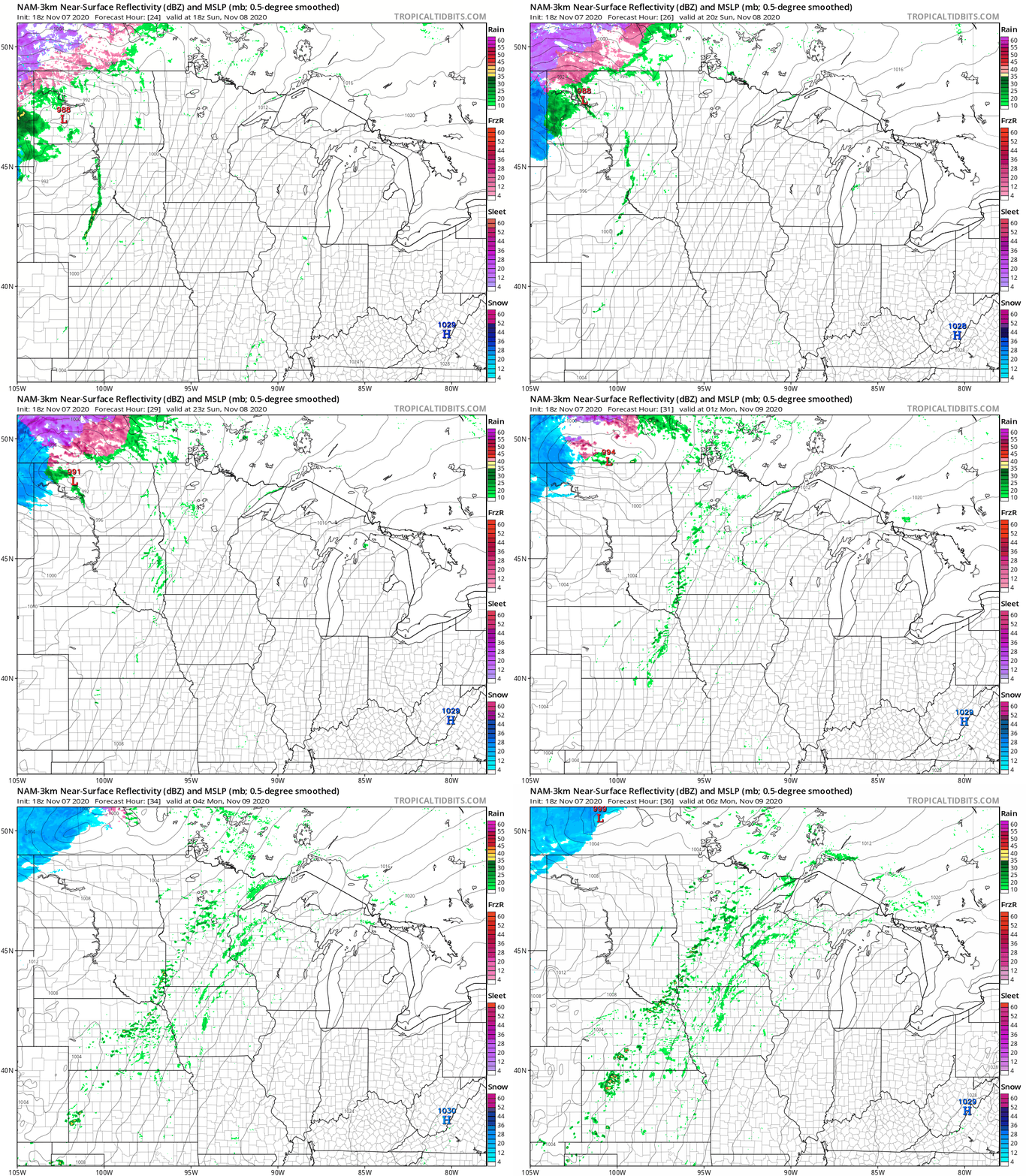
Parts of western Minnesota could see scattered showers Sunday afternoon. That shower chance expands into eastern Minnesota and western Wisconsin Sunday evening.
The National Oceanic and Atmospheric Administration’s North American Mesoscale (NAM) forecast model shows the potential precipitation pattern Sunday afternoon and evening:
Tuesday flakes
On Tuesday, the Twin Cities metro area may see a morning rain/snow mix. That mix is expected to turn to all snow in the afternoon, with snow into Tuesday evening. We’ll have details on possible snow amounts as we get closer to Tuesday, but one forecast model has the metro area near the northern edge of the accumulating snow Tuesday afternoon and Tuesday night, with the highest accumulations from southeastern Minnesota into western Wisconsin.
Temperature trends
Twin Cities metro area highs are projected to reach the lower 60s on Monday. Then it gets a lot cooler, with highs in the upper 30s on Tuesday followed by highs in the upper 30s to around 40 Wednesday through Friday.
Programming note
You can hear my live weather updates on MPR News at 7:35 a.m., 9:35 a.m. and 4:39 p.m. each Saturday and Sunday.

