
A burst of snow Thursday, then weekend rain
Thursday night turns cold, with most of the state dropping into the teens
Go Deeper.
Create an account or log in to save stories.
Like this?
Thanks for liking this story! We have added it to a list of your favorite stories.


Behind a cold front, snow and chillier temperatures spread across Minnesota Thursday. A weekend storm brings rain and snow chances.
Thursday’s forecast
A cold front passed through Minnesota overnight, clearing out through the southeastern corner of the state Thursday morning.
As colder air funnels in behind it, temperatures through the day will rise little from the morning lows in the 20s. In fact, most of the state will stay stuck in the 20s, with only the southeastern corner of the state making it into the 30s.

Breezy winds make it feel even colder, particularly in northern and western Minnesota, where the wind chill stays in the teens.
Turn Up Your Support
MPR News helps you turn down the noise and build shared understanding. Turn up your support for this public resource and keep trusted journalism accessible to all.
The front is also bringing a band of snow behind it, that will keep advancing through southeastern Minnesota through the morning and early afternoon.
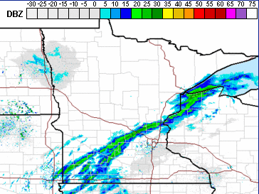
Although the snow line is narrow and does not last long in any location, the rapid burst of snow is enough to reduce visibilities, so be cautious on roadways. Most places are seeing less than an inch, with a few isolated spots up to 2 inches.
There are also a few flurries in northern Minnesota with minimal accumulation expected.

As the snow moves out, skies slowly clear by late Thursday. Between the cold air and no cloud cover for insulation, temperatures drop into the teens overnight, making it the coldest night of the week for most of the state.
Extended forecast
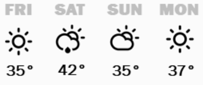
More sunshine returns Friday, but temperatures remain below average, with highs in the 30s.
By Saturday, much of Minnesota could see the lower 40s again, which would be closer to average for mid-November. Another weather system also moves in Saturday, with light rain chances across most of the state, and some snow mixing in, especially in northern Minnesota.
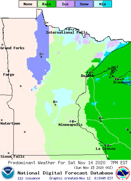
Most of the precipitation clears out by early Sunday, however the northern edge of the state will likely see a little light snow linger into Sunday afternoon. No significant accumulation is currently expected.
That system drops temperatures slightly, so the majority of the state will see highs back in the 30s on Sunday.
Here is that forecast for the Twin Cities:
Next week currently looks less active, with more sunshine and fewer precipitation chances.
Temperatures also warm slightly by the middle of next week, with more 40s returning the state back to average and slightly above average highs for this time of year.
Programming note
You can hear my live weather updates on Minnesota Public Radio at 7:48 a.m. Monday through Friday morning.

